5865 miles from Michigan to California to Montana to Michigan

flinchlock

Senior Member
Joined
Jul 17, 2007
Messages
425
Location
Kalamazoo, MI
(See this thread "Ready to Order Cougar" => http://www.wanderthewest.com/forum/showthread.php?t=655)

Our 101 mile detour south of I-80 in Iowa was very smooth with no delays or heavy traffic.

Trying to sleep in the front seat of the truck turned out to be very difficult. It was very hot both nights and impossible to find any quiet and dark places. I also have a very hard time sleeping sitting up.

Our 2nd night was Salt Lake City were there are about as many mosquitoes as there are salt crystals, but we did get a great picture without too much blood shed.

Salt Lake City, UT
01SaltLakeCity.jpg


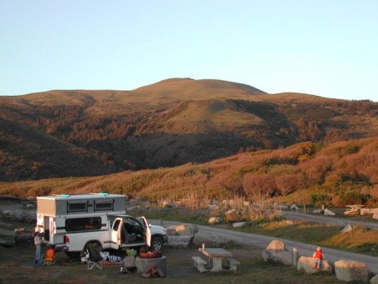
After 2304 miles, we finally got to meet Ben, Marty, Jeff, and Don at ATC. The Cougar camper only lowered the Tundra rear bumper about 2 ¾" and the truck is now about level. After a few hours of me asking a zillion questions, we headed north-west towards the coast.
 
Avenue of the Giants, CA

Trying to find I-5 north with a billion cars/trucks going 100 mph while trying to see behind us turned out to not be as bad as I had feared. Even though the truck and camper both have sliding windows, the camper has the clear door slider and we have a view all the way through the camper to see behind us. We just love the clear door slider!

We took I-5 north about 60 miles to CA-20 to get off the interstate and head towards the coast. Our 1st night in the camper was at the Clearlake, CA, Wal-Mart where we learned to look for a 24-hour Wal-Mart. (wife needs potty 1st thing in the morning, 2nd thing is coffee)

In the morning we decided to take US-101 and avoid Fort Bragg because of fears of lots of traffic. Someplace along US-101 we took "Avenue of the Giants" (a 31-mile section of old US-101) to get a better view of the redwood trees. It was interesting and sad to see the big holes in the big trees.

Chandelier Drive-Thru Tree
02ChandelierDrive-ThruTree.jpg

03ChandelierDrive-ThruTree.jpg


No pictures really show how magnificent and big the trees really are.
03bHumboldtStatePark.jpg

03cHumboldtStatePark.jpg
 
Mattole Road (CA-211)

After about 20 beautiful miles of "Avenue of the Giants", at South Fork, CA, we took Mattole Rd (CA-211) to see how close we could get to the Pacific Ocean. And that turned out to be the most twisted (Not for the car sick) and beautiful side trip we have ever taken!

In Petrolia, we took Lighthouse Road to Windy Point to the King Range National Conservation Area - Mattole Estuary

Our 2nd night in the camper (N40.28987 W124.35581)
04MattoleRecreationSite.jpg

05MattoleRecreationSite.jpg

06MattoleRecreationSite.jpg

07MattoleRecreationSite.jpg
 
Mattole Road (CA-211)

08MattoleRecreationSite.jpg


A beached baby whale. :(
09MattoleRecreationSite.jpg

10MattoleRecreationSite.jpg


That 66 mile trip on Mattole Rd (CA-211, from South Fork to Ferndale) is a trip I will never forget and I would like to backpack that area. I am not 100% sure where California’s Lost Coast starts or ends, but this area is very beautiful!

From The Victorian Village of Ferndale (lots and lots and lots of Victorian homes) we followed US-101 to Crescent City.

Again, no pictures really show how magnificent and big the trees really are.
 
Crater Lake, OR

We next headed to Crater Lake, Oregon.

Generous amounts of winter snow, averaging 533 inches (1,354 cm) per year, supply the lake with water. There are no inlets or outlets to the lake. Crater Lake, at 1,943 feet (592 meters) deep, is the seventh deepest lake in the world and the deepest in the United States. Evaporation and seepage prevent the lake from becoming any deeper.

11CraterLake.jpg

12CraterLake.jpg

13CraterLake.jpg

14CraterLake.jpg
 
The Cove Palisades State Park, OR

Looking for a place to spend the 4th night in the camper, we discovered The Cove Palisades State Park just west of Culver, OR

Geologists believe that 10-12 million years ago, alternating layers of stream sediments, volcanic debris and basaltic lava flows from the Cascade Range were deposited into a huge basin in this area. Named "The Deschutes Formation," these exposed layers of material were capped by lava flows from Cascade volcanoes three million years ago. This cap, known as "The Rimrock Basalt," is easily seen throughout the park high atop the cliffs.

My wife is absolutely crazy about basalt rocks! She wishes she had become a Geologist instead of an Electrical Engineer.

Here are just four of the 26 pictures she took.

15Basalt.jpg

16Basalt.jpg

17Basalt.jpg

18Basalt.jpg
 
John Day Fossil Beds, OR

The next place we spent a lot of time at was John Day Fossil Beds – Clarno Unit

The cliffs of the Palisades are the most prominent landform in the Clarno Unit. The Palisades were formed 44 million years ago by a series of volcanic mudflows called lahars. The Palisades, preserved a great diversity of fossils in an environment very different from that of today.

There are lots of leaf and twig imprints on the rocks.

Notice the two petrified logs?
19FossilBeds.jpg


We also had a great time talking to the Park Ranger stationed here. He said lots of people use their rock hammer right in front of him to get "souvenirs"!
20FossilBeds.jpg
 
Kootenai Falls, MT

Kootenai Falls is one of our favorite to places to visit.

Located on Hwy 2 between Libby, Montana and Troy, Montana, Kootenai Falls is one of the largest free flowing waterfalls in the northwest.

21KootenaiFalls.jpg

22KootenaiFalls.jpg
 
Misc

A picture of us taken out the truck window.
23Shadow.jpg


I just love Montana’s humidity and at least a 40 degree temperature difference between night and day.
FYI: This temp/humidity gauge is an "Acu-Rite Indoor Humidity Monitor 00613" at WalMart for $7.97.
24Humidity.jpg


Our house site looking west.
25House.jpg


We just love our ATC Cougar Camper! :D

Mike & Cheryl
 
Great report and pictures, congrats on the camper, you'll love it more every time you use it. I especially enjoyed the shots of the columnar jointing in the basalt formations, I've got some on file and will post if I can locate them. Thanks for sharing.
 
Did you make it out to Windy Point??
Nope, we really did not explore much other than the beach were we spent the night (N40.28987 W124.35581). We got to the beach late in the afternoon and left early the next morning.

I hope we get back there, but now with the camper there are way too many other places to see!

Mike
 
Mike,

Here are the few columnar jointing shots we have on hand. We found this spot completely by accident while hiking for wild flower pictures a couple of years ago.
 

Attachments

  • HPIM0626 (Medium).jpg
    HPIM0626 (Medium).jpg
    96.7 KB · Views: 245
  • Columns (Medium).jpg
    Columns (Medium).jpg
    92.7 KB · Views: 248
  • IMG_0735 (Medium).jpg
    IMG_0735 (Medium).jpg
    73.4 KB · Views: 239
Here are the few columnar jointing shots we have on hand. We found this spot completely by accident while hiking for wild flower pictures a couple of years ago.
And my wife said...
"Wow", "Beautiful", "Oh my god"
"Beautiful", "Oh my god", "Wow"
"Oh my god", "Wow", "Beautiful"

Mike
 
Those are nice Basalt Rock shots...

Here is a mountian down in Peru with columnar jointing.
 

Attachments

  • Basalt.jpg
    Basalt.jpg
    61.1 KB · Views: 210
the Devils Postpile, near Mammoth Lakes, Ca, is the only thing similar to these photos I have seen..Great stuff! Thanks..

By the way, the whale pictured in this trip report was a full grown sperm whale (male) that had no apparent injuries (apart from his lower jaw missing, researchers took it). He was there in April when I stayed in that exact camp site.
Hard to say how it died, it did have some interesting giant squid scars on it..

pics of Whale and campsite.....Love it there!!!
 

Attachments

  • DSCN2759.jpg
    DSCN2759.jpg
    72.6 KB · Views: 200
  • DSCN2731.jpg
    DSCN2731.jpg
    60.9 KB · Views: 203
Back
Top Bottom