craig333
Riley's Human
Okay, Saturday I decided to go try and finish Pardoe jeep trail. A little background. This is part to the Mormon Emigrant trail that I've done part of before.
Briefly, the Mormon battalion was ready to return to Utah and being shortly after the Donner Party fiasco (plus the 27 water crossings of that route) decided to try the new route that John C. Fremont had scouted to the south. They set off from near Placerville, went through Pollock Pines and followed the ridge (current day mormon emigrant trail road, follows it pretty faithfully till where it joins up with highway 88) up to Iron Mountain. The route follows 88 a couple miles then goes south of Silver Lake for seven miles till it hits a fork in the road. Here you can take the west route to bear river reservoir (in the old days you were probably headed for the stockton gold fields) or east heading towards Kirkwood.
Of course the southern route came a bit later. This T intersection is on an exposed ridge and where I turned around last time due a thunderstorm. Being the high point on a ridge isn't too safe.
Oh yeah, I have no idea why its called Pardoe Jeep trail but that stretch is considered to be from bear river reservoir to the dead end by kirkwood.
Now to the important stuff. I grab my camera dig in my box o'batteries for some fresh lithium batts.
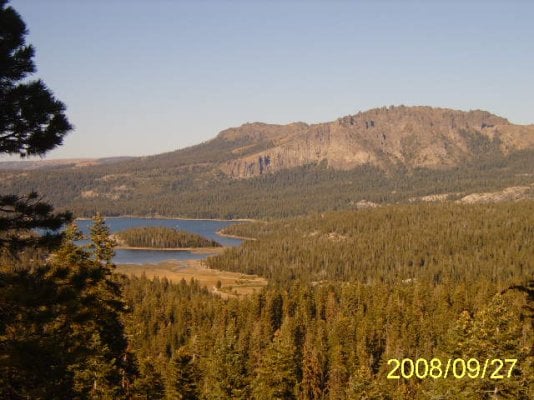
I get a very late start. Its afternoon already when I hit the trail. First stop is a nice view of Silver Lake and the Ridge behind Kirkwood. I snap a pic. It was to be the only pic I got all day. Batteries were dead
Well at the weather is cooperating. No turning back this time (oh yeah, once you reach the T you're on the border of the Mokelumne Wilderness). The trail becomes a real 4wd route about two miles in.
At squaw ridge (well I think the whole thing is squaw ridge but where you find the sign) the view is just spectacular. One of the best views of the Sierra I've seen anywhere. You can see the whole Wilderness area to the south, you can see all the way to the Desolation Wilderness to the north. You can even see all Sacramento Valley to the West. Just an incredible view and I can't take any pictures.
I continue on to the end of trail about another two miles. Here theres a foot/horse trail that goes up the mountain into Kirkwood (West Pass. Then follows Ski lift 4 down the other side). I walked a bit but I'm losing my sun now and I want to get past the rough stuff before its dark.
Theres also a hiking trail that leads in here from highway 88 if you wanted to hike it. One spur leads to a peak overlooking kirkwood/silver lake, another to scout lake and then on into the Wilderness.
I make it through most of the rough stuff before it gets dark. I don't mind wheeling in the dark but solo is a bit risky. Especially when you lose sight of where the road goes. Well I made it back to the easy stuff.
Now I find myself at a spot in the road where I can see the lights from the valley in the distance. Really pretty at night. Then I look up. Whoa. Haven't seen stars like that in a long time. I can't even see the milky way at home, here its so bright and vivid. I just hung out for a while watching the night sky. Rest of the trip was uneventful.
Moral of the story is, bring lots of "fresh" batteries and don't be scared of the dark. I'm so happy I did lose my light on the way. I'd forgotten what I was missing there.
P.S. On the ridge behind kirkwood you can see the ski lift towers if you look real hard.
Briefly, the Mormon battalion was ready to return to Utah and being shortly after the Donner Party fiasco (plus the 27 water crossings of that route) decided to try the new route that John C. Fremont had scouted to the south. They set off from near Placerville, went through Pollock Pines and followed the ridge (current day mormon emigrant trail road, follows it pretty faithfully till where it joins up with highway 88) up to Iron Mountain. The route follows 88 a couple miles then goes south of Silver Lake for seven miles till it hits a fork in the road. Here you can take the west route to bear river reservoir (in the old days you were probably headed for the stockton gold fields) or east heading towards Kirkwood.
Of course the southern route came a bit later. This T intersection is on an exposed ridge and where I turned around last time due a thunderstorm. Being the high point on a ridge isn't too safe.
Oh yeah, I have no idea why its called Pardoe Jeep trail but that stretch is considered to be from bear river reservoir to the dead end by kirkwood.
Now to the important stuff. I grab my camera dig in my box o'batteries for some fresh lithium batts.
I get a very late start. Its afternoon already when I hit the trail. First stop is a nice view of Silver Lake and the Ridge behind Kirkwood. I snap a pic. It was to be the only pic I got all day. Batteries were dead
Well at the weather is cooperating. No turning back this time (oh yeah, once you reach the T you're on the border of the Mokelumne Wilderness). The trail becomes a real 4wd route about two miles in.
At squaw ridge (well I think the whole thing is squaw ridge but where you find the sign) the view is just spectacular. One of the best views of the Sierra I've seen anywhere. You can see the whole Wilderness area to the south, you can see all the way to the Desolation Wilderness to the north. You can even see all Sacramento Valley to the West. Just an incredible view and I can't take any pictures.
I continue on to the end of trail about another two miles. Here theres a foot/horse trail that goes up the mountain into Kirkwood (West Pass. Then follows Ski lift 4 down the other side). I walked a bit but I'm losing my sun now and I want to get past the rough stuff before its dark.
Theres also a hiking trail that leads in here from highway 88 if you wanted to hike it. One spur leads to a peak overlooking kirkwood/silver lake, another to scout lake and then on into the Wilderness.
I make it through most of the rough stuff before it gets dark. I don't mind wheeling in the dark but solo is a bit risky. Especially when you lose sight of where the road goes. Well I made it back to the easy stuff.
Now I find myself at a spot in the road where I can see the lights from the valley in the distance. Really pretty at night. Then I look up. Whoa. Haven't seen stars like that in a long time. I can't even see the milky way at home, here its so bright and vivid. I just hung out for a while watching the night sky. Rest of the trip was uneventful.
Moral of the story is, bring lots of "fresh" batteries and don't be scared of the dark. I'm so happy I did lose my light on the way. I'd forgotten what I was missing there.
P.S. On the ridge behind kirkwood you can see the ski lift towers if you look real hard.