PLSS - public land survey system

HERR42

01110010110101
Joined
Mar 4, 2007
Messages
797
Location
Sacramento, Ca
an article...

http://www.powerset....d+Survey+System

hey DD,

you had access to a GIS guy? maybe he has some BETTER articles on the subject....maybe with decent pics of the locator tags and a professional discussion of the methodology of using the k tags, history, etc.

wouldnt an "industry" guy know some good scoop?

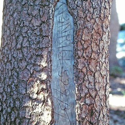
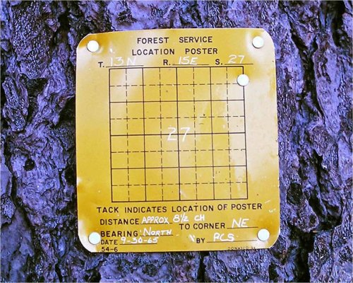
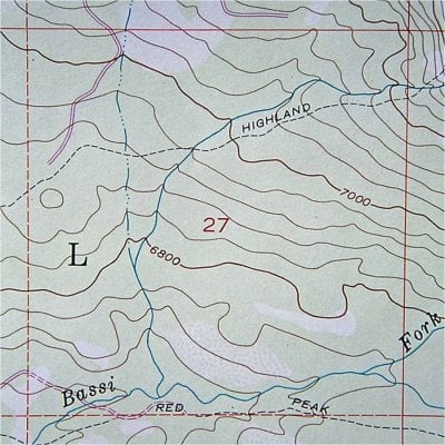
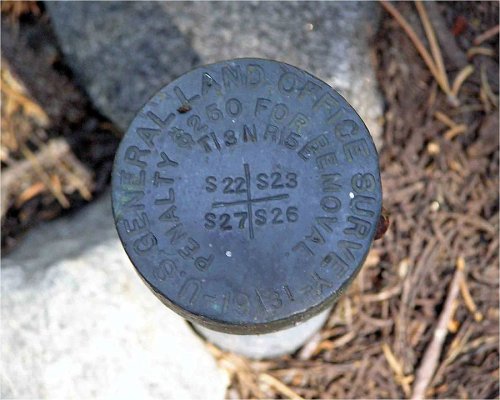
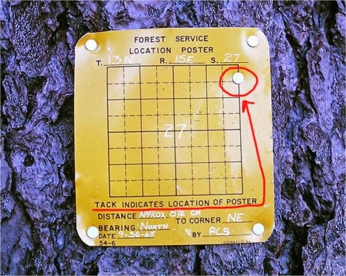
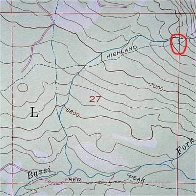
i have used these for years and years and years. i think the population is declining...sometimes it does not look good for k-tags. but then, you spot a brand new one. probably with a bullet hole.

whenever i am in a national forest i am always on the lookout for these tags....just for the fun of it. i have had to use them a number of times. when you need them they sure are handy, and still are a good way to corroborate gps.....a second opinion can help.
 
I'll have to take a look when I get back - in the wilderness!


good place! be on the lookout for those tags!
 
HERR42, thanks much for posting this information. The more folks know about the basics of land navigation and all the various tools available, the safer we'll all be.

We have taught in depth land navigation/map & compass classes for over 16 years through and for state and federal agencies, SAR groups, non-profits, and other organizations. We always include the basics of land survey and the ability to give a quick "legal description" for location.

As an example, grab your Eldorado National Forest map and tell me the name of the lake in the northwest quarter of section 24, township 12 north and range 16 east (NW1/4 Sec 24, T12N R16E). This can be incredibly faster to do in the field than any coordinate system.

All USGS topo maps use 5 primary colors to denote information, black - man made, green - vegetation, blue - water, brown - contour lines, and red - land survey.

And, as you say, finding land survey info or monuments in the woods is fun.

Actually the tag you pictured in your other thread is a bearing tree poster. The "forest location poster" is commonly referred to as the "k tag". In the beginning days of the Forest Service rangers had a list of items they were required to have. It's funny the list was alphabetical and not numerical. At "K" was listed "Forest Location Poster" and "k tag" has stuck ever since.

Lastly, it's called a bearing tree because in the past trees were scribed on four sides of a section corner. If you can understand the information on this tree, know that it is in northern California (Mount Diablo baseline and principal meridian - the starting point), you should be able to find this tree.

Again, thanks for posting this. I love this stuff!
 

Attachments

  • Map & Compass074_edited-1 copy.jpg
    Map & Compass074_edited-1 copy.jpg
    277.5 KB · Views: 187
what a puzzle. i dont want to give it away!
like craig said, you have to unfold the map a ways. using a pdf file is difficult.

i wonder if the k-tags are being maintained at all? sometimes they can be few and far between.
 
HERR42, thanks much for posting this information. The more folks know about the basics of land navigation and all the various tools available, the safer we'll all be.

We have taught in depth land navigation/map & compass classes for over 16 years through and for state and federal agencies, SAR groups, non-profits, and other organizations. We always include the basics of land survey and the ability to give a quick "legal description" for location.

As an example, grab your Eldorado National Forest map and tell me the name of the lake in the northwest quarter of section 24, township 12 north and range 16 east (NW1/4 Sec 24, T12N R16E). This can be incredibly faster to do in the field than any coordinate system.

All USGS topo maps use 5 primary colors to denote information, black - man made, green - vegetation, blue - water, brown - contour lines, and red - land survey.

And, as you say, finding land survey info or monuments in the woods is fun.

Actually the tag you pictured in your other thread is a bearing tree poster. The "forest location poster" is commonly referred to as the "k tag". In the beginning days of the Forest Service rangers had a list of items they were required to have. It's funny the list was alphabetical and not numerical. At "K" was listed "Forest Location Poster" and "k tag" has stuck ever since.

Lastly, it's called a bearing tree because in the past trees were scribed on four sides of a section corner. If you can understand the information on this tree, know that it is in northern California (Mount Diablo baseline and principal meridian - the starting point), you should be able to find this tree.

Again, thanks for posting this. I love this stuff!


I was too lazy to correct him on the bearing tag. Close enough. And for more trivia, you sometimes see them marked as "x number of chains" from somewhere. In the old days that wasn't just a term, they really carried a chain to measure distance.
 
Don't know the answer to that. Problem a victim of budget cuts. Or perhaps they just figure everyone has gps now.
 
In the Forests, survey updates are usually driven by projects. No new projects.......no updates on surveys. It is illegal to mess with survey markers. Yeah, I know, that helps. Craig333 is correct about chains for distance. The bearing tree poster will be inscribed with "bearing" to the section corner (remember surveyors use quadrant compasses and not azimuthal compasses [0 to 360 degrees] that most recreationists use) and "distance" that is many times listed in number of chains and/or links. A "chain" is 66 feet long and has 100 "links".
 
Sounds like I'm already committed to bringing food and beer to the XP Camper gathering, but maybe some of us can bribe Ski and Craig with food and beer to teach a WTW class on this?
 
Let's tie distance measurement together, it helps explain where this all came from and makes it easier to understand and remember. A chain measures 66 feet or 22 yards There are 10 chains in a furlong, and 80 chains in one statute mile. An acre is the area of 10 square chains (that is, an area of one chain by one furlong). A section of land is one square mile (1 mile X 1 mile) A township contains 36 sections and is 6 miles X 6 miles. A section of land contains 640 acres. Didn't you ever wonder where an "acre" came from or why horse races are "furlongs" History!

Ever wonder where the "mile" came from? Hint: Roman soldiers.
 
so i wonder if there were installation guidelines the were applied when the "posters" are installed? i.e. a marker every section? every so many miles? yards? furlongs? along forest service roads?

is there any rhyme or reason as to placement?

it seems happenstance to me....even the markers (set in buried pipe) can be just about anywhere.
 
Land survey markers are in place for starting points for new surveys, if necessary. K-tags are placed as information for aid of locating yourself in relation to these markers. K-tags are meant mostly for surveyors or other project workers.

I captured a few images from one of our instructional powerpoints that may answer some questions and add illustration. The first is a forest location poster. Read the information on it.

The second is a shot of the USGS 7.5 quad for this area centering on section 27. Take the info from the k-tag to the map. You should have a good idea of your location.

Want to find the NE section corner? Walk a bearing of 360 degrees (all bearings are in relation to true north - not magnetic) and walk a distance of 8.5 chains. Here's a photo of the section corner.

The original survey to locate this corner was done in 1931. The next survey was done in 1965 to establish the boundaries of Desolation Wilderness. That's when this k-tag was posted. K-tags are usually posted along travel routes, trails or roads.

As HERR42 and Craig333 have pointed out, if you run across these in your travels, learning to use them can be a real aid in our continual exercise in "staying found".
 

Attachments

  • k-tag-web.jpg
    k-tag-web.jpg
    226.2 KB · Views: 146
  • section-27-web.jpg
    section-27-web.jpg
    220.4 KB · Views: 141
Here's the section corner photo. Also I took the photo of the k-tag 12 years ago. It now, in fact, does have bullet holes in it. Sad. Will it be replaced, probably only if there is new need to locate the section corner because of some new project.
 

Attachments

  • section-corner-web.jpg
    section-corner-web.jpg
    132.9 KB · Views: 125
its solely based on random projects.....wow.

describe the nature of "projects". road surveys every 30 years?

never a "lets go out and add tags as a maintenance project" ?


i am referring only to the k-tag...not the more serious markers and monuments.

its seems that their number is declining as decades go by, at least in my opinion. i havnt seen too many new ones....i.e. dated post 2000

thats a good pic you posted....i scanned through all of my digital stuff and could not find one example!


Thanks for all the neat info. I always enjoy finding these markers as we travel through the land. It's a shame people have to shoot at this type of thing.

Again thanks, Frank
 
...., you should be able to find this tree.


how could i find one tree in a thickly forrested one square mile area?

now if....
....you had a tag, with the location "nail" in place as intended ...and no bullet holes....ok i would agree.

but that tree's marker only indicates a specific section....there is no position info from within the section.
you would have to search a square mile. that could be a tall order.
 
HERR42, sorry about not being clear on the information on the Forest Location Poster and then taking that information to the map. These two photos should help.

Using the info on the map to find the k-tag could go something like this: walk the Highland Trail from west to east, the contour lines indicate a gentle to moderate climb, you can gauge your location as you travel along the trail by paying attention to stream crossings. Notice there are also clues if you have gone too far - you cross the stream again and the terrain steepens. Also remember to pay attention to distance - the k-tag would be about 2/3 of a mile beyond the stream crossing near the center of section 27.
 

Attachments

  • k-tag-circle-web.jpg
    k-tag-circle-web.jpg
    229.5 KB · Views: 126
  • section-27-circle-web.jpg
    section-27-circle-web.jpg
    219.4 KB · Views: 122
that nail provides a lot of info. Ole "PCS" added a lot of help with that tack.

what are the last two characters carved into the tree? is that BT?
 
I have absolutely no idea why people feel the need to shoot things like that. When I target shoot I use paper targets and beer cans. And I make sure its all picked up when I leave. Frustrating when you realize you aren't quite sure where you are only to find a sign all shot up.
 
Back
Top Bottom