Steve Scearce
Contributors
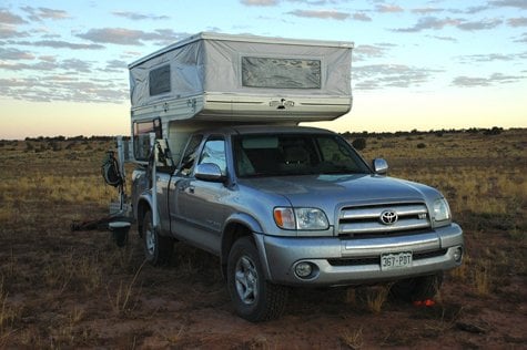
After having our first SE Utah trip in the new/used Phoenix nixed last month by a nasty visit from H1N1, we finally got to take the camper to one of our favorite nearby playgrounds, Cedar Mesa. My wife wanted to hike Slickhorn Canyon access #6, and that sounded good to me, so Friday we bailed on work a little early and headed out. Good stuff. Our "commute" to Cedar Mesa from Durango involves a shortcut from Cortez to Utah through McElmo Canyon, a gorgeous stretch of redrock and autumn cottonwoods. From there we wound through a piece of the Navajo Rez that juts up into SE Utah and made our way into Bluff. Ahh, getting close. Threading the needle through Comb Ridge, we crossed Lime Mesa and skirted Valley of the Gods and began the climb up Moki Dugway in the dark, always fun. At MM 19.1 we cranked a left off the highway the hit the dirt.
The Slickhorn Road is pretty mellow as Cedar Mesa roads go. Mostly sand and clay with the occasional section of exposed slickrock and a few shallow wash crossings. We've traveled this road for years with various vehicles, ranging from a Celica to a Subaru Outback to the Tundra, without a problem... usually pretty fast. I toned it down a bit with the camper on the truck and it went well. I was a little concerned about the hitch rack on the back going thru the washes, but no problems. The headlights lit up a well-worn wooden corral on the right and we turned off on the spur road. It was damned dark and I longed for the 1 gazillion candle power spotlight that was back home on the work bench. We used to take the "Light of God" with us for tent site location and set-up in the dark, but I didn't think about how nice it would be to find a nice, level parking place for the camper. Oops. Next time.
We broke out the new Lynx levelers and did a fairly half-assed job. Didn't bother to crank on the fridge propane, so the lack of level perfection didn't seem like a big deal... until I managed to migrate downhill to occupy a lot of my wife's space in the bed. The next morning she, uh, "encouraged" me to level the sumbitch a little better. I complied.
Sure was nice to fire up the furnace and brew the joe in comfort. Hmm, I could get used to this comfy bed and warmth stuff. The original foam "mattress" and flop-down extension pretty much sucked, so we took our tent camping combo - Thermarest and RidgeRest pads - and stuck 'em under the crappy foam. Ahh, much better! Not quite Serta Perfect Sleeper, but damned civilized.
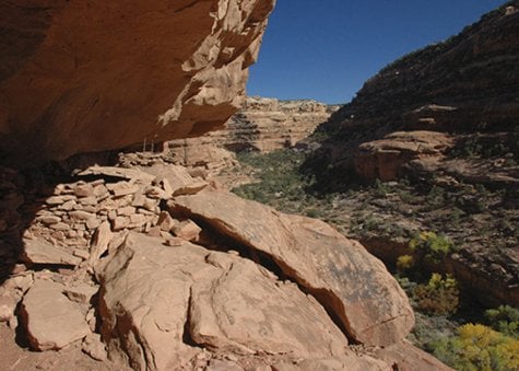
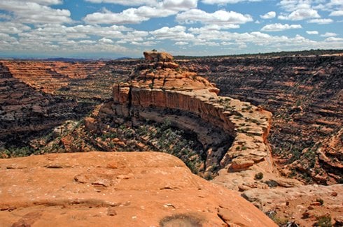
Years ago (I guessed it was mid-'90s) we had hiked down Slickhorn #6 with some pals. We didn't remember any details, so it was fresh and new this time. Guess this is a benefit of aging. There were several pouroffs to bypass and even more boulder-choked sections of canyon to navigate, so no land speed records were set. Eventually we got down to the "Ledge Ruin" that was perched halfway up the north wall of the canyon. We scanned the cliff face for a plausible route up, saw one and started to head that way when my wife spotted another couple up in the ruin. We decided to give them plenty of space and we headed down canyon to the confluence of our fork and the main canyon. The cottonwoods were ablaze with color, and the temps were in the mid-70s. Perfect.
When we returned to the ruin, the other folks were gone and we began the circuitous ascent. The low-angled autumn sun was really cooking us on the climb and when we got to the alcove it was damned hot. The Anasazi knew their passive solar. Guess you pay attention to that stuff when your survival depends on it.
The ruin was interesting on several levels. It was a high and precarious location, so the folks who lived there needed to defend themselves. The structures - granaries, kivas and homes - were spread out along a 100-yard ledge. There was a mix of typical stone and mortar construction, but also several examples of jacal or wattle-and-daub (woven willow and mud) wall construction.
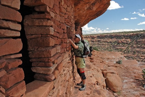
Standing below, we could see a kiva with it's original ladder poking through the roof. This was at the far left end of the ledge, and the traverse to get to that area looked pretty damned hairy from down below. But we know from years of poking around ruins that you can never tell about these things 'til you get up to 'em. Well, the traverse wasn't nearly as hairy as it looked, but it did give us the sphincter pucker. Accessing the traverse ledge meant climbing a pile of three chunks of sandstone leaned against the cliff. They were solid and didn't wobble, which was a good thing. A tumble from there would have resulted in a 400 ft. freefall to the canyon floor. The ledge itself was plenty wide but the drop off was severe. Look straight ahead and ignore that scary stuff in your peripheral vision. Blinders would be useful.
The hike out went a little faster since we had already pieced together routes through to boulder sections and around the pouroffs. Besides, there was the powerful magnet of cold beer drawing us back to the Phoenix. We dined inside and in comfort, not because we needed to, but because we could. Pretty novel stuff for tent campers like us. The three burner cooktop was pretty deluxe, and the sink and running water were mighty nice. The fridge? I've pretty much decided to turn that into the dry storage/pantry. We've got a good cooler or four, and messing with the battery/propane strikes me as a royal pain in the ass.
After a lovely night's sleep, we struck camp (pretty damned fast compared to tent camping!) and drove to the end of the Slickhorn Road to what is called "Slickhorn East Canyon" by some. It's not connected to the main canyon, and ultimately spills into the San Juan River just above Government Rapids, a place we know well. We were there to scout an unknown (to us) canyon for future hikes and a quick blood-warmer hike before heading home. We scrambled down from the canyon rim, passing an interesting water trough that was fed spring water via pipe from above. Weird location for watering stock, we thought. We reached the canyon floor and headed back up the other side to access a granary we had spied from the rim. As we neared the structure, I looked down to see a perfect white quartz bird point! Very, very cool. We admired it and I stuck it under a rock for safekeeping. The granaries were quite intact, despite the poor quality sandstone used in the construction. They were under a significant overhang and were quite protected. A quick scramble to the rim above the structures and we were hiking the mesa top back to the truck. I started seeing a few potsherds - mostly corrugated stuff - and a lot of lithic scatter. We followed these flakes of worked flint uphill trying to find their point of origin. We never did find a structure, but the volume of lithics was really impressive. A lot of tool making had taken place there.
Back to the truck and back to Durango. Good times. After lurking here for a while before joining, I know youse guys like photos, so here are a couple for your viewing pleasure.
The Slickhorn Road is pretty mellow as Cedar Mesa roads go. Mostly sand and clay with the occasional section of exposed slickrock and a few shallow wash crossings. We've traveled this road for years with various vehicles, ranging from a Celica to a Subaru Outback to the Tundra, without a problem... usually pretty fast. I toned it down a bit with the camper on the truck and it went well. I was a little concerned about the hitch rack on the back going thru the washes, but no problems. The headlights lit up a well-worn wooden corral on the right and we turned off on the spur road. It was damned dark and I longed for the 1 gazillion candle power spotlight that was back home on the work bench. We used to take the "Light of God" with us for tent site location and set-up in the dark, but I didn't think about how nice it would be to find a nice, level parking place for the camper. Oops. Next time.
We broke out the new Lynx levelers and did a fairly half-assed job. Didn't bother to crank on the fridge propane, so the lack of level perfection didn't seem like a big deal... until I managed to migrate downhill to occupy a lot of my wife's space in the bed. The next morning she, uh, "encouraged" me to level the sumbitch a little better. I complied.
Sure was nice to fire up the furnace and brew the joe in comfort. Hmm, I could get used to this comfy bed and warmth stuff. The original foam "mattress" and flop-down extension pretty much sucked, so we took our tent camping combo - Thermarest and RidgeRest pads - and stuck 'em under the crappy foam. Ahh, much better! Not quite Serta Perfect Sleeper, but damned civilized.
Years ago (I guessed it was mid-'90s) we had hiked down Slickhorn #6 with some pals. We didn't remember any details, so it was fresh and new this time. Guess this is a benefit of aging. There were several pouroffs to bypass and even more boulder-choked sections of canyon to navigate, so no land speed records were set. Eventually we got down to the "Ledge Ruin" that was perched halfway up the north wall of the canyon. We scanned the cliff face for a plausible route up, saw one and started to head that way when my wife spotted another couple up in the ruin. We decided to give them plenty of space and we headed down canyon to the confluence of our fork and the main canyon. The cottonwoods were ablaze with color, and the temps were in the mid-70s. Perfect.
When we returned to the ruin, the other folks were gone and we began the circuitous ascent. The low-angled autumn sun was really cooking us on the climb and when we got to the alcove it was damned hot. The Anasazi knew their passive solar. Guess you pay attention to that stuff when your survival depends on it.
The ruin was interesting on several levels. It was a high and precarious location, so the folks who lived there needed to defend themselves. The structures - granaries, kivas and homes - were spread out along a 100-yard ledge. There was a mix of typical stone and mortar construction, but also several examples of jacal or wattle-and-daub (woven willow and mud) wall construction.
Standing below, we could see a kiva with it's original ladder poking through the roof. This was at the far left end of the ledge, and the traverse to get to that area looked pretty damned hairy from down below. But we know from years of poking around ruins that you can never tell about these things 'til you get up to 'em. Well, the traverse wasn't nearly as hairy as it looked, but it did give us the sphincter pucker. Accessing the traverse ledge meant climbing a pile of three chunks of sandstone leaned against the cliff. They were solid and didn't wobble, which was a good thing. A tumble from there would have resulted in a 400 ft. freefall to the canyon floor. The ledge itself was plenty wide but the drop off was severe. Look straight ahead and ignore that scary stuff in your peripheral vision. Blinders would be useful.
The hike out went a little faster since we had already pieced together routes through to boulder sections and around the pouroffs. Besides, there was the powerful magnet of cold beer drawing us back to the Phoenix. We dined inside and in comfort, not because we needed to, but because we could. Pretty novel stuff for tent campers like us. The three burner cooktop was pretty deluxe, and the sink and running water were mighty nice. The fridge? I've pretty much decided to turn that into the dry storage/pantry. We've got a good cooler or four, and messing with the battery/propane strikes me as a royal pain in the ass.
After a lovely night's sleep, we struck camp (pretty damned fast compared to tent camping!) and drove to the end of the Slickhorn Road to what is called "Slickhorn East Canyon" by some. It's not connected to the main canyon, and ultimately spills into the San Juan River just above Government Rapids, a place we know well. We were there to scout an unknown (to us) canyon for future hikes and a quick blood-warmer hike before heading home. We scrambled down from the canyon rim, passing an interesting water trough that was fed spring water via pipe from above. Weird location for watering stock, we thought. We reached the canyon floor and headed back up the other side to access a granary we had spied from the rim. As we neared the structure, I looked down to see a perfect white quartz bird point! Very, very cool. We admired it and I stuck it under a rock for safekeeping. The granaries were quite intact, despite the poor quality sandstone used in the construction. They were under a significant overhang and were quite protected. A quick scramble to the rim above the structures and we were hiking the mesa top back to the truck. I started seeing a few potsherds - mostly corrugated stuff - and a lot of lithic scatter. We followed these flakes of worked flint uphill trying to find their point of origin. We never did find a structure, but the volume of lithics was really impressive. A lot of tool making had taken place there.
Back to the truck and back to Durango. Good times. After lurking here for a while before joining, I know youse guys like photos, so here are a couple for your viewing pleasure.