ETAV8R
Senior Member
This is copied from another Expedition Portal where I originally posted it. I didn't take my rig so you won't see a camper. It was quite warm in the truck with a shell on the back.
A friend and I headed out Friday to stay at Panamint Springs Resort and then head into Saline on Saturday. We knew there were storm reports but had no idea what we would discover.
At Mojave the first signs of the storm which began earlier that day started to show.

Heading up the 395 it began to rain and then snow. Just as we turned to our intended goal of checking out some petros at Fossil Falls we came across a bad rollover accident. Further up the road another vehicle, looked like a two-wheel drive suv, was spun out and stuck at the median. Signs about a mile further said chains required. We pushed on to Olancha for fuel and on the way saw a couple truckers putting on chains. Little did anyone know the road would clear in about 2 miles. We stayed in 4HI till we got out of the slush.

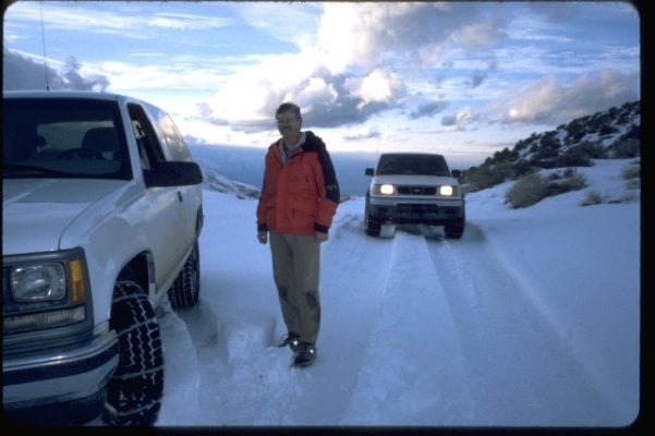
Just a little chilly. We had to fix the sign so all the people going there would know where they were.


The familiar red cinder cone on the east side of 395 just north of Fossil Falls covered in snow.

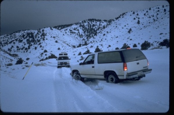
After fueling up in Olancha we headed towards Panamint Springs Resort via 190. There was crazy wind and snow flurries as we climbed up the road to the south. Shortly after the snow on the road began to thicken we saw a plow coming towards us. This was good and bad. Meant the roads had been in a bad condition for a while but good in that they were out there working to keep it clear somewhat. We traveled on in the dark watching the snow hyperspeeding by us. There were a few cars on the road here and there. This was the first trip in a long time where I had opted to not take my own truck. Again this was good so I could check route and weather as we progressed towards the goal of Panamint Springs.
Close to the goal we saw another plow which meant there were at least two in the area working oppposite directions. It would be a long evening for them. We arrived at PSR and paid for the campsite then went to get some tasty chow at their diner. If you haven't had the pleasure of camping at PSR do yourself a favor and get out there. Car/Tent sites are $7.50 and you get access to the showers. It wasn't too busy when we got there. Many open spots. There was a jeep group from Nevada with RV's and their rigs in one section. As we walked up we saw a fullsize Ford with 37's and hardside camper. This would become important for trip planning soon thereafter.
Dinner was great and being a small dining area it is easy to listen to peoples stories of their travels. We sat across from a family of five enjoying pizza. Two guys who were discussing options were also nearby. After dinner we talked with the two guys. They had come across Towne Pass earlier in the day and were stuck in PSR even though they had rooms at the Inn at Furnace Creek. The Inn is not cheap so I can understand their frustration not being able to get across the pass back into Death Valley proper. Chains or 4x4 were required at the pass.
Later on I went to change at the shower area because it was still drizzling outside. I met the husband and son of the family of five. They were in the fullsize Ford mentioned earlier. They were down for the week from Oregon with Saline as their destination. The day before they stayed near Benton Hot Springs where it was already snowing. We arrived about the same time at PSR that evening. Before they got there they had attempted South Pass with no luck. He showed me pictures of the huge truck in the snow up to the top of the tires. He was out in front in drifts between knee/hip height. It was bad out there. Having the family in tow he made the wise decision to come to safe harbor. I told him we would talk more tomorrow.
In the morning at PSR do yourself another favor and get the all you can eat breakfast. It rocks. As our goal of reaching Saline seemed to be further out of reach we leisurely had breakfast and then decided to head up to check out Father Crowley Point. On the way there we passed the road to Darwin Falls and I said I'd never been there. Lets try out the trucks new suspension and tires. We took off on the road to Darwin. This place has some special treasures from goldfish to warped geology.
Cacti at PSR

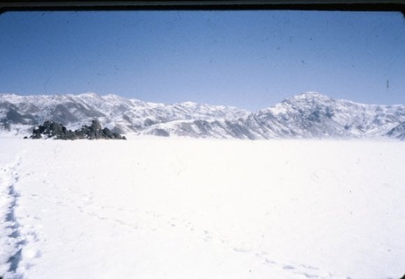
View of Hunter Mountain and the Panamint Dunes

The road to Darwin


Egyptians in DV

Truck for scale. We almost drove right by this twisted mass of rock.

Further down the road we came to a mill and pump station. From acquaintances who live in Darwin/Keeler this pumped water to Darwin in the past. Unfortunately someone was unable to pack out their wine bottle. This is why we can't have nice things.


A friend and I headed out Friday to stay at Panamint Springs Resort and then head into Saline on Saturday. We knew there were storm reports but had no idea what we would discover.
At Mojave the first signs of the storm which began earlier that day started to show.

Heading up the 395 it began to rain and then snow. Just as we turned to our intended goal of checking out some petros at Fossil Falls we came across a bad rollover accident. Further up the road another vehicle, looked like a two-wheel drive suv, was spun out and stuck at the median. Signs about a mile further said chains required. We pushed on to Olancha for fuel and on the way saw a couple truckers putting on chains. Little did anyone know the road would clear in about 2 miles. We stayed in 4HI till we got out of the slush.

Just a little chilly. We had to fix the sign so all the people going there would know where they were.


The familiar red cinder cone on the east side of 395 just north of Fossil Falls covered in snow.

After fueling up in Olancha we headed towards Panamint Springs Resort via 190. There was crazy wind and snow flurries as we climbed up the road to the south. Shortly after the snow on the road began to thicken we saw a plow coming towards us. This was good and bad. Meant the roads had been in a bad condition for a while but good in that they were out there working to keep it clear somewhat. We traveled on in the dark watching the snow hyperspeeding by us. There were a few cars on the road here and there. This was the first trip in a long time where I had opted to not take my own truck. Again this was good so I could check route and weather as we progressed towards the goal of Panamint Springs.
Close to the goal we saw another plow which meant there were at least two in the area working oppposite directions. It would be a long evening for them. We arrived at PSR and paid for the campsite then went to get some tasty chow at their diner. If you haven't had the pleasure of camping at PSR do yourself a favor and get out there. Car/Tent sites are $7.50 and you get access to the showers. It wasn't too busy when we got there. Many open spots. There was a jeep group from Nevada with RV's and their rigs in one section. As we walked up we saw a fullsize Ford with 37's and hardside camper. This would become important for trip planning soon thereafter.
Dinner was great and being a small dining area it is easy to listen to peoples stories of their travels. We sat across from a family of five enjoying pizza. Two guys who were discussing options were also nearby. After dinner we talked with the two guys. They had come across Towne Pass earlier in the day and were stuck in PSR even though they had rooms at the Inn at Furnace Creek. The Inn is not cheap so I can understand their frustration not being able to get across the pass back into Death Valley proper. Chains or 4x4 were required at the pass.
Later on I went to change at the shower area because it was still drizzling outside. I met the husband and son of the family of five. They were in the fullsize Ford mentioned earlier. They were down for the week from Oregon with Saline as their destination. The day before they stayed near Benton Hot Springs where it was already snowing. We arrived about the same time at PSR that evening. Before they got there they had attempted South Pass with no luck. He showed me pictures of the huge truck in the snow up to the top of the tires. He was out in front in drifts between knee/hip height. It was bad out there. Having the family in tow he made the wise decision to come to safe harbor. I told him we would talk more tomorrow.
In the morning at PSR do yourself another favor and get the all you can eat breakfast. It rocks. As our goal of reaching Saline seemed to be further out of reach we leisurely had breakfast and then decided to head up to check out Father Crowley Point. On the way there we passed the road to Darwin Falls and I said I'd never been there. Lets try out the trucks new suspension and tires. We took off on the road to Darwin. This place has some special treasures from goldfish to warped geology.
Cacti at PSR

View of Hunter Mountain and the Panamint Dunes

The road to Darwin


Egyptians in DV

Truck for scale. We almost drove right by this twisted mass of rock.

Further down the road we came to a mill and pump station. From acquaintances who live in Darwin/Keeler this pumped water to Darwin in the past. Unfortunately someone was unable to pack out their wine bottle. This is why we can't have nice things.


") ) to free up a fellow who had been snowed in at South Pass Grapevine for 6 days! The dude that was stuck 6 days had no chains, we brought him some and adapted them to his truck. Plus we worked the path back and forth a bit smoothing down the snow. Considering they had radios and the Park Service would get us out somehow, I was pleased to join in. It takes chains front and rear and you can pretty much go anywhere. I always carry front and rear chains into Saline. We chained the guy up and sent him down to the Springs. Rest of the trip was uneventful, we reached Lee Flat just as darkness set in. Some other time I'll tell you the story of the Chinese tourists we came across that were following GPS and got stranded on Hunter Mountain Road in deep snow. South Pass in snow, if you are prepared and have chains etc. is rather safe. Just be sure to have food and fuel just in case you are stuck a few days.
) to free up a fellow who had been snowed in at South Pass Grapevine for 6 days! The dude that was stuck 6 days had no chains, we brought him some and adapted them to his truck. Plus we worked the path back and forth a bit smoothing down the snow. Considering they had radios and the Park Service would get us out somehow, I was pleased to join in. It takes chains front and rear and you can pretty much go anywhere. I always carry front and rear chains into Saline. We chained the guy up and sent him down to the Springs. Rest of the trip was uneventful, we reached Lee Flat just as darkness set in. Some other time I'll tell you the story of the Chinese tourists we came across that were following GPS and got stranded on Hunter Mountain Road in deep snow. South Pass in snow, if you are prepared and have chains etc. is rather safe. Just be sure to have food and fuel just in case you are stuck a few days.