John Day Fossil Beds National Monument, Oregon
May 12, 2010
A trip! Woohoo! Sometimes Bend feels so remote that you realize how long you can go without leaving the area...
So, my good friends Jesse and Nick, and doggies, Riley and Josie, and I headed out to the Painted Hills and Sheep Rock Units of the John Day Fossil Beds.
PAINTED HILLS UNIT
A few hours in the car, passing several potential return trip milkshake stops in Prineville, through the Ochoco National Forest, and all our PB&J's eaten by 10:30am, we arrived at the Painted Hills. We immediately jumped on the longest hike there: 1.5 miles round trip up Carroll Rim. The view was incredible! The contrasting colors of the various volcanic ash deposits were gorgeous! The weather was perfect- warm sun, cool breeze... The tiny wildflowers were blooming all around...
We then cruised up to the Painted Cove, where we were hoping to let the dogs cool off in the reservoir of water, but when we arrived at the Painted Cove Trail, the road was closed to public use . Poor doggies! So we walked along the Painted Cove Trail (1/4 mile) and it was FABULOUS! The eroding ash displayed a spectrum of colors: purples, reds, tans, pinks... The short little walk was well work the stop!
We looked all over for fossil hunting possibilities between the park boundary and highway, alas, we found none. DirtyDog will have to draw me a map for next time!
MITCHELL
So DirtyDog also prefaced the trip with the town of Mitchell being very interesting... there was a caged black bear in town! Well, we had to stop in town, as it was on our way to the Sheep Rock Unit! We drove into town... wondering if we should ask were the bear was... only to find the town to be about half a block long and as soon as we parked we saw the bear cage.
We walked towards the cage only to hear an older man declare, in an Eeyore-tone,"He ain't here no more." Apparently Henry had to be moved "back to the ranch" due to the inadequate cage and the permits that you needed to have a bear in town... I should have taken a picture of the cage- not looking one bit bearproof... Henry had been taught to play Pattycake and ended up overpowering his Pattycake partner, sending her to the ground... and well, that was the end of Henry in town... I don't know, who is stronger? Human or bear?
SHEEP ROCK UNIT
Thirty-two more miles down the highway and we finally arrive at the Thomas Condon Paleontology Center. Which was AWESOME. An amazing building, constructed in 2003 (Jesse wants me to add in here that the bathrooms were very clean). However, there were no magnets of the park, just in case you happen to have a park magnet collection. Now you know, so you won't be slightly disappointed like myself.
At the Thomas Condon Paleontology Center, you can watch paleontologists extract fossils from the volcanic ash layers that were deposited amongst them. The paleontologist came out to the lobby to tell us all about the 20 million old beaver skull she was working on. She had already put in over 40 hours and you can see the top of the skull and one tooth... she has a ways to go... god speed!
Blue Basin
The Blue Basin is located at the northern part of the Sheep Rock Unit area. NOTE: The bridge across the river to the Blue Basin is being rebuild and we sat for about 15 minutes in the car to get through... Anyway, we hiked the Blue Basin Overlook trail; a three-mile loop. It was a great hike through blue-green colored ash that has great erosive features from weathering. I wouldn't do this hike in the middle of the day in the middle of the summer. It is 100% exposed and it will get very warm as the summer progresses!
The Blue Basin Overlook Trail hooks up with the Island in Time Trail at the end if you hike clockwise. We hike up the Island in Time Trail for a bit, which takes you into the heart of the Blue Basin on a very well maintained trail. We all agreed that the Overlook Trail provided the best views of the basin.
MITCHELL AGAIN
So, the gas light is almost on and we are STARVING after our long day and early consumption of our PB&J's and we return to Mitchell. We ask about gas... the shop in town is probably closed and Dayville (the direction we just drove away from) was 30 miles away and Prineville is about 80 miles away, but it's all downhill, we're told... We decide to test the tank and head to Prineville.
The best thing we discovered in Mitchell: Maple Bars!! A rectangular donut... that we swear the lady made from scratch and she swore the maple frosting was her mother's recipe... Ravenous folks have never had such an amazing maple bar... You must stop at the little espresso hut on the main highway in Mitchell to taste these! And you should be very hungry to ensure full satisfaction.
The end... Wait, no, we rolled into Prineville on fumes! That was good, otherwise we might still be walking...
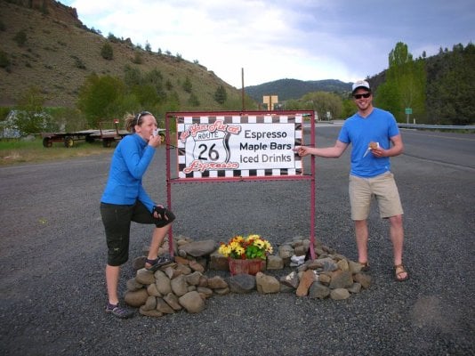
Photo Caption 1: Jesse and Nick devouring their maple bars in Mitchell!
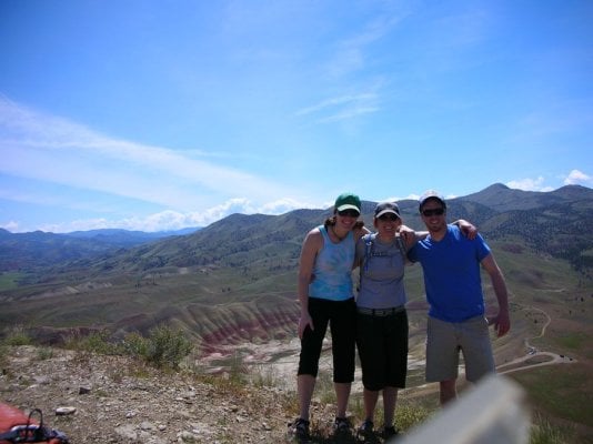
Photo Caption 2: TDawg, Jesse, and Nick on top of the Carroll Rim Trail in Painted Hills.
May 12, 2010
A trip! Woohoo! Sometimes Bend feels so remote that you realize how long you can go without leaving the area...
So, my good friends Jesse and Nick, and doggies, Riley and Josie, and I headed out to the Painted Hills and Sheep Rock Units of the John Day Fossil Beds.
PAINTED HILLS UNIT
A few hours in the car, passing several potential return trip milkshake stops in Prineville, through the Ochoco National Forest, and all our PB&J's eaten by 10:30am, we arrived at the Painted Hills. We immediately jumped on the longest hike there: 1.5 miles round trip up Carroll Rim. The view was incredible! The contrasting colors of the various volcanic ash deposits were gorgeous! The weather was perfect- warm sun, cool breeze... The tiny wildflowers were blooming all around...
We then cruised up to the Painted Cove, where we were hoping to let the dogs cool off in the reservoir of water, but when we arrived at the Painted Cove Trail, the road was closed to public use
. Poor doggies! So we walked along the Painted Cove Trail (1/4 mile) and it was FABULOUS! The eroding ash displayed a spectrum of colors: purples, reds, tans, pinks... The short little walk was well work the stop!We looked all over for fossil hunting possibilities between the park boundary and highway, alas, we found none
. DirtyDog will have to draw me a map for next time!MITCHELL
So DirtyDog also prefaced the trip with the town of Mitchell being very interesting... there was a caged black bear in town! Well, we had to stop in town, as it was on our way to the Sheep Rock Unit! We drove into town... wondering if we should ask were the bear was... only to find the town to be about half a block long and as soon as we parked we saw the bear cage.
We walked towards the cage only to hear an older man declare, in an Eeyore-tone,"He ain't here no more." Apparently Henry had to be moved "back to the ranch" due to the inadequate cage and the permits that you needed to have a bear in town... I should have taken a picture of the cage- not looking one bit bearproof... Henry had been taught to play Pattycake and ended up overpowering his Pattycake partner, sending her to the ground... and well, that was the end of Henry in town... I don't know, who is stronger? Human or bear?
SHEEP ROCK UNIT
Thirty-two more miles down the highway and we finally arrive at the Thomas Condon Paleontology Center. Which was AWESOME. An amazing building, constructed in 2003 (Jesse wants me to add in here that the bathrooms were very clean). However, there were no magnets of the park, just in case you happen to have a park magnet collection. Now you know, so you won't be slightly disappointed like myself.
At the Thomas Condon Paleontology Center, you can watch paleontologists extract fossils from the volcanic ash layers that were deposited amongst them. The paleontologist came out to the lobby to tell us all about the 20 million old beaver skull she was working on. She had already put in over 40 hours and you can see the top of the skull and one tooth... she has a ways to go... god speed!
Blue Basin
The Blue Basin is located at the northern part of the Sheep Rock Unit area. NOTE: The bridge across the river to the Blue Basin is being rebuild and we sat for about 15 minutes in the car to get through... Anyway, we hiked the Blue Basin Overlook trail; a three-mile loop. It was a great hike through blue-green colored ash that has great erosive features from weathering. I wouldn't do this hike in the middle of the day in the middle of the summer. It is 100% exposed and it will get very warm as the summer progresses!
The Blue Basin Overlook Trail hooks up with the Island in Time Trail at the end if you hike clockwise. We hike up the Island in Time Trail for a bit, which takes you into the heart of the Blue Basin on a very well maintained trail. We all agreed that the Overlook Trail provided the best views of the basin.
MITCHELL AGAIN
So, the gas light is almost on and we are STARVING after our long day and early consumption of our PB&J's and we return to Mitchell. We ask about gas... the shop in town is probably closed and Dayville (the direction we just drove away from) was 30 miles away and Prineville is about 80 miles away, but it's all downhill, we're told... We decide to test the tank and head to Prineville.
The best thing we discovered in Mitchell: Maple Bars!! A rectangular donut... that we swear the lady made from scratch and she swore the maple frosting was her mother's recipe... Ravenous folks have never had such an amazing maple bar... You must stop at the little espresso hut on the main highway in Mitchell to taste these! And you should be very hungry to ensure full satisfaction.
The end... Wait, no, we rolled into Prineville on fumes! That was good, otherwise we might still be walking...
Photo Caption 1: Jesse and Nick devouring their maple bars in Mitchell!
Photo Caption 2: TDawg, Jesse, and Nick on top of the Carroll Rim Trail in Painted Hills.