Klamath-Sheldon-Black Rock in Feb?

natjwest

Contributors
Joined
Aug 18, 2010
Messages
312
Location
Portland Orygun
I'm heading down to Bishop again this winter with hardened road warrior daughter and thinking about going via Black Rock. Will the overland "roads" that WtWers take to get there from Oregon be open at that time of year?
 
Since nobody else has responded yet...even though I can't give you a definitive answer, I'll offer my guesses...and this handy (I hope) map -- handy for referring to possible routes, if nothing else:

140-Gerlach.jpg

The routes in red on my map are paved, blue is unpaved, yellow is unpaved and (generally) less-traveled/more-primitive.

By "overland" I assume you mean unpaved roads?

Referring to map alternatives A, B, and C, with subroutes A1 and A2 and connectors X, Y, and Z:
  • I've never driven any of these in mid-winter, though I've driven them all in summer/fall (B just this past October on the way to the Rally, and A2 just last week after T-day).
  • We know that the Stolpas got stuck in snow somewhere along -- or just off -- A2, and lost part of their feet to frostbite...so that's one data point to consider.
  • Routes A (with either northern sub-route) and B both include stretches over 6000 feet. Route C is not much over 4000 feet at any point. Not only is it the lowest-elevation, it is also the eastern-most and so the most rain-shadowed (driest) of the 3 major alternatives.
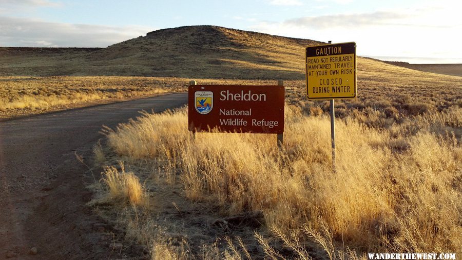
  • I've been down C (which takes off from 140 at Leonard Creek Rd) as far as King Lear Pk many times -- grilled a whole turkey on T-Day at the mouth of McGill Cyn (below King Lear Pk) twice. I've continued on down to Sulfur and over to Gerlach at least 3 times. That east arm of the Black Rock is the least-visited part of that desert -- I love it! I would be willing to bet that it would be passable at any time in the winter, barring a major blizzard. It probably becomes less passable in spring as run-off crosses the road -- mainly near Jackson Creek -- and makes it muddy.
  • C, however, doesn't go through any of the Sheldon Refuge, and it has the most pavement...but that pavement -- 140 -- is a pretty lonely road, it feels pretty wild and it passes over some of the highest high-desert you can drive on a paved road -- over 6000 feet. It's a highway where you could urinate in the middle of the road in the middle of the day and probably not violate anyone's sensibilities. ;) ...except for the feral donkeys who might be watching.
  • If winter snows (or spring mud) weren't a factor...then it seems like a cool wander that includes much of Sheldon Wildlife Refuge would be to take off 140 at A1, then take X over to A2, then Y over to B, then Z over to C, then follow that down to Gerlach. Of course, there are more-primitive roads/tracks all through there.
Overall, whether or not A or B -- and/or X, Y, Z -- are passable in winter depends somewhat on the winter (i.e., wet or dry). Because it's high desert, it's not an area that gets really deep snow -- not like similar elevations in the Cascades anyway, but because there are winds there can be deep drifts, drifts too deep to pass. And these routes are all marked "not maintained in winter" or even "closed"

An all-paved (almost-all-weather) fall-back option (not drawn on the map, but the roads are shown) is taking US 395 from Lakeview to just north of Alturas, then 299 to Cedarville , then south to Gerlach on 447. It is all pavement, but once you get to the south end of the Surprise Valley it's a very remote/wild high-desert drive (other than during the Burning Man season, when it becomes the primary route to that fest from the Northwest).

I bet that your best WTW source of first-hand experience with these roads is Mr. Smokecreek1. His profile says he worked and played all through this area. His profile shows that he hasn't been on WTW since you posted this. Maybe send him a PM and/or email?

Happy (and safe) trails!
- Mark
 
Thanks so much for doing my homework for me Mark. I won't be leaving for a couple months, but it's the next trip on the schedule so I'm planning now.

I have the Benchmark atlas for Oregon. Is there a similar "best" atlas/map for Nevada or just the Delorme Gazeteer?

Am I right that the "playa" is just SE of that straight-ish section at the south end of B?
 
Thanks so much for doing my homework for me Mark. I won't be leaving for a couple months, but it's the next trip on the schedule so I'm planning now.
I have the Benchmark atlas for Oregon. Is there a similar "best" atlas/map for Nevada or just the Delorme Gazeteer?
Am I right that the "playa" is just SE of that straight-ish section at the south end of B?

You're welcome! :) I like doing stuff like this...and as a retired guy I have the time.

Benchmark is available for Nevada (and CA, UT, etc.) and Benchmark >> DeLorme! Fewer misleading road-quality designations. (some friends of mine ended up riding 15 horrible miles on a gravel road on their skinny-tired road bicycles after the Gazeteer showed it as paved...why they didn't stop and turn back is another question...
blink.gif
)
Get Benchmark for all your state-atlas needs! (and get the Michelin for your national road-atlas needs ;))

Yes, route B runs along the west side of the playa. Actually, you can drive the southern-most 30 miles of B on the playa, if it's not wet. It's smoother than the washboardy "shore" road.

BTW: Even though I was singing the praises of route "C", you should know that the part of the desert that C is next to is not hard, drivable playa -- it has a little vegetation and soft spots -- except near it's southern end. I still think it's very cool for hiking-exploring...just not for driving on (mostly).

I'd still recommend getting an opinion from Smokecreek, if you can.
 
I just want to add a bit to what Mark has said so well above. 140, although paved, is indeed a very lonely road and plowing in winter might be less often than we would like. Even on a clear day, large drifts can form across the road quickly in that high, windy desert.

Also, I was once on B just above Gerlach driving south on a snowy day with an inch or two of dry snow on the playa. With no visible landmarks and white in all directions, it was very disorienting. A lot like skiing in a white out. After driving in the center of the playa for a while, we drifted west until we could see the sagebrush along the shore. Then it was no problem navigating the rest of the way to pavement.
 
Thanks for that Stew. I believe I am going to figure out the exact route just before we leave via a phone call to the BLM for current conditions.
 
I believe I am going to figure out the exact route just before we leave via a phone call to the BLM for current conditions.

An excellent idea!
 
Thanks for that Stew. I believe I am going to figure out the exact route just before we leave via a phone call to the BLM for current conditions.


That's right, make sure you call BLM/USFS/USFWS before you anywhere in that NE Calif/NW Nevada/ Central Oregon area anytime between late September and late April. I don't know how many people we have pulled out or have got stuck and stranded out there from late Fall to mid Spring and have had a long walk (Me included-even slept under a sage brush one time after i got stuck and tried to walk out-yep-my buddy was just over the hill in his truck, but the radio went out on me and i spent the night out there-you learn or don't make it), the mud was so thick and deep and a real feature you have to deal with-snow is one thing, mud is a real bad other). First things first, winging it is fine during the summer, but not a good idea during that time of the year and Feburary is a real scary part of the year out there even on the few paved/gravel roads because a nice cold clear day can turn bad real fast when it warms up or a unplanned storm front moves in and dumps 5 feet of snow! Okay, 396 north is the best way to go, but can ice up with black ice on the passes-Reno to Janesville can be a real bitch and dangerous-a 1 1/2 hour drive can take allot longer-real lot, the Black Ice is real bad on Sage Hen Summit north of Likely and the flats between Ravendale and Likely. Never liked the down hill south of Lakeview either, If you feel like being adventurous try going from Nixion, Cederville or Susanville to Gerlach or visa-versa,via the Smoke Creek Desert-Gerlach road-it's gravel and usually passable (seen the usps on the road many times, heading north) with some mud. Smoke Creek Ranch Road (ca side real bad/nev-gravel and not so bad) and the Ravendale to Duck Flat back country By-way off of 395n, can be an adventure, especially around the Willow Springs/creek area on SCR road-we used to take two trucks anytime we had to drive through that area-real bad! My major problem of driving in this country off of the main roads during this time is the tire tracks/ruts you leave behind if you make it through or not , it really messes up the road for the rest of the year! Something to check when you get near Reno is the CBS local weather on TV channel (KTVN), it has a nice maps on its site of all nevada and adj. ca roads and its up to date with current conditions. We have been in a long drought up here and we have not real got a good snowy winter for a while, no snow on the ground here in Suzieville, just on the mountain tops-`but things can change hopefully. Again any of the roads can be open or closed, just call BLM, etc and ask them what its like out there when you get close-we used to like to try to impress people who called us about how much we knew about the country-no really give them a call-its part of their job and its your tax money, maybe write down their Phone # before you leave-and call before you get in the dead cell phone zone up there. People like to drive high rock canyon in the winter and stay in the line camps in the canyondon't know if they are still open to the public, its worth a call to the Cederville BLM to find out. Anyway hope this helps have any specific questions about specific area ask! Have a good run and take care and good luck!
 
Back
Top Bottom