Jack
Senior Member
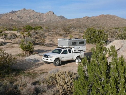
Took this picture about 5min ago in the Mojave Preserve, about 10min south of Kelso, CA.
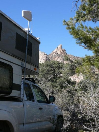
We got a Verizon air card a few months ago, after being inspired by Buzzman, who used one during his recent westward wandering. I like the idea of posting a trip in real time. I'll very soon see how real this can be as we travel the preserve.
The air card has worked out quite well, actually. In addition to allowing us to check email and do some work related research on the (dirt) road. We have also found it extremely useful for weather reports and when driving through large cities en route to said dirt roads. Going up the coast to Oregon from LA through San Francisco, the passenger has the laptop on lap and sigalert.com on the screen. It let us pick the optimal freeway route through the bay area. And in wintertime, weather reports are particularly helpful.
We did a good bit of research on coverage and concluded that Verizon and ATT have the best overall coverage. However, ATT is only worth considering for data service if you already have ATT cell service. We have T-Mobile for cell service and have used ATT pay-as-you go for coverage (which is how they do data service if you don't have cell service) in non T-Mobile areas and it is an extreme PitA. Verizon, on the other hand, is quite happy to set up a data only account. Sprint/Nextel seems to have the best data service but not nearly as good coverage.
Verizon data costs about $60/month (ATT is similar) for 5gb. I have yet to use more than 400mB. Beware, however, that it's $0.25/mB ($250g above the limit. A side note on Verizon: don't trust their usage summary, but check the usage log and tally the totals yourself. The log is accurate, the summary can be weeks behind. We purchased the air card online for about $125, so we were able to sign up with Verizon on a month to month basis (instead of a 2 year contract). Verizon also allows us to suspend the air card for up to 3 months without having to pay a startup fee.
So what has been the experience of other WtWers with internet access, (or, Buzzman, what's new)?
We got a Verizon air card a few months ago, after being inspired by Buzzman, who used one during his recent westward wandering. I like the idea of posting a trip in real time. I'll very soon see how real this can be as we travel the preserve.
The air card has worked out quite well, actually. In addition to allowing us to check email and do some work related research on the (dirt) road. We have also found it extremely useful for weather reports and when driving through large cities en route to said dirt roads. Going up the coast to Oregon from LA through San Francisco, the passenger has the laptop on lap and sigalert.com on the screen. It let us pick the optimal freeway route through the bay area. And in wintertime, weather reports are particularly helpful.
We did a good bit of research on coverage and concluded that Verizon and ATT have the best overall coverage. However, ATT is only worth considering for data service if you already have ATT cell service. We have T-Mobile for cell service and have used ATT pay-as-you go for coverage (which is how they do data service if you don't have cell service) in non T-Mobile areas and it is an extreme PitA. Verizon, on the other hand, is quite happy to set up a data only account. Sprint/Nextel seems to have the best data service but not nearly as good coverage.
Verizon data costs about $60/month (ATT is similar) for 5gb. I have yet to use more than 400mB. Beware, however, that it's $0.25/mB ($250g
above the limit. A side note on Verizon: don't trust their usage summary, but check the usage log and tally the totals yourself. The log is accurate, the summary can be weeks behind. We purchased the air card online for about $125, so we were able to sign up with Verizon on a month to month basis (instead of a 2 year contract). Verizon also allows us to suspend the air card for up to 3 months without having to pay a startup fee.So what has been the experience of other WtWers with internet access, (or, Buzzman, what's new)?