I'm with Monte. Heck, even a KOA campground for "luxury" accommodations is OK for a night or two. Regroup as needed and then head out for a week or more before hitting a KOA or motel.
You are using an out of date browser. It may not display this or other websites correctly.
You should upgrade or use an alternative browser.
You should upgrade or use an alternative browser.
Three Month Home Base in Southwest
- Thread starter buckland
- Start date
I have not been able to talk my lovely wife into a motel night since we got the camper. Romantic dinner? What could be more romantic than watching the stars after enjoying a 'loaded' wedge salad and some chocolate then daring the desert cold to get us while under our Pendleton wool blankets? The stars, yes the stars. Then getting whupped at scrabble (she is also a retired k-8 teacher, which gives her an unfair advantage!)ski3pin said:If I was planning a trip as you describe, I'd drop the idea of renting a house. For a "rest" from the road, I would get a nice motel room for a night or two. We'd resupply with groceries, do laundry, a long shower, and go out for a romantic special dinner. For us, that would be our only touch of civilization.
Now, to be honest, I've never been able to talk Julie into this. She prefers the camper always.
Back to Rob's plan. An important consideration, kind of inescapable, is the great stretches of empty between places. For example, we have gone into Pahrump for groceries, laundry and gas, but don't want to stay there overnight -- so we drive another hour or so to soak in the hot springs at Tecopa (developed, but not fancy) and then jet into Death Valley, get at least a mile off pavement, in a place like Greenwater Valley (not green, no water) then pull over and make dinner, spend the night, get up and make coffee, eat a cup of museli, before going someplace more interesting.
In general, most places you can stock up on water, food, gas and do laundry are not wonderful places to overnight.
OP
OP
buckland
Senior Member
Seems like I will have to wrap my head around the idea that it is possible to find a remote spot and camp... A concept hard to grasp in these NE parts. I better book up on quality topo maps both iPad off line (I have my own GPS unit to link to) and paper. Like tools, never pass up an opportunity/excuse to get more! I know traveling with a dog can crimp some plans and complicate some places to visit but I am a dog nut and can't imagine her not with us. Appreciate everyones opinion. Not booking a place as a base would sure save a lot of money as well... so we can splurge on food more!
OP
OP
buckland
Senior Member
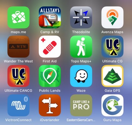
I bought the years Gaia Premium having used the basic. A screenshot below are my traveling iPad apps. I am currently looking for a good tutorial for the Gaia and will try to learn up now. As far as all those beautiful roads I have seen photos on WTW for the last 11 years.... where folks roam into NP, BLM, Monuments, etc. which would be the best to use to determine which dirt roads are open to travel on?
Attachments
For us Benchmark Road & Recreation Atlases for each state. Both paper and digital are very good, though not perfect. Also, where coverage is available, National Geographic Trails Illustrated topographic maps, paper and digital, are even better, but coverage is limited. Google maps and our Garmin Drive Smart 65 are fine for highways, towns, cities and developed areas, but often badly misleading in the backcountry.
The USFS puts out some Motor Vehicle Use Maps in paper and sometimes in digital/GPS navigable form.
Bureau of Land Management has Georeferenced PDF maps for several areas: https://www.blm.gov/maps/georeferenced-PDFs
A weather band radio is handy since some roads become impassable when wet.
The USFS puts out some Motor Vehicle Use Maps in paper and sometimes in digital/GPS navigable form.
Bureau of Land Management has Georeferenced PDF maps for several areas: https://www.blm.gov/maps/georeferenced-PDFs
A weather band radio is handy since some roads become impassable when wet.
OP
OP
buckland
Senior Member
Thanks for the leads. Impressed with the Nat Geo maps with Gaia. We have Midland walkie talkie GMRS radios (2 hand held and a cab radio) It has weather band as well. I have been going to BLM map sites and their interface is very .... well.... designed by an engineer... as opposed to an artist. Old PC user klutzy. No doubt has incredible amount of detail info but hard to navigate.
I will go to MVUS maps soon. Appreciate the steer.
Rob
I will go to MVUS maps soon. Appreciate the steer.
Rob
daverave
Senior Member
We have a Garmin inReach emergency beacon (which I consider essential if you are getting seriously off-pavement in the desert) which came with an app called Earthmate. It is my go-to app for figuring out where to go on the fly particularly as it does a great job of delineating what kind of land (USFS, BLM, NPS, tribal, etc.) you are driving through when looking for places to camp. I also like Avenza maps if I've downloaded them before leaving home. There are a lot of free MVUMs for FS land available there to download. Second the need to plan in advance on Google Earth to see what you may be getting into roadwise... although I've been fooled a time or two or three because it's a 2D look at the planet and elevation changes can be overlooked.
I third the suggestion to look into Borrego Springs. We'll be in that area in January, mostly boondocking in the state park but also a couple of nights at a motel. It has a clothing-optional pool! ;-) Tecopa has never struck me as a place we'd care to hang out, it feels a bit rough around the edges.
I third the suggestion to look into Borrego Springs. We'll be in that area in January, mostly boondocking in the state park but also a couple of nights at a motel. It has a clothing-optional pool! ;-) Tecopa has never struck me as a place we'd care to hang out, it feels a bit rough around the edges.
OP
OP
buckland
Senior Member
It seems to be a popular place! We have had 5 recommendations for Borrego Springs already. We would be also boon docking except for a night stay at a motel. We hadn't thought of going that far west but we have around 13 weeks so why not I guess? Just want to be able to stop and smell the roses (or in this case cacti). Don't want to be a driving fool. I actually love driving places but also want to sit in my chair or go for a hike with my dog (and wife!!!). R-E-L-A-X.
Is the State park boondocks camping just that? Or must one register? Is its a competitive thing that time of year for a spot away from others? I crave those camp sites I have seen photos of here on WTW for the last 11 years. Seems almost impossible for me to think that actually getting away to those spots is not an extreme sport. For us in the east ... when we seek those spots one has to go into to some remote hard to get to areas, real hard to get to.... like Labrador.
I am hopeful and I do love the planning but much will have to be left to on the fly. I am getting into the Gaia maps. they have a new one called Gaia Overland which combines topo, USFS, public, MVUM, BLM into one map. So far pretty nice ...learning the ropes. I will down load all western map areas before departure as well I have my own GPS unit in the truck that the iPad connects to so all maps will be accessible. We live in an area without hardly any cell so we have learned to be self sufficient map-wise.
Thanks again for your input.
daverave
Senior Member
I could see how Borrego much less most of California would be out of the way on your trip. We've only been there maybe three times pre-pandemic so I can't answer to how competitive the boondocking has become but I would assume that it is an order of magnitude worse based on everyplace else we've been in the last three years. Still there will be spots but maybe with a bit more traffic and another party within earshot if they don't value the silence that comes with the desert. If we get lucky it may be a little rainy (but not flash floody!) From what I remember the roads are mostly gravel rather than the wicked mud of places like redrock Utah.
We've been looking at doing a reverse of your plan on a semi-annual basis; i.e., escaping California for the East Coast for the smoky months of August, September and October. We are dedicated boondockers and know from experience that it is virtually impossible east of the Mississippi. So a rental place in the Adirondacks as a base camp for trips afield into New England and Canada would be an ideal situation for us. Just not sure if there is a supply of 3 month rentals there. Motels are always an option.
We've been looking at doing a reverse of your plan on a semi-annual basis; i.e., escaping California for the East Coast for the smoky months of August, September and October. We are dedicated boondockers and know from experience that it is virtually impossible east of the Mississippi. So a rental place in the Adirondacks as a base camp for trips afield into New England and Canada would be an ideal situation for us. Just not sure if there is a supply of 3 month rentals there. Motels are always an option.
DavidGraves
Senior Member
- Joined
- Mar 24, 2016
- Messages
- 1,270
Howdy
You may be well past this but I wanted to mention two web entities that have some use for the southwest:
desertusa
anzaborregonaturalhistoryassociation
Both are good for an introduction and both have the usual tourism dross...adventure hats etc.
Sadly, remember that wildfires will be a factor too....even next winter.
Happy planning
OP
OP
buckland
Senior Member
Both my wife and I have been independently scouring over maps, looking at endless links on the web and trying to gather some semblance of order to the info. It is mind boggling the breath of places there are in the west. When we did the AK trip we had a route there and back so it was easier. I have got to get my head around the idea of Wandering. Being a bit type A it is hard to think of just winging it without some prior knowledge. And, I know at times I have parlayed the devil may care attitude by saying such phrases as “when you’re on thin ice you might as well dance” … but in reality I like having a base plan. My wife calls me “safety joe” after the John Prine song. Once on the road it’s all gonna shake out. Traveling with a dog is a bit harder but I would hate to be going places without her. (Pita she can be at times!…. She says that of me too). It will be a hoot seeing the frozen northeast in my rear view mirror.
Traveling in the west can certainly be what’s referred to as a heuristic journeybuckland said:Both my wife and I have been independently scouring over maps, looking at endless links on the web and trying to gather some semblance of order to the info. It is mind boggling the breath of places there are in the west. When we did the AK trip we had a route there and back so it was easier. I have got to get my head around the idea of Wandering. Being a bit type A it is hard to think of just winging it without some prior knowledge. And, I know at times I have parlayed the devil may care attitude by saying such phrases as “when you’re on thin ice you might as well dance” … but in reality I like having a base plan. My wife calls me “safety joe” after the John Prine song. Once on the road it’s all gonna shake out. Traveling with a dog is a bit harder but I would hate to be going places without her. (Pita she can be at times!…. She says that of me too). It will be a hoot seeing the frozen northeast in my rear view mirror.
Entirely true, Steve!Wandering Sagebrush said:Traveling in the west can certainly be what’s referred to as a heuristic journey
OP
OP
buckland
Senior Member
Well I better get on my heuristic boots then.
PaulT
Need gumbo
You may need to learn how to put on those boots. 
Paul
Paul
DavidGraves
Senior Member
- Joined
- Mar 24, 2016
- Messages
- 1,270
When we first traveled west to the Southwest...small motorhome with a Samurai behind....we encountered 1/2 inch sheet ice.....in Dallas.
Your not exactly leaving winter in the rear view mirror....bring the long johns.
DG
Your not exactly leaving winter in the rear view mirror....bring the long johns.
DG
OP
OP
buckland
Senior Member
Oh heck... 1/2" ice I'm still wearing my flip flops... granted with cleats!
That's the spirit!buckland said:Oh heck... 1/2" ice I'm still wearing my flip flops... granted with cleats!
OP
OP
buckland
Senior Member
Hello again. We have scoured maps and books., at times too much info to retain but enjoying the hunt. We have January mapped out and then We should be in New Mexico and then Arizona, coming in from Texas Big Bend coming up to Fort Davis to regroup and have a hot shower. We are looking at stopping at the Macdonald Observatory (anyone ever do the Star Gazing 2 hour event?) Guadalupe Mts. And Carlsbad Taverns. Seems a pretty barren area and wondering about places to camp while in that area. Seems slim pickings as far as dispersed?
We have what seems like a hundred places in mind to see in AZ, NM and UT. Generally we are doing a mid states crossing then loop to the north in AZ and into southern UT. From there SE through NM.
As there are so many BLM and NAT Forests I thought I’d ask if anyone can suggest some wandering routes through and around. Any access roads I can follow on the Gaia GPS off line maps. At this point I’d guess it will be February for AZ, and March for southern UT and northern NM. I am looking at the “Photographing the Southwest” three volumes and that seems packed with ideas. I like the idea of just driving around in public lands and stopping wherever.
I’ve set up a blog page that like the AK and CM trips allows me to chronicle the day and thoughts thereof. I’ll post the address before departure if anyone has an interest.
I’m interested in any suggestions from good beer joints to churches! One of the stops will be a church I have wanted to see for 50 years! Loretta Chapel. The spiral staircase.
Dispersed camping near Carlsbad is slim pickings, but there is a bit of convenient BLM land just north of Carlsbad. Nothing special, but super easy access and close to the caverns. Described as follows:
"Public land campsites. Directly across 62 from 772. Coarse gravel and rock road takes you up into primitive spots -- look for fire rings."
There is another nice, free spot to camp near Las Cruces at the Sierra Vista Trailhead. There are a handful of designated sites, the last one at the bottom of a small hill is the nicest with the most privacy and great views.
I highly suggest the Chiricahua Mountains in general, especially the Cave Creek area near Portal, AZ. This area is known as a "sky island", great weather most of the time and not many people.
In southern Utah, check out Cottonwood Canyon Road and the Burr Trail. The Moki Dugway is something to behold and nice dispersed camping at Valley of the Gods.
You might get some ideas from our trip report:
https://www.wanderthewest.com/forum/topic/19571-carlsbad-caverns-big-bend-chiricahua-mountains-and-more/
Similar threads
- cs0430
- Four Wheel Camper Discussions
- Replies: 26
- Views: 3K
- Atl-atl
- Gear Exchange
- Replies: 1
- Views: 1K