Wandering from Tennessee to Alaska

Machinebuilder said:
I'm a map junkie, I like having a big paper map spread out to "plan" with
Love me some maps! I don't own a GPS other than the one Steve Jobs put into my iPhone. While I do consult the iPhone gps from time to time, all of my trip planning and execution is done on paper maps. They're a little clunky sometimes but the signals they pull in are consistently excellent and the battery life is unlimited.
Just yesterday evening I decompressed from a difficult day at the office by starting the process of planning a July-August 2023 trip: Raleigh NC--Michigan's UP--High Line route across WI-MN-ND-MT to Wallace ID, then back into Southwestern MT before doing a few days in WY and SD. Started off in the Curiosity Stage and next thing I knew it was 3 hours later, I had a calendar sketched in for overnights, and I'd transitioned all the way to the Advanced Daydreaming Stage!
Ain't much better than an afternoon cup of coffee, a piece of pie, a yellow note pad, and a big 'ol stack of maps!
Looking forward to following along as you plan!
Foy
 
We are in the Duluth, MN area and would be glad to help with local knowledge if needed.
Enjoy the planning, Bigfoot Dave
 
Sounds like a great plan! When we went to AK in ‘20 we weren’t able to go to Tuk so this is still on our bucket list. Please consider posting a TR of your adventure.
 
I didn't notice any mention of Milepost. Fabulous guide to the far NW roads (includes the Dempster to Tuk and most other roads in NWT and Yukon). There's a lot of crushed rock road so make sure your tires are good.

We have driven most of the northern Canadian roads. The Trans Can over the lakes is most enjoyable but from Winnipeg west, its just a major highway, and if you are on to Alaska, that's where to start moving north.

https://www.amazon.com/MILEPOST-2022-Alaska-Travel-Planner/dp/1892154560/ref=sr_1_4?crid=1C4YG7MZURZ9O&keywords=milepost+alaska+2023&qid=1669317243&sprefix=milepost%2Caps%2C2376&sr=8-4
 
IMO the Milepost was a great help.Heavy yes but so much info and a great planing tool.
We used ours for several trips. Most of the info is good forever or as the US government told the
Native Americans "as long as the sky is blue and the grass is green",but we know how that turned out.

Happy reading.
Frank
 
I was able to download in 2017, maybe different now. Honestly the download isn't as functional... can't high light stuff and think of all those pages that are good fire starters where you aren't going!
 
On our trips Sharon would go through the portions that were on our trip
and tag important stuff.It was a great help having the info right there
and not have to search on line for it.
Frank
 
Machinebuilder said:
Too heavy? It can’t be a couple pounds.

Of course, not too heavy for you. But you have to think that we have to fligh in from Europe. Therefore every additional pound is a ound too much.
 
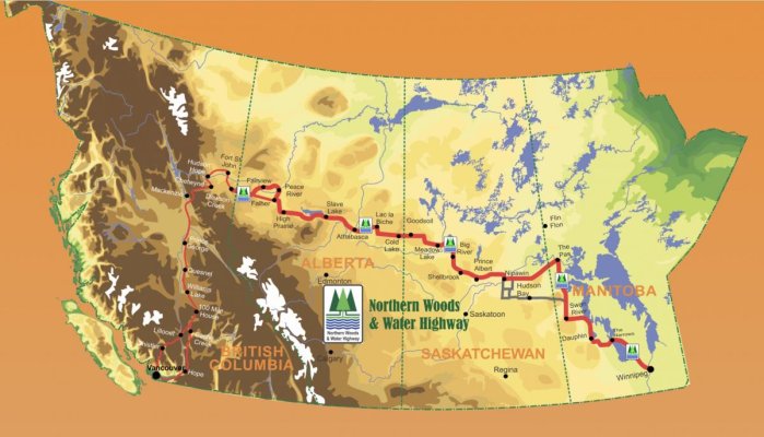
I've been putting Waypoints in my GPS for the Northern Woods and Water Route.
There will be a lot of detours as it goes close to many Provincial and National parks.

I have also been studying my Milepost. Wow is there detail.

I ordered maps and atlases for Canada.
 
This gives a rough idea of the Northern Woods and Water Route

Screenshot%202022-12-05%20154022-L.jpg
 
Vic Harder said:
Do you have place names/Points of interest for those spots? I can speak to some of them for sure.
Heres where I got the info

https://nwwr.ca/3d-flip-book/2021-highway-guide/

and a screen shot of the communities on the route

Screenshot%202022-12-06%20at%2017-18-34%20Communities%20%E2%80%93%20Northern%20Woods%20%26%20Water%20Highway-L.png


There's too many for me to type out.

I had to locate and enter them in Garmin Explorer so I can send them to my Overlander. I don't seem to be able to export a list just a KML or GPX file.
 

Latest posts

Back
Top Bottom