Tri-point advice

Hockey18

New Member
Joined
Jun 19, 2024
Messages
5
Location
Oxford, OH
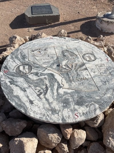
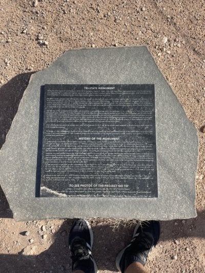
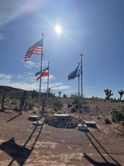
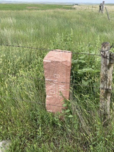
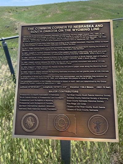
I'm looking to continue my journey to visit the tri-points (and geographical centers) of the west. Had the chance to go to AZ-NV-UT, CO-NE-WY, NE-SD-WY, MT-SD-WY, and MT-ND-SD. Looking to hit the NV ones - CA-NV-OR, ID-NV-OR, and ID-NV-UT. If any of you have made these trips recently, from which direction did you go? I tried the ID-NV-OR trip last year and the path was washed out when I came in from the west (McDermitt), so hoping to try from the south this summer. I got to CA-NV-OR too late in the day, so going to try again but am curious what some of you think.
 
Hummmm......... I was recently looking at CA-NV-OR. That is accessed by a 4.5 hike east from Surprise Valley Road in California. Gaia maps labels it the tri point trail.
 
Thanks! Have been excited to make may trips out west to see the beauty of it all. This was from my trip to AZ-NV-UT. It is a stunning tri-point with a couple different markers. It's fairly easy to access with 4WD, or you can also just take a long hike - but bring plenty of water for this one! I started off I-15 by Littlefield, AZ and made my way through to the this tri-point. The trail is well-marked and I would say easy in relation to elevation gain and terrain.
 

Attachments

  • AZ-NV-UT-1.jpeg
    AZ-NV-UT-1.jpeg
    297.9 KB · Views: 20
  • AZ-NV-UT-3.jpeg
    AZ-NV-UT-3.jpeg
    336.6 KB · Views: 16
  • AZ-NV-UT-9.jpeg
    AZ-NV-UT-9.jpeg
    153.1 KB · Views: 18
Welcome to WTW! I wish I had some helpful info for your quest, but excepting following Google maps during a friend's jaunt to the TX-NM-CO tri-point (which is a few steps off of a public road). I have only the NC-VA-TN tri-point under my belt. That one is notable because it took me three attempts due to trying to access via public land only--but I did find the hardest ways in!
I'd be interested in your experiences in the West, particularly the MT-ND-SD, which I passed by to the east (southbound on Camp Crook Rd) in 2020. I believe its on private property so I'd be interested in how or if you got permission and whether you came in from the Camp Crook Rd side along the ND-SD line, or the MT side off of Webster Rd.
 
Thanks! The NC-VA-TN was tough; the first time I got there too late and did not want to make that hike in the dark. The second time was very easy -- just up the path once I made my way up that dirt road to the final house on the left.

For MT-ND-SD and NE-SD-WY, I contacted the owners and got permission to meet them. In both cases they were VERY nice. In fact, the MT-ND-SD owner met me the morning of July 4 (!) and took me to the spot directly. I had a great time chatting with him about many things, and he could not have been nicer. I went to NE-SD-WY on July 2 (en route to the North American Pole of Inaccessibility) and also had a great conversation with the owner.

If you go to MT-SD-WY, the MT-ND-SD is only about two hours up the road; I approached from Webster Rd.

The CO-NE-WY point is only a couple miles from Panorama Point, the highest point (5259 ft) in Nebraska, but you have to go the long way around since it's in the middle of a bison range!

Hope that helps!
 

Attachments

  • MT-ND-SD-1.jpeg
    MT-ND-SD-1.jpeg
    328 KB · Views: 8
  • NE-SD-WY-1.jpeg
    NE-SD-WY-1.jpeg
    287.2 KB · Views: 9
FYI-A couple of years ago, KNPB. Chanell 5 (PBS) out of Reno, as s part on its' "Wild Nevada" series, went to the Nv, Ca, Or tri corner marker. You might be able to find that program in KNPB's file and stream it or whatever way they keep it open for public access. By the way, that program has some pretty good programs.

Smoke
 
Thanks! The NC-VA-TN was tough; the first time I got there too late and did not want to make that hike in the dark. The second time was very easy -- just up the path once I made my way up that dirt road to the final house on the left.
I actually have two pretty good excuses for failing to reach NC-VA-TN twice. On the first attempt, my geology school buddy (same guy who gained the TX-NM-OK tri-point) started from Pond Mountain Game Land at around 3:00 pm on January 2. We were navigating from old USGS topos which had little detail of the trails and fencelines/woodlines. By the time we figured out where to go without a large elevation loss and gain, it was time to turn around due to impending darkness. The second time I tried it in an absolute tropical downpour accompanied by some non-field oriented friends. We ran out of enthusiasm about halfway there. The third time, geology school buddy and I took our wives on the same roundabout route from Pond Mountain and reached the well-known vandalized house just up the hill from the monument only to find a group of 6 Jeep club travelers who'd driven in from Whitetop Station, VA. While he and I went down the hill to lay hands on the monument. the Jeepers told our wives "it's fine to drive up the private driveway past the house to gain the National Forest Land--everybody does it". Our wives didn't talk much on the way back to the truck at Pond Mountain.
THANKS for the info on MT-ND-SD! Have you done NC-SC-GA yet? I've read a little about it but never tried to reach it.
 
Yes! GA-NC-SC is a great walk through Ellicott Rock Wilderness ... when you get to the spot, the rock where Andrew Ellicott marked the stone is in the river! You will need to get wet to view it, but it's worth it, especially if you are looking to hit this milestone. Hey, nobody ever said exploring was easy! The path will take you to just above the river; you will need to descend about six feet to the water to view the stone!
 

Latest posts

Back
Top Bottom