3 Nights in the Warner Mountains

billr

Contributors
Joined
Feb 28, 2006
Messages
41
Location
Redwood Estates in the Santa Cruz Mountains
Warner Mountains...One of my favorite areas in the state. Been going up there for years. Beautiful scenery, nice hiking, good fishing, and best of all, no crowds!

Now I know, it has been a long time since I have posted on WTW, but it also has been a long time since I have gotten out of town. With a change in employer vacation time has been short.

We spent the first night north of Alturas on the North Fork Davis Creek, near an obsidian dig area. Got a few obsidian needles.

933048243_PLpJA-L.jpg


Spent the next day driving up over the summit and down a spur road.

933048359_eiyTB-L.jpg


933049032_3Eu3m-L.jpg


933048532_ywKq2-L.jpg
 
Thanks for the nice photos and report, Billr.
I've passed through the same area quite a few times, spent the night once or twice, on the way to/from the Black Rock from/to Oregon...but looks like I should make this a destination.
smile.gif
 
Broke camp that afternoon and went up to Patterson camp ground intending to hike the Summit trail the next morning, but found too many ATVs in the camp ground for our liking, so we dropped back down to Mill Creek camp ground.

933047999_ugi54-O.jpg


Next morning was a day hike past Clear Lake and on up to Poison Flat. Not as nice of a hike as Summit would have been, but still nice.

933047900_67RUE-O.jpg


933047621_LU2H2-O.jpg


933047651_yKG3W-O.jpg


933047698_zRjwK-O.jpg
 
Thanks for the nice photos and report, Billr.
I've passed through the same area quite a few times, spent the night once or twice, on the way to/from the Black Rock from/to Oregon...but looks like I should make this a destination.
smile.gif


Yes, this is very much a destination. There is a lot more to see if you get off the highway between Alturas and Cederville. :)

And a lot cooler this time of the year than Black Rock...
 
Nice report, Bill. Very impressive waterfall. We were planning to do the Warners a few weeks ago but had to cancel. Will probably try again soon, maybe Labor Day weekend. Any suggested routes, maps, or must do spots?
 
Very nice photos and trip report, makes us want to visit up there. Thanks! We especially like the photo of the lily with the lupine leaves.
 
Nice trip report. Haven't been up that way in thirty years. Backpacked a little but never did really explore the area. May have to remedy that.
 
Nice report, Bill. Very impressive waterfall. We were planning to do the Warners a few weeks ago but had to cancel. Will probably try again soon, maybe Labor Day weekend. Any suggested routes, maps, or must do spots?


Ted,

While I am not an expert of the area, I have been there over a dozen times over the past 25 years. I have been over the Highgrade road, backpacked in the South Warner Wilderness, and been fishing at Blue Lake many times.

The Warner's are divided North and South by highway 299 which runs between Alturas and Cedarville. I find the North is better for fun vehicle travel, where the South is better for hiking trails in the wilderness area. I like both for different reasons.

South%20Warner%20Vicinity.jpg


This trip I tried to get into some areas that I have not covered before. I have to admit that I used a few interesting sounding Geochaches to find some nice areas to explore.

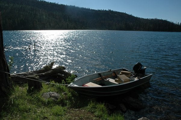
The Highgrade Road from 395 to Fort Bidwell is a nice drive with lots of history. Dismal Swamp road off the Highgrade up to Oregon is an excellent drive. Hikes out of Pepperdine camp into the wilderness are great. And like I said I enjoy pulling my boat up to Blue Lake for a few day of fishing. You would not be disappointed with any of these or anywhere else.

For maps, I use a combination of Forest Service maps and Topo maps.

Warner Mountains in California are in the Modoc forest. Maps are on line or at an office in Alturas or Cedarville.

On line -
http://www.nationalforeststore.com/merchant.mvc?Screen=PROD&Store_Code=NFS&Product_Code=CA-10&Category_Code=CA

You may also want the Fremont map if you cross over the border into Oregon.

http://www.nationalforeststore.com/merchant.mvc?Screen=PROD&Store_Code=NFS&Product_Code=OR-6&Category_Code=OR

I also have a copy of National Geographic Topo! California that I use for planning, but do not like to take my laptop with me on trips.

If you are looking for hikes, I would also get a copy of the South Waner Wilderness map -

http://www.nationalforeststore.com/merchant.mvc?Screen=PROD&Store_Code=NFS&Product_Code=CA-45&Category_Code=CA

Bill
 

Attachments

  • DSC_0021.jpg
    DSC_0021.jpg
    172.2 KB · Views: 104
Bill,
Thanks for sharing all the detail information! I'm going to plan a trip to that area.
Alex
 
Very beautiful pictures. I was showing my wife last night and she really liked it. we may have to plan something either in the fall or next spring.
 
Bill,

Great report and pics! I am planning on going there in a couple weeks. Can you think of any spots where a group of up to 5 vehicles would be able to camp? Hoping to find some flat ground to camp in that is not an official campground so that some of our less civilized members don't keep the entire campground awake :)


DD,

That is not an easy request. Ever area I have been to recently is either been too steep or too fragile for that size of group.

There are some areas south of Blue Lake, but they were effected by the Blue Fire of 2001 and still showing it. There is an undeveloped camp at the Pink Lady obsidian digs that is nice, not a sole there last week when we passed through. I stayed at Willow Creek cg north of the border in Oregon back in 2002 and looked as if no one had stayed there for a decade or two. There is a spot at Dismal Creek, but both times I have been through there it was taken. Otherwise every spot I have stayed would only be good for maybe two rigs at most. I would expect to find logging staging areas at the end of most spur roads in the lower areas, but they tend to ugly from the logging operations. I would stay off the meadows in the high country as they are fragile.

There are a lot of spur roads off the Dismal Creek road. I think if I was leading that group I would take the Highgrade road up and go north past Dismal Creek toward the border. I would think you would find something there. But then again it has been 8 years since I have been through there and the memory does not serve me as well as it use to... :)
 
Very beautiful pictures. I was showing my wife last night and she really liked it. we may have to plan something either in the fall or next spring.


I would not try too early in the spring as you may not be able to get in the high country. That is where the Warner's are the nicest. While we had clear roads this past week, there was still snow just off the road side in spots that looked to have just cleared. I was told at the Davis Creek store that we would not make it to the top. Guess their info was a bit old.
 

New posts - WTW

Back
Top Bottom