Dolores River Headwaters, CO

Steve Scearce

Contributors
Joined
Sep 12, 2009
Messages
155
Location
Durango, Colorado
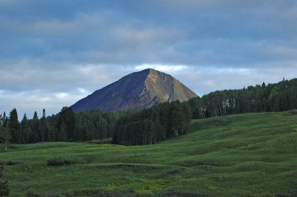
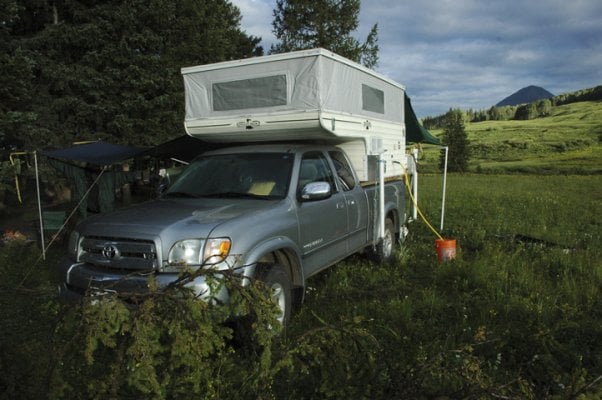
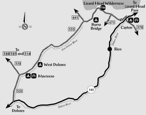
Despite flash flood warnings throughout SW Colorado, we headed up to the headwaters of the West Fork of the Dolores River near Rico, CO last Friday with our pals Jerry and Charlotte. They were in a Dodge Ram Dually with a Giant Lance camper and we were in our Tundra with our Phoenix pop-up. The six-mile drive in on Forest Service Road 535 from Colorado Hwy 145 between Rico and Trout Lake was wet and somewhat slippery, but not bad. 4wd was nice under the wet conditions, but dry, the road would work for a high-clearance 2wd vehicle.

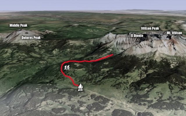
We had originally intended to camp at the Navajo Lake trailhead, after I did some Google Earth recon and noticed lots of nice meadows right off the trailhead spur road. We got there and realized the limitations of Google Earth: what appeared to be flat meadows were in fact 30-40 degree slopes. With fading daylight, we backtracked on the FS road to the Kilpacker trailhead about a mile back. The spur road to the trailhead had several nice campsites in a clump of spruces, so we pulled in and immediately deployed our awnings on the passenger side and back of the campers. If the weather turned to crap, we'd have a place to enjoy an adult beverage or three by the campfire.

DSC_5717.jpg
 
Saturday morning we got up around 6:30 am and wolfed down a quick breakfast before hitting the Kilpacker Trail. Given the forecast, we wanted to reach our high point of Kilpacker Basin at the base of El Diente before 11 am. It was a leisurely 3 mile hike in to the basin.
 

Attachments

  • kilpacker-trail.jpg
    kilpacker-trail.jpg
    284.4 KB · Views: 199
El Diente (14,159 ft) was in and out of the clouds by 11 am. We enjoyed the view of Kilpacker Falls from a high meadow, had a snack, and headed back to camp.
 

Attachments

  • DSC_5729.jpg
    DSC_5729.jpg
    314.3 KB · Views: 133
About halfway back to camp, it started to rain... gentle at first, then full-on downpour for the duration. We got back to camp drenched – my Gore-Tex jacket failed miserably – and hunkered down in the campers until it let up in the evening.
 

Attachments

  • DSC_5765.jpg
    DSC_5765.jpg
    425.7 KB · Views: 192
We enjoyed dinner and cocktails around the fire and retired early. We awoke Sunday morning to partly cloudy skies and had a leisurely breakfast around the campfire.
 

Attachments

  • DSC_5775.jpg
    DSC_5775.jpg
    342.9 KB · Views: 141
Our friends were in somewhat of a hurry to break camp and head down the Dunton Road before things turned sloppy again. Jan and I took our time. We broke camp and drove down the road that steadily improved in quality to graded gravel past the once-infamous ghost town of Dunton, now a privately owned rustic enclave for the extremely well-healed. I stopped at a nice spot along the West Fork of the Dolores River to cast a few flies to what I assumed would be eager and somewhat naive high-altitude trout. The water looked fishy, albeit a little off-color from the rains, but I couldn't scare a fish, let alone catch one. We continued on down the road past beautiful ranches until we reached Hwy 145.

This area was new to us, and we will return to explore it further. Lots of Forest Service roads spurring off the main Dunton Road, and lots of gorgeous high country to hike in the Lizard Head Wilderness.
 

Attachments

  • DSC_5833.jpg
    DSC_5833.jpg
    393.5 KB · Views: 166
DurangoSteve, thanks for the photos and report on your adventure! Gives us ideas on new places to explore, we'll be looking at our maps. Those drenching rainstorms can be a nuisance, but they do make the Rockies the Rockies. Ditto on your experiences with rain jackets. Ours got a hell of a work out........
 
Nice report. Thanks.

I've been looking into the Delores River area lately, mostly as a mountain biker, also as a hiker.
What was your travel time from, say, Hesperus, as I would be coming in from the south on the La Plata highway?
What would you suggest would be the latest one could get in there? I completely understand that early snows happen but would this be a place you could still get to in late September?
 
Colorado has some gorgeous country!!! I am hoping to get down there next month for some explorations of my own!!!

Great job!! Thanks for posting!!! :cool:
 
Nice report. Thanks.

I've been looking into the Delores River area lately, mostly as a mountain biker, also as a hiker.
What was your travel time from, say, Hesperus, as I would be coming in from the south on the La Plata highway?
What would you suggest would be the latest one could get in there? I completely understand that early snows happen but would this be a place you could still get to in late September?


From Durango, it was about two hours highway time to the FS road turnoff past Rico. It was another 25 minutes (6 miles) to the Kilpacker trailhead. FS Road 535 is 32 miles long. If you were to come up that road from the south (vs. driving the hwy past Rico) I'd add another 30 minutes driving time. Too much info? I'd say from the junction of the La Plata Hwy and US 160, allow 2+ hours.

There's lots of mountain biking to be done in that area... except, of course, in the Lizard Head Wilderness.

Late September should be fine, with a chance of snow. You'll be into archery season, so there will likely be a few hunters in the area. I'm sure in October and November the bullets are flying up there!
 
Thanks for the report and photos, Durango. That looks like a place I should visit as I seek out CO's 14ers. With all that rain, I'd have guessed that I was camped somewhere near by. :)

Stew
 
Thanks for the report and photos, Durango. That looks like a place I should visit as I seek out CO's 14ers. With all that rain, I'd have guessed that I was camped somewhere near by. :)

Stew


Yep, that'd be the basecamp if you want to bag the two Wilsons and El Diente.

So you're a rainmaker? :cool:
 
Yep, that'd be the basecamp if you want to bag the two Wilsons and El Diente.

So you're a rainmaker? :cool:


Yep, just ask 3pin and his lady.

El Diente--The Tooth--that sounds ominous!
 
Yep, just ask 3pin and his lady.


Yup, "Mr. Rain" we call him. He does such a good job that it follows you for 8 days or so after you part company with Stew!
 
Yep, just ask 3pin and his lady.

El Diente--The Tooth--that sounds ominous!


El Diente has a pretty serious reputation. It's not an "official" 14er, and I hear that the ridge separating it and Mt. Wilson is pretty nasty: Rotten rock, big exposure and 4th class complications. Not on my list. Nearby Dolores Peak (13-something) looks way more pleasant to me!
 

New posts - WTW

Back
Top Bottom