This is a report based on my questions posted in "Trip Planning" with same topic.
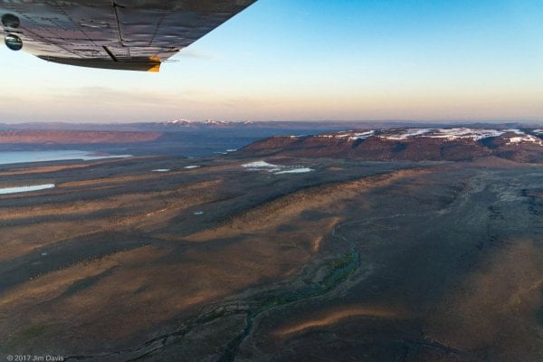
[SIZE=10pt]Left Enterprise 10/24 and spent night at Page Springs Campground and had dinner at Frenchglen Hotel. Next day stopped at Hart Refuge HQ and chatted with Habitat Biologist and Ranger. Told them of my plans to drive South and exit at Hwy 140 and was told no gates would be closed until 12/1 and that I would only have one water crossing [“and it would have a rock bottom”] while driving the ‘South Boundary Road’ [Guano Creek Rd] to the southern end of the Refuge at Jacobs Reservoir . Spent night at Hart Refuge Hot Springs CG; very nice area and next morning drove out South on the Blue Sky Rd and then West onto the Skyline Rd and up and over to South on Barnhardy Rd and along Guano Creek. Stopped at old Camp Warner and honored the two grave stones of army Cpls dated 1866 and 1867. Both had fresh American flags. Kept going since canyon was not best for my solar system on the FWC Hawk. All went well but slow, average speed 2-5 mph or slower crawling over volcanic rock,and just past the Long Lake turn off I came to the “only” water ford the staff had mentioned. My ’05 Tundra AC SR5 has my new Warn 8S Multi-Mount winch in the front receiver so the 2 foot + vertical berm on the exit end above the water of a long [40+ feet] trough of water/mud was a concern. No drive arounds. Four wheel Hi/Toyo AT II. First 5 feet had rock but then only soft stuff. Water was up to 2+ feet deep and I had to end up charging the exit point at an angle to clear the winch/axle when going over the exit berm. OK, got through but forgot to roll up the windows and water came onto hood and a little in through the windows. No bigee, but what waited for me about 1/8 mile further was. Driving in a reed marsh and came around a left hand curve to see 3 sections of obviously rutted out tracks of mud covered in water with perhaps 4 feet between them and bound on both sides by 3-4 foot high reeds. Crap. Decision point. Turn around or attempt it. Knowing that getting bogged in would mean the truck and camper would probably stay there for the winter and a long hike out for me. The last of the three sections of mire also had an at least 2.5 foot vertical berm above the water at the exit. Ok, slow entry, then felt nothing but ooze and I ramped up the speed, sliding and slopping through the first two that had 2 feet of water over rutted mud. Focused on the exit berm when entering the third submerged [2.5+ feet water in this one] mud trough; damn berm looked like a mountain, so I put my right front wheel on the center of the exit berm [which had ruts on right and left] bounced the Tundra/Hawk up and over. Pucker time, not a nice feeling. But it is better to be lucky than good. Thinking I was home free I got about 2 miles from Jacobs Res and guess what, another and more complicated water/mud/berm tank trap. The initial 30+ feet was mud with 2 feet of water, with a 3 foot exit berm at the far right corner edge and a 3+ foot berm across the center of the “road” with a 3-4 foot drop past that berm into deep mud tracks which continued for 50+ feet up the center inside steep vertical side walls. Hell, even a military Humvee would not get out up the center route. Again no alternate ways around these obstacles; only a faint set of tracks beyond the right side corner exit berm that eventually gained dry ground. Only option. No finesse just a slam bang spinning crawl up right side corner exit berm with a last second slide of rear end toward the deep recesses of the center track. Flailed on and brought rear of truck with me to dry ground. Time to change shorts.[/SIZE]
[SIZE=10pt] [/SIZE]
[SIZE=10pt]Will cut this missive off. [/SIZE]
[SIZE=10pt]Night at Jacobs Res was very cool and road to Shirk Ranch [interesting site] was slow and rocky but fun. Next night at Sheldon [/SIZE][SIZE=13.3333px]Refuge [/SIZE][SIZE=10pt]Virgin Valley CG and hot springs was great; well, after I got the hunter to shut down his generator and the guy from Reno to quiet his staked out barking [coyote bait?] dog about 2200 hrs. From there north along East Steen Rd and from Burns to Seneca to Prairie City to Sumpter to Starkey I began to encounter tons, no thousands, of elk hunter encampments in every CG or possible dirt side road. After the solitude [never saw another person from Hart Refuge CG to Hwy 140], peace and quiet, for me the hunters were a huge put off so I went home three days early. One day after arriving home early I took my Bride into the ER at hospital at 0600 hrs and she had an emergency appendectomy at 1030 hrs. [/SIZE]
[SIZE=10pt]Like I said, tis' better to be lucky. [/SIZE][SIZE=10pt] [/SIZE]
[SIZE=10pt]Phil[/SIZE]
[SIZE=13.3333px]'05 Tundra/ '16 Hawk[/SIZE]
[SIZE=10pt]Left Enterprise 10/24 and spent night at Page Springs Campground and had dinner at Frenchglen Hotel. Next day stopped at Hart Refuge HQ and chatted with Habitat Biologist and Ranger. Told them of my plans to drive South and exit at Hwy 140 and was told no gates would be closed until 12/1 and that I would only have one water crossing [“and it would have a rock bottom”] while driving the ‘South Boundary Road’ [Guano Creek Rd] to the southern end of the Refuge at Jacobs Reservoir . Spent night at Hart Refuge Hot Springs CG; very nice area and next morning drove out South on the Blue Sky Rd and then West onto the Skyline Rd and up and over to South on Barnhardy Rd and along Guano Creek. Stopped at old Camp Warner and honored the two grave stones of army Cpls dated 1866 and 1867. Both had fresh American flags. Kept going since canyon was not best for my solar system on the FWC Hawk. All went well but slow, average speed 2-5 mph or slower crawling over volcanic rock,and just past the Long Lake turn off I came to the “only” water ford the staff had mentioned. My ’05 Tundra AC SR5 has my new Warn 8S Multi-Mount winch in the front receiver so the 2 foot + vertical berm on the exit end above the water of a long [40+ feet] trough of water/mud was a concern. No drive arounds. Four wheel Hi/Toyo AT II. First 5 feet had rock but then only soft stuff. Water was up to 2+ feet deep and I had to end up charging the exit point at an angle to clear the winch/axle when going over the exit berm. OK, got through but forgot to roll up the windows and water came onto hood and a little in through the windows. No bigee, but what waited for me about 1/8 mile further was. Driving in a reed marsh and came around a left hand curve to see 3 sections of obviously rutted out tracks of mud covered in water with perhaps 4 feet between them and bound on both sides by 3-4 foot high reeds. Crap. Decision point. Turn around or attempt it. Knowing that getting bogged in would mean the truck and camper would probably stay there for the winter and a long hike out for me. The last of the three sections of mire also had an at least 2.5 foot vertical berm above the water at the exit. Ok, slow entry, then felt nothing but ooze and I ramped up the speed, sliding and slopping through the first two that had 2 feet of water over rutted mud. Focused on the exit berm when entering the third submerged [2.5+ feet water in this one] mud trough; damn berm looked like a mountain, so I put my right front wheel on the center of the exit berm [which had ruts on right and left] bounced the Tundra/Hawk up and over. Pucker time, not a nice feeling. But it is better to be lucky than good. Thinking I was home free I got about 2 miles from Jacobs Res and guess what, another and more complicated water/mud/berm tank trap. The initial 30+ feet was mud with 2 feet of water, with a 3 foot exit berm at the far right corner edge and a 3+ foot berm across the center of the “road” with a 3-4 foot drop past that berm into deep mud tracks which continued for 50+ feet up the center inside steep vertical side walls. Hell, even a military Humvee would not get out up the center route. Again no alternate ways around these obstacles; only a faint set of tracks beyond the right side corner exit berm that eventually gained dry ground. Only option. No finesse just a slam bang spinning crawl up right side corner exit berm with a last second slide of rear end toward the deep recesses of the center track. Flailed on and brought rear of truck with me to dry ground. Time to change shorts.[/SIZE]
[SIZE=10pt] [/SIZE]
[SIZE=10pt]Will cut this missive off. [/SIZE]
[SIZE=10pt]Night at Jacobs Res was very cool and road to Shirk Ranch [interesting site] was slow and rocky but fun. Next night at Sheldon [/SIZE][SIZE=13.3333px]Refuge [/SIZE][SIZE=10pt]Virgin Valley CG and hot springs was great; well, after I got the hunter to shut down his generator and the guy from Reno to quiet his staked out barking [coyote bait?] dog about 2200 hrs. From there north along East Steen Rd and from Burns to Seneca to Prairie City to Sumpter to Starkey I began to encounter tons, no thousands, of elk hunter encampments in every CG or possible dirt side road. After the solitude [never saw another person from Hart Refuge CG to Hwy 140], peace and quiet, for me the hunters were a huge put off so I went home three days early. One day after arriving home early I took my Bride into the ER at hospital at 0600 hrs and she had an emergency appendectomy at 1030 hrs. [/SIZE]
[SIZE=10pt]Like I said, tis' better to be lucky.
[/SIZE][SIZE=10pt] [/SIZE][SIZE=10pt]Phil[/SIZE]
[SIZE=13.3333px]'05 Tundra/ '16 Hawk[/SIZE]