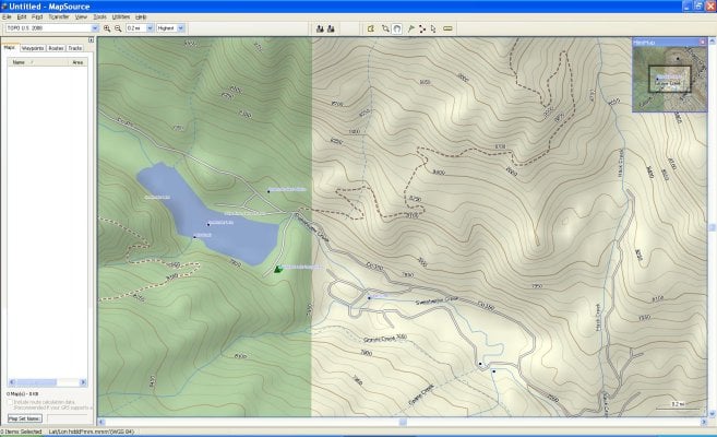
So I just took the plunge out of the dark ages and finally got myself a GPS (Garmin 60CSX) which should be here today. Forgive my ignorance on the subject but I'm totally clueless and trying to find the best way to go. A few questions:
1. Should I plan on buying the Mapsource software or does it come with the unit?
2. Is it worth the $ to buy the Garmin Maps or NatGeo Maps? I've seen some references to GPSfiledepot or free maps, etc., are they the way to go. I don't mind spending the $ on the good stuff if it is truly worth it.
3. For Baja folks, I hear LBMaps is the way to go, any experience here? Also Bicimapas? Any opinions on the two?
4. Is it best to buy multiple memory cards? For example one card for California, one for Nevada and then one for Baja and then use the appropriate card for each location? Is this the best way to manage multiple states/areas?
5. I've read debates about going with 2GB or 4GB (even 8G

cards with these units, is 4GB overkill? Referring to Question #4 it seems like it would be easiest to have a separate card for each area but maybe not? Not sure how the GPS unit selects/reads the data off the cards.
What say you gurus out there? Let me have it. (probably should have made this it's own thread)
SunMan,
The decision on which software to purchase for interfacing with your gps depends on what you are trying to accomplish. I am a hunter and have used USGS Topographical maps (1:24,000) my entire life. I love the detail they provide. If you are used to using USGS topo maps you will not be satisfied with the Mapsource software (ie. using maps printed using Mapsource). The Mapsource software, however is indispensable for making base maps for loading into your gps.
I use the Mapsource software (both original 100K and additionally the Southwest US 24K) for base maps in my GPS units; and use the National Geographic Topo software for printing REAL USGS guality topo maps (1:24,000) to carry in the field. Both products interface directly with your GPS unit (waypoints in/out etc.).
Do not rely solely on your gps for navigation in the field. Always carry a map and compass and learn how to use them in case your GPS goes down.
Mapsource:
Mapsource software comes standard with (1:100,000 detail for West US, East US, Alaska and Hawaii): I bought the standard Mapsource software and installed it on my pc. When I run the Mapsource software there is a pull down menu at the top that shows 4 choices (West US, East US, Alaska, Hawaii) as choices. The 100K level of detail is not much good on a handheld GPS since the screen is so small....so I purchased the Mapsource TOPO U.S. 24K Southwest DVD (slightly over $100) to provide the 24K detail (for the Southwest US states).
It is confusing the way Garmin packages the Mapsource software. When I installed the Mapsource TOPO 24K Southwest software it just interfaces with the original Mapsource (100K) install (ie. there is not another separate software product on your computer)....so when you run the Mapsource software, the pull down menu at the top, the original 4 items show up (West US, East US, Alaska, Hawaii) ....but now there is also a menu choice for "Topo US 24k. Southwest". If you do the selection properly you can create basemaps for an entire state....or a number of states. I was originally going to make a basemap for each state...but that would require a separate chip for each state (per gps unit) ....so I made a mapset for 4 states and downloaded it in one chip. Warning....if you are making a mapset for several states....it takes a long time. The software just sits there crunching for hours...but it will eventually create the mapset you want. You can then copy the mapset to any number of chips. Be sure to save off the huge mapset you just created for future use so you don't have to ever create it again.
National Geographip Topo:
I love this software for producing top quality USGS topo maps in 24k scale. I print them on Adventure Paper:
http://www.amazon.co...r/dp/B00005OMZ9 to produce waterproof quality maps. This is not really paper...but a plastic material that is unbelievably durable (you can print on both sides). The quality of these maps are better than original USGS 24K topo maps. This software is purchased for each state you wish to roam for about $49 per state.
You may not wish to buy that much software....it all depends on what level of detail you need or want. I love having the 24k mapset loaded onto my GPS units AND having the detailed 24K USGS Topo maps to navigate with. Sorry this reply is somewhat long winded but it is a difficult topic to cover with just a few sentences. This may be more information than you wanted.


