ID-MT-WY?: Desert Rat Venturing Outside His Comfort Zone Seeks Input

But wait, there's more............................

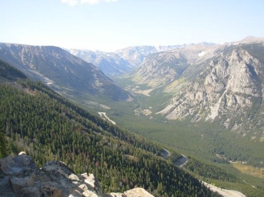
I've never been there, but the Big Belt and Little Belt Mountains, generally north of I-90 and east of I-15 in the White Sulphur Springs area, look mighty nice. Lewis & Clark NF is the FS unit there.

I mentioned Philipsburg, and while I believe you're not crazy about towns and their populations, you might can make an exception for Philipsburg. Good food, good ice cream and fudge, and great folks, all in a very nice little town. Above P'burg is the ghost town of Granite. It's a steep and fairly narrow graded gravel road up there, but I took my Ford up there without a problem or concern. People drive cars up there every day, so it's not rough. There's walking tour of the townsite and a load of mining ruins.

On the east end of Anaconda, the smelter structures are still there and some are being used for metal fabrication work nowadays. The 585' tall smelter smokestack still stands and can be seen for many miles around.

From a point near the stack, MT 569(?) runs south, over the Divide (with some exceptional views just on the far side of the Divide), down to the Big Hole River/MT 43 a few miles west of the village of Wise River. If you're headed from Rock Creek or Philipsburg towards the Big Hole or the Pioneers, this is your route.

From MT 43 east of Wise River, Quartz Hill Rd runs up a few miles to Vipond Park. Vipond Park is a park in the sense that the term applies to an open, upland plain surrounded by mountains. Vipond Park is a true hidden gem and lies within the Beaverhead-Deerlodge NF, so disbursed campingis available most anywhere. Travel the main road for 3-4 miles through and across the park to where it reaches a bluff overlooking Canyon Creek. The road becomes a shelf road there but wil easily carry your rig to the floor of the Canyon Creek Valley. Canyon Creek is a box canyon, so head downstream, past Canyon Creek Cabin, past the "beehive" charcoal kiln structures so well preserved, to and through the former smelter town of Glendale, and finally to the Big Hole River crossing at Melrose, astride I-15.

Up the Byway from the village of Wise River, Mono Creek CG is a nice spot and is close to the ghost town of Coolidge. Coolidge is a well-preserved ghost town and the remains of the mill built to treat the ores are huge and impressive. Note that you can see the shorn-off side of Comet Mountain from Coolidge.

In Butte you can see the Berkeley Pit, one of the largest open-pit mines on Earth. It's slowly filling with water and can be viewed from a deck which has a small gift shop/museum attached.

Also in Butte you can visit the very nice mining museum. For rockheads like me, especially hard-rock mining rockheads, the museum is a must-see. Loads and loads of Butte history/miners union history, and general "Copper Baron" mining history there.

Up towards Glacier is Choteau, where you may bump into David Letterman in town while at his ranch nearby. The town of Augusta is nice and off the beaten path along US 287.

You can cross the Divide west of Augusta on MT 200 and pass through Lincoln, MT, the last home of the Unabomber. The road follows the Blackfoot River down to I-90 east of Missoula. The Blackfoot is the "A River Runs Through it" stream.

Browning, MT is close to East Glacier and is home to the Blackfeet Indians. The Museum of the Plains Indian is in Browning, and like the Big Hole National Battlefield, is a sobering place to visit. The Blackfeet are, generally speaking, unfriendly towards visitors, and after spending some time at the Big Hole Battlefield and the Museum in Browning, one can imagine why.

Between Glacier and Missoula is St Ignatius, a mission complex. I believe Mission Lake is on Reservation land off to the east side of US 93, but the only time I was there camping was in the late 1970s, a time frame sometimes tough to recall details about. I do recall it was a beautiful, forested lake, the beers cold, and the locals friendly.

Missoula is easily my favorite town in Montana outside of Philipsburg. Home to the University of Montana, it's a free-spriit libertarian city with the Clark Fork River running right through the center, separating the downtown from campus. Walking and cycling paths line the river, several footbridges cross it, and some really great restaurants, cafes, coffeshops, bookstores, and bars are all within a short walk of the motels on Broadway. I particularly like The Oxford, a diner which has no locks on the doors because they never close. They serve an eclectic mix of Americana and still use a pidgin-English style ordering system which is a scream to listen to. Missoula also has a Costco and a huge big-box sporting goods store (Academy?), and an REI store.

A last reference to a route to travel is the Skalkaho Highway, MT 38, running E-W from Hamilton in the Bitterroot Valley to Philipsburg in the Flint Creek Valley. From Hamilton east to the pass, it's mostly graded gravel and the uppermost 3-4 miles feature a no-guardrail drop-off down 800-1,000' to the valley below. Throw some active logging truck activity in there and it's a real thrill to drive. From the pass eastward, it's paved, and there's a nice NF campground and probably much in the way of disbursed camping in the same vicinity. From the foot of the range east of the pass, the southernmost section of Rock Creek Road traverses some wide-open floodplain with some large ranches and a particularly hoity-toity resort before reaching MT 348 and the lower section of Rock Creek Rd at MP 41, 41 miles from I-90.

Foy
 
Foy I am not making this trip but you sure have put a lot of future info out.Some of what you have written about I have traveled through,not knowing any thing about those areas until now.
Thanks for the great info.
Frank
 
Casa Escarlata Robles Too said:
Foy I am not making this trip but you sure have put a lot of future info out.Some of what you have written about I have traveled through,not knowing any thing about those areas until now.
Thanks for the great info.
Frank
Go for it, Frank.

It seems that much of the tourist traffic in Montana travels I-90 between Yellowstone and Glacier, and to similar degree, US 287 from I-90 to East Glacier. The swath of southwest MT west of YNP, south of I-90, and up against the ID border ridge is pretty well devoid of out-of-staters. The whole of the Beaverhead-Deerlodge NF, all 3.2 million acres, is relatively free of out-of-staters. You'll see some locals horse-packing where allowed, some locals fishing here and there, but for the most part, you've got the place to yourself.

Oh, and speaking of US 287 and I-90, where they cross west of Bozeman is the community of Wheat, MT. A superlative baked goods and coffeeshop is right on the interchange, and you can buy small quantities of specialty flours and baking supplies in their store. Yeah, you'll be sharing the place with some East Coasters wearing sandals with black socks, but the food and coffee is worth it.

Foy
 
Casa Escarlata Robles Too said:
Once again thanks Foy.
I have noticed that the area you are talking about,Beaverhead-Deerlodge NF doesn't have many people around.
Frank
That's for sure, Frank. Neither Missoula nor Butte are high population cities, and the largest city in the state, Billings, is 250 miles from Dillon. Local Montana weekenders from any of the 3 cities would drive past other very nice places to ride, hike, and camp to reach the Big Hole and the Pioneers, so the areas hard by the ID border, which are another 60-80 miles from Dillon, are quite free of visitors, or at least, from hordes of visitors.

Foy
 
We're leaving for a similar trip this Saturday. Heading to Dinosaur National Monuent on the Utah side first. Then up to Grand Teton and Yellowstone. Making a brief stop in Bozeman to see the Musuem of the Rockies for more dinosaur stuff for our 5 year old then up to Glacier.
 
Personally, I'll never go to Glacier, YNP/Tetons again during the summer. The crowds were unreal. No parking available at just about every main attraction....circling to find a spot at Old Faithful. I knew this going in but still was surprised. Love those parks, but for me, only spring and fall when school is back in session and the hordes have departed.

The best parts of my three week trip through CO, WY, and MT were the out of the way places....many of which were mentioned in detail by Foy.

Some other secluded spots.
Big Horn mountains and Medicine Wheel in WY. Campground all to ourselves....never saw another soul.
nLcMPfG.jpg

69JaNN4.jpg

hyMny1z.jpg


Ennis and Quake Lake MT.....one other camper in this campground along the Madison river.
dmorFk9.jpg

53ciWcO.jpg

On a somber note, 28 campers still buried under this slide from a 7.5 earthquake in 1959.
Very interesting area and only an hour from the crowds in West Yellowstone.

The backroads are your friend.
 
MarkBC said:
Help, please: :)
I'd like suggestions from WTWers for places I should go/see/stay on a visit to the area, roughly, circled in the map below:

northern-rockies-01.jpg

(maybe the circle should be extended a bit further south into central Idaho -- imagine that I've drawn it so)

The mid-'90s was the last time (and to a large extent the only time) I've visited the area I'm considering visiting again, and that previous trip was a mostly-driving whirlwind road-trip tour (camping out of the back of my '92 Toyota pickup).

I'm mostly interested in input about areas not in the national parks. I may not even visit them this trip, except perhaps cutting across the northern tier of Yellowstone after crossing Beartooth Pass (as I did on that '90s trip).
I found the area around Beartooth pass amazing, and I told myself that I'd be back to explore; that was almost 20 years ago. :rolleyes:
OK...and Glacier's Going to the Sun Highway was so world-class fantastic on that '90s trip that I could easily repeat that part, too.

But aside from the obvious (the national parks), what's cool to see? Or if not especially cool, what's nice, pleasant to visit?
Limitations/Qualifications: 1) I'm not going to do any river trips. 2) I'm probably not going to do any backpacking...unless absolutely necessary. That is, I'd rather do a 20-mile day hike to see something cool than two 10-mile backpack days. But I couldn't rule it out.

I've found that I don't have an image/model/map in my head of this area and its features for planning purposes (as I do for most of Nevada and Utah and Arizona and southeast California) so I'm really starting from scratch, from newbie ignorance, for any non-national-park stuff :unsure: ... Of course I have Benchmark Atlases for ID, MT, WY, and WA...but I know very little about what I'm looking at.
And so, I'd like suggestions for nice places to see and stay, nice routes to take to get there and around.

I'll be driving my F250 with FWC Hawk.
I'm considering doing this trip soon -- like, early/mid August and spend 2 weeks-ish out there.

Thanks. :)
Montana's great ! Don't over look Eastern Washington, North Eastern Oregon and the Idaho panhandle. Snake, Salmon and Clearwater River canyons area have a lot to explore. Pass on the Magrudor Road hipe, it's an internet thing. Follow any of the river roads, that's where the histroy is. But in general just explore, it's all good. Couple quick examples of my fav's, Riggins, Id. to McCall thru Burgdorf or Pierce, Id. to Superior, Mt. . See Imnaha, Or., Republic, Wa., Avery, Id., Yaak, Mt. I lived in Spokane,Wa. for 24 years exploring by 4x4 and D/S motorcyle. Man I miss the PNW in summertime.
 
JHa6av8r said:
We're leaving for a similar trip this Saturday. Heading to Dinosaur National Monuent on the Utah side first. Then up to Grand Teton and Yellowstone. Making a brief stop in Bozeman to see the Musuem of the Rockies for more dinosaur stuff for our 5 year old then up to Glacier.
If you have been to Yellowstone/Teton,than disregard this info.
In Teton the Gros Ventre campground is nice,lots of room and you might see moose there.Also go to the Rockefeller center past the visitors center and take the short hike to Phelps Lake.It's a nice walk through a special part of the park.The views are great of the lake and there might be moose there.The other campgrounds at Teton are either tent only or by Jackson Lake.
Than the Flagg Ranch/Grassy Lake road at the north end of the park has some nice sites just a few miles out on the road. # 3 is one we checked out that was very nice.There are 14 sites first come first serve,free.
In Yellowstone,if you can get there early try Slough Creek and Pebble Creek campgrounds.They are in the best animal viewing area of the park.What we usually do is camp at Madison or Indian Creek or Norris than get out of camp early about 6 am,and head to the Lamar Valley and try to get a site at Slough or Pebble.Also try to get over Dunraven Pass early in the morning,you might get to see some grizzles up there.
In Glacier try the lakes Bowman or Kinta on the west side.Usually not many people there.Also some nice walking trails.
Have a great trip.
Frank
Some pictures.
Phelps Lk .Bowman Lk. Grizzly bear on Dunraven Pass
 

Attachments

  • DSCN2044.jpg
    DSCN2044.jpg
    60.2 KB · Views: 229
  • DSCN2060.jpg
    DSCN2060.jpg
    44.5 KB · Views: 160
  • DSCN2094.jpg
    DSCN2094.jpg
    39.6 KB · Views: 152
  • DSCN2103.jpg
    DSCN2103.jpg
    58.3 KB · Views: 144
  • DSCN2234_2.jpg
    DSCN2234_2.jpg
    60.9 KB · Views: 140
  • DSCN2739.jpg
    DSCN2739.jpg
    83.1 KB · Views: 148
  • DSCN2740.jpg
    DSCN2740.jpg
    96.3 KB · Views: 150
Casa Escarlata Robles Too said:
If you have been to Yellowstone/Teton,than disregard this info.
In Teton the Gros Ventre campground is nice,lots of room and you might see moose there.Also go to the Rockefeller center past the visitors center and take the short hike to Phelps Lake.It's a nice walk through a special part of the park.The views are great of the lake and there might be moose there.The other campgrounds at Teton are either tent only or by Jackson Lake.
Than the Flagg Ranch/Grass Lake road at the north end of the park has some nice sites just a few miles out on the road.
In Yellowstone,if you can get there early try Slough Creek and Pebble Creek campgrounds.They are in the best animal viewing area of the park.What we usually do is camp at Madison or Indian Creek or Norris than get out of camp early about 6 am,and head to the Lamar Valley and try to get a site at Slough or Pebble.Also try to get over Dunraven Pass early in the morning,you might get to see some grizzles up there.
In Glacier try the lakes Bowman or Kinta on the west side.Usually not many people there.Also some nice walking trails.
Have a great trip.
Frank
Some pictures.
Phelps Lk .Bowman Lk. Grizzly bear on Dunraven Pass
Thanks for the information. Gros Ventre is my planned stop after leaving Dinosaur National Monument at least for the first night. Flagg Ranch/Grass Lake Rd also got my interest. I thought Lizard campground would be nice. I had noted to arrive early at both Slough and Pebble in my planning. We'll deal with the crowds but it should still be fun. Thanks again.

John
 
John,I think you would like the Flagg Ranch/Grassy Lk. road campgrounds.There are 14 along the road.Free first come first serve.They are numbered 1 and up,the first is about maybe 4 miles from the resort area. If I remember right there are only 2/3 sites per campground and they view over the river bottom of willows.It's a nice setting to view animals.
At Slough IMO the better sites are 1,2,3 as you drive in, and maybe around the middle of the campground.There had been some flood damage a couple years ago so some of the creek side sites aren't there anymore.
At Pebble if you can get the sites around 28 and above they are also nice.Actually all the sites at Pebble are nice some just better.You can actually have better luck early at Pebble.Also ask at whatever campground you spend your first night when those two filled for the day.That might give you some idea how fast they filled.
Have a great trip
Frank
 
Wow! This has become a great long Planning thread!

Thanks for all the varied ideas, more than I'll have time to visit -- this trip...but there will be other trips -- I ain't dead yet.
To be honest, I still haven't digested all this...in fact I've barely started chewing it. :p But this weekend I'm going to set down with my Benchmark atlases and a hardcopy of this thread and try to get a tentative/maybe/rough route/itinerary figured out.

Feel free, anyone, if you have more comments/suggestions -- add to it.
- Mark
 
This has grown to a large info thread.
Looks like it has gotten the interest of other campers,who knows might even see us somewhere in that area late summer/early fall.
Everyone safe and enjoyable travels.
Frank
 
We actually got on the road Friday instead of Saturday. Left San Jose a little after 3 pm. The traffic was terrible all the way through Sacramento, but made it to Rye Patch State Receation Area near Lovelock, NV. Driving I-80 isn't all that fun especially West of Elko, but Rye Patch was a good place to spend the night. Roled in just after 11 pm and there was only one other site with someone in it. It was quite and the bathrooms were clean with flush toilets and hot showers. My 5 year old got us up and moving at 5:30 am this morning. We camped near the boat ramp and a couple of fishing boats launched while we were getting ready to get back on the road. In between making coffee and closing up the camper we explored the shoreline. As we looked out over the lake we saw white pelicans, not a few but a bunch and fish jumping from the dam as far as we could see up the lake. Turns out Rye Patch has 11 different species of fish, walleye, trout blue gill crappie, bass, 3 or 4 kind, etc. Anyway, if you have to drive I-80 and need a place to sleep, shower, and fish, not necessarily in that order, Rye Patch is a decent spot.

Today we drove as much as the wife and son could take and we're spending the night in a little RV park off Hwy 40 in Utah called Rivers Edge below the dam at Jordanelle State Park. Jordanalle was full and so was Wasatch State Park. The place is clean and the people friendly and there's our Granby amongst all the huge RVs and Fivers. It feels small next to them but sure glad we have it and not one of those behemoths. Had a chance to relax, check out the Provo River, throw the frisbee with my son, cook dinner, and have a few beers. We'll be up early again, Max will make sure of that, and be at Dinosaur National Monument in the morning. Plan to camp along the Green River while we're there. The info in this thread will help a bunch as we head North to Grand Teton and Yellowstone.
 
Marc,

Here is a short recap of last time we were in the area with some references to Foy's suggestions, which I must say hit all of the highlights.

We left the coast Arcata/Eureka area and travelled Hwy 299 to Alturas where we hooked up with 395. We spent our first night in the Warners and then continued up 395 to Lakeview and connected with Hwy 140 which we took over to Denio Junction (I'm pretty sure you know this area well). From Denio Jct we headed up to Fields and then backtracted to Rd 203 (Whitehorse Ranch Rd). We spent our second night at Willow Creek Hot Springs (not a another person there). From Willow Cr Hotspings we continued on 203 to 95 and made our way into Boise. From Boise we headed up the 55 past Horseshoe Bend to Banks. In Banks we hopped on the 24 and followed the Payette R up to Big Pine Creek Rd (Rd 555). This was our first destination area and was suggested by a fellow WTW member.

Deadwood Reservoir and Surrounding Area
We spent the next night at Deadwood Resevoir at a primitive site and while there were people around we saw no one from our campsite. 555 around the lake has tons of primitive sites as well as campgrounds. From there we explored up to Yellow Pine fishing and camping along Deadwood and Johnson Cr. We eventually backtracked out to the 579 just north of Deadwood Reservoir. This area is absolutely amazing. There is tons to do and lots of roads to explore and the fishing was spectacular. It would be worth exploring beyond yellow pine on the 340/371 etc.

Elk Creek and Bear Valley Cr
We traveled through this area on the 579 and only explored it briefly. As we were driving through I knew it was an area that I would return to. The potential for fishing looked great and further reseach has verified that this area is packed full of fish. There were a few campgrounds and lots of primitive sites along Bear Creek as well as Elk Creek. There were people in the area but as usuall they were concentrated around the campgrounds. We are considering spending several days in the area on our upcoming trip as it is a great base camp for biking, fishing, and hiking. There is access to the Middle Fork of the Salmon (Boundary Creek) and the Idaho Centennial Trail. I am also interested in exploring the 563 and 582.

From the Bear Valley Cr area we hooked up with Hwy 21 and headed into Stanley for supplies. Below are some other areas of interest that we did not get to explore but that are deffenitely on our list.

Beaver Creek Loon Creek Corridor
This combination of roads looks like a great trip . It starts off as rd 008 and then you merge onto rd 172 which you folow up Beaver Cr and eventually up to Loon Creek. Rd 007 leads up Loon Cr and if i remember correctly provides access to some hike in hot springs. Continuing on the Loon Creek Rd will eventually get you to the Yankee Fork of the Salmon at which point you can continue out rd 013 to Sunbeam on Hwy 75 or you can hang a left on 070 and continue up the Yankee Fork to Challis. this area is chalked full of old mines and some active ones. We deffenitely plan on spending more time in this area.

After we re-supplied in Stanley we headed downn the Salmon R (hwy 75 and 93). At North Fork we continued down the main Salmon and spent the night at the confluence of the Middle Fork and the main Salmon. This was hot dry country when we were there and was a shock after being at altitude for awhile. We then backtracked back out to the 93 and headed north up the North Fork of the Salmon into Montanna and the Bitterroot Range. This is where Foy's suggestions/descriptions come into play. We continued up the 93 stopped at various places and checking our map whishing we had time to explore this area more, however we were on a bit of a schedule and had to make it to Great Falls in a couple of days. Just south of Hamilton we turned east of 38 (Shalkaho Hwy).

Shalkaho Hwy and Rock Creek
This was an enjoyable drive with some camping and fishing opportunites. There was a fair amount of traffic on the road until we got to Skalkaho Falls. We took in the falls and then continued up the road leaving the crowds behind. Just past Skalkaho Pass was Crystal Cr campground which looked nice and the fishing possibilities even better. We decided to continue on to the junction of Rd 102 which we took down Rock Cr. One of Foy's suggestions was to explore the upper reaches of Rock Cr which I think would be a great idea. As I said we continued down Rock Cr fishing and looking for a camp spot along the way. The fishing was awesome and I landed several fish over 15". The upper reaches of Rock Cr ar mixed use with lots of private ranches, guest houses and state or BLM land. Once you get below the Hogback Homestead site you feel a little more out there. This area is fairly low elevation and heavily forrested there are no great views but if you are looking to fish this is the place. A short section of the 102 has been named Trout Haven Rd.

After our time in Rock Cr we heaed to Great Falls to visit family. After Leaving Great Falls we headed south and spent a few days in the Little Belt Mountains. I am not going to spend much time describing this area but I can tell you that it felt like we had the entire forest to ourselves. Our relatives in Great Falls have spent a bunch of time in the Little Belt and Big Belt mountains and they love it. If you want more details about this area let me know and I can dig them up.

On our return trip to CA we left the Little Belts and eventually made our way to Missoula where we took the 93 south to Lolo. In Lolo we hookd up with the 12. This drive was beautiful with lots of opportunities to get off the main road and explore. We ended up traveling down the Lochsa R Canyon in the late afternoon and then headed up the Selway. The Selway corridor was beautiful though a bit crowded. One thing I would like to do is take rd 651 out of the Selway to Hwy 14. Then down the South Fork of the Clear Water.

Magruder Corridor
Several people have mentioned this route. I have not driven it myself but it has been on the list. The road was closed when we were there and there are closures planned during the time of your trip so be sure to check status if you decide to travel this route. I have heard mixed reviews about route. If you look around on the internet you will see that it has become quite popular and lots of large groups travel the route. It is still on my list to do but it doesn't appear that it is going to happen this year due to the closures.

Okay well that is enough rambling for now. I hope the idaho potions of this ramble will be of use to you.

Oh yeah one last thing. Backcountry Roads, Idaho by Lynna Howard and Leland Howard is a must have in my opinion for backcountry travel in Idaho.

Cort
 
JHa6av8r said:
We actually got on the road Friday instead of Saturday. Left San Jose a little after 3 pm. The traffic was terrible all the way through Sacramento, but made it to Rye Patch State Receation Area near Lovelock, NV. Driving I-80 isn't all that fun especially West of Elko, but Rye Patch was a good place to spend the night. Roled in just after 11 pm and there was only one other site with someone in it. It was quite and the bathrooms were clean with flush toilets and hot showers. My 5 year old got us up and moving at 5:30 am this morning. We camped near the boat ramp and a couple of fishing boats launched while we were getting ready to get back on the road. In between making coffee and closing up the camper we explored the shoreline. As we looked out over the lake we saw white pelicans, not a few but a bunch and fish jumping from the dam as far as we could see up the lake. Turns out Rye Patch has 11 different species of fish, walleye, trout blue gill crappie, bass, 3 or 4 kind, etc. Anyway, if you have to drive I-80 and need a place to sleep, shower, and fish, not necessarily in that order, Rye Patch is a decent spot.

Today we drove as much as the wife and son could take and we're spending the night in a little RV park off Hwy 40 in Utah called Rivers Edge below the dam at Jordanelle State Park. Jordanalle was full and so was Wasatch State Park. The place is clean and the people friendly and there's our Granby amongst all the huge RVs and Fivers. It feels small next to them but sure glad we have it and not one of those behemoths. Had a chance to relax, check out the Provo River, throw the frisbee with my son, cook dinner, and have a few beers. We'll be up early again, Max will make sure of that, and be at Dinosaur National Monument in the morning. Plan to camp along the Green River while we're there. The info in this thread will help a bunch as we head North to Grand Teton and Yellowstone.
Sounds like a good start to the trip.I'll keep Rye Patch in mind.When we travel to Yellowstone we get on 80 at Fernley after the route from our cabin in Dorrington.Than try to get to Twin Falls or like last year stop at Angel Creek in Wells.Than on to YNP,the next day.
Enjoy the trip.
Frank
 
I have fond memories of Rye Patch Resevoir. I camped there on the very first night in my camper on my way home after picking it up from ATC. Who can forget their "first night," haha. Rocky the dog and I had a good hike around the resevoir before hitting the road again.

rye+patch+resevoir.jpg
 
You're probably already accustomed to this, but in case you're not:

It's forest fire season in MT and ID. A WTW'ers dream in terms of planning traverses is www.inciweb.com, where you can get state-by-state and fire-by-fire updates as sometimes (often) relates to temporary road closures.

Oh, and a corresponding friend in Challis, ID recently reminded me of the Morgan Creek-Panther Creek drive. Starting down near Challis, an FS road with some fascinating westward out-and-back spurs runs north generally paralleling the Salmon River, but on the opposite side of a drainage divide from the river's canyon. The south-flowing Morgan Creek headwaters divide connects to north-flowing Panther Creek through Cobalt, ID and on to the Salmon River downstream (and down the road) of the community of North Fork, which is on US 93. There are a small handful of connectors going over the dividing ridge from US 93 to the route, but it's pretty isolated. At some 50 miles in length, it looks appealing to me.

The northern end is in the vicinity of a bridge over the Salmon River and FS roads connecting to Horse Creek Hot Springs, the MT state line, and the headwaters of the West Fork of the Bitterroot drainage coming back into US 93 at Conner/Darby, MT.

Foy
 
I did this drive. Some random photos.


Last three photos are on the short cut between Shoup and Darby
 
I've finally started preliminary route-planning! :)
Well....sorta: This morning, using MS Streets and Trips, I determined that a direct drive to Glacier N.P. is a little shorter than the drive to Great Basin N.P., from my house in Bend. :eek: ;) (650 miles to West Glacier via Spokane vs 680 miles to Baker via Carlin & Eureka)
This was a bit of a surprise to me. In my mind, the far-northern Rockies seemed a lot further away...probably because I never go there, while I visit eastern NV almost every year, sometimes twice.
(I doubt that I'll drive directly to Glacier, if at all...but it's a point of reference as the furthest north I'll likely go)

And yesterday I ordered $175 worth of National Forest maps, covering western MT, north/central/eastern ID, and a tiny bit of northern WY, from the National Forest Store. If I'd been efficient I would have figured out a likely route/itinerary first then ordered maps to just cover those areas. Oh well, many of them are new editions, updated 2011 - 2013, so they should be "current" for a while...for future visits.
 
Back
Top Bottom