Johnson Canyon in Death Valley

ski3pin

Belay On
Site Team
Joined
Jun 30, 2009
Messages
15,628
Location
Sierra Nevada Range
Hi All:
Doing some trip planning. Has anyone driven and camped up the Johnson Canyon Road? We've got a hankering to visit Hungry Bill's and additional explorations in the area. Would like to camp close by if possible. Thanks.
 
Hi All:
Doing some trip planning. Has anyone driven and camped up the Johnson Canyon Road? We've got a hankering to visit Hungry Bill's and additional explorations in the area. Would like to camp close by if possible. Thanks.


Hi Three Pin,

A few springs ago I tried hiking from Panamint City to Hungry Bill's but was stopped by rotten snow trying to cross the pass at the east end of Surprise Cyn.

I have been on some of the roads north and south of Johnson Cyn but not there. If it is like most of the roads on the east side bajada of the Panamints you can usually just pull off the side on the road once you get a couple of miles from the West Side Rd. Or find a wide spot once you get into a canyon proper.

Further south in Warm Springs Canyon you can camp in the lot or stay inside at the old (1970s) mining camp. Bring some wood for the fireplace at Warm Springs Mine if you stay there.

Even been in to see the Striped Butte? There are plenty of great camps in there--springs, trees, cabins, even a hot shower. For these, head futher up the road from Warm Springs Camp into historic Butte Valley.
 
Stew, thanks much for the info. Never done the trip over Panamint Pass either, that's why I'd like to do some reconnaissance. I've been curious about Hungry Bill and carrying vegetables over the pass to the city. Also, if we can get away this next October we plan on doing the 11,000 climb from the valley to Telescope Peak. I plan on some on the ground checking for that route. Appreciate the tips on Butte Valley and Warm Springs. Last time I was up that way was the late sixties. The Lady has not been up that way. I just showed her some photos; we just may wander up there. :)
 
How 'bout Hanaupah Canyon?


Three Pin,

I've been up Trail Cyn and Warmsprings Cyn. but not Hanaupah. There are flat, wide spots once you get into Trail Cyn, plus farther in is the old road up to Aguereberry Point. No way to get a truck up it these days but it makes for an interesting hike. Word is there are abandoned cabins up there that look like the miners left yesterday.

For the record the "pah" in Hanaupah means "water" in Paiute. So maybe there is some up there.

When are you and the lady heading to DV?
 
Also, if we can get away this next October we plan on doing the 11,000 climb from the valley to Telescope Peak. I plan on some on the ground checking for that route.

Appreciate the tips on Butte Valley and Warm Springs. Last time I was up that way was the late sixties. The Lady has not been up that way. I just showed her some photos; we just may wander up there. :)


Hi Three-Pin,

The 11,000 ft of elevation gain from Badwater to the top of Telescope would be quite a hike, especially considering the lack of H20 and thin air. The most I've ever managed to do in a day was 14,000 ft, up and down, but the mountains were only 3000 ft above sea level and there was plenty of water and snacks at the road crossings.

If you were in Butte Valley in the late 60s, were folks still living in the cabins? Did you by any chance meet Charlie Manson? :-0
 
I had hoped to explore some of those canyons off of Westside Road on my last trip but there just wasn't time.

Striped Butte and Geologists Cabin are high on my list. If you make it up Hanaupah or Johnson any time soon Ski3pin would love ot hear about it.
 
Hey Stew, thanks again for the help with info.

No, never met Charlie or family members. I had two different buddies I explored the area with back then. We were young, careful, and kind of timid so did not approach buildings if it looked like people may be around; many did. We were surprised as hell when the news broke about the arrests. And, pretty scared.

Fortunately we are in good shape, experienced mountaineers, and very accustomed to altitude. A ski mountaineering friend told the Lady about leading a group on the 11,000 foot vertical gain (one of the largest in the US) to Telescope and she said "I want to do that!" I have no doubt that it is within her ability.

The Lady's week of spring break is the end of March, probably a busy time in the Valley so we are planning explorations a bit off the beaten paths. Plan to start in Eureka Valley - something we spotted at a distance last trip, want to check out - and work south.
 
No, never met Charlie or family members. I had two different buddies I explored the area with back then. We were young, careful, and kind of timid so did not approach buildings if it looked like people may be around; many did. We were surprised as hell when the news broke about the arrests. And, pretty scared.

Plan to start in Eureka Valley - something we spotted at a distance last trip, want to check out - and work south.


Yes, Three Pin, there are indeed some scary places in those Panamints, even today. I guess over the hill from Butte Valley at Barker Ranch is the scariest, though!

The last time I drove the long dirt road from Eureka Valley to DV, bits of my truck started falling off and I almost shook my teeth out.

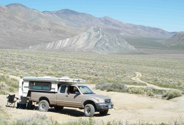
If you do get near The Striped Butte, it makes an interesting short hike. There is a "road" that approaches the Butte from the south and from its end in the sagebrush you can make your way to a ridge and then to the top. The route is easy to see from the Stone Cabin.
 
The last time I drove the long dirt road from Eureka Valley to DV, bits of my truck started falling off and I almost shook my teeth out.


Yes, that's the road. We just take it slow. The really awful washboard is the 9.5 miles south to the Eureka Dunes from Big Pine Road.

Sunman, if we get up these canyons we'll give a report.
 
Hi Pin,

I just thought of another good hike in Butte Valley--Manley Peak. Go to Russell's Camp the (last cabin to the north heading toward Mengal Pass) and hike up the notch to the ridge. There isn't a trail but just stay on the ridge all the way up. I think it's 1500 ft or so. Let me know if you make it up the last little friction bit to the tip top.

When you get down, take a solar shower at Russell's and have a beer and BBQ on the spacious patio. Or if it's too cold, build a fire in the stove. Life is good.

I think I posted this photo of Russell's somewhere before but here she is again. The Manley Peak trail starts behind the photographer.

RusCampse.jpg
 
Got the Lady to look over the maps and Google Earth last evening for trip planning. We are tentatively planning on these spots for adventure: Eureka Valley, Monarch Canyon, Hanaupah Canyon, Johnson Canyon, and Butte Valley. We also just saw that Titus Canyon road just opened. We have never driven Titus.
 
Hi All:
Doing some trip planning. Has anyone driven and camped up the Johnson Canyon Road? We've got a hankering to visit Hungry Bill's and additional explorations in the area. Would like to camp close by if possible. Thanks.


Greetings. Have camped at end of Johnson Canyon. Road is very rocky (cobbles). Well worth the trip, the view of telescope peak is amazing. If you come from Beatty or Ryolite (Goldwell Outdoor Museum) Titus canyon is a must. The road is quite easy. Road to Striped Butte is long but not terrible. Warm springs is a nice stop for a soak before you proceed to geologists cabin. There are four cabins in the area, first come first serve. Couldn't climb hill past cabins with camper on, 3 miles to barker ranch. Not many people out here, come prepared! Good luck.
 

Attachments

  • april 11, 2009 178 (2).jpg
    april 11, 2009 178 (2).jpg
    235.2 KB · Views: 133
Couldn't climb hill past cabins with camper on, 3 miles to barker ranch. Not many people out here, come prepared! Good luck.


Good points, brojez.

I've been over Mengel Pass six or eight times in other rigs and never with a camper. Even if I got up the steep, rutted hill past the cabins, I think I'm too wide with my ATC to fit through the next obstruction, the narrow gap with the rolling boulders. I'd trash the camper on the walls.

Somewhere at WTW, a long time ago, I read a report (maybe from kcowyo) of a FWC who came through from the Barker Ranch side. But it was a smaller camper on a smaller truck. Anyway, the western side isn't as steep to the pass and the hill into Butte Valley has to be gotten down, not up.

Nice pic of the Striped Butte in your post, by the way.


Think I've read that here as well Stew (Mengel Pass with a FWC). Wouldn't mind hearing from someone who has done it with camper for assurance. Been wanting to do it via Goler Wash (downhill) for awhile but not convinced it can be done with a stock Tundra/Hawk Combo. Anyone out there who has done it? Wheel base issues? Seems like it might be in league with Steel Pass, doable with a good spotter?
 
Somewhere at WTW, a long time ago, I read a report (maybe from kcowyo) of a FWC who came through from the Barker Ranch side. But it was a smaller camper on a smaller truck...


Could have been me... we took that route on a trip in '06, and I was in my truck & camper.

I was concerned about going up Goler Wash - my first time on that trail in any vehicle, but it wasn't a big deal as I recall. I do remember our leader saying it had been grated to some extent since his previous visit there. He was expecting more steep steps & drop-offs I think.


_MG_4473.jpg


Following Goler Wash we did stop at Barker's Ranch. Creepy place but glad I saw it before it burned down. Mengel Pass after that was a slow going affair... through the rock garden section and another tight turn or two with other vehicles took awhile to get into Butte Valley and the Geologist Cabin.


L_dv06_046.jpg


Man, looking back, that was a good trip! :)
.
 
None for you, you know what you're doing. I'm sure you've seen similar conditions on some lost trail on the penninsula. Go slow, have an extra pair of eyeballs to check the rocks as you're going through them and the tight turns. Have someone watch your undercarriage as you work through it.

One gentlemen with us in a stock newer Tacoma had me watch his truck's belly as he went through but he did great. We had another guy with us in a Landcruiser towing a trailer, he did just fine with it. That said, that was 4 years ago and my memory only remembers the fun stuff!

Found a few pics online of what you can expect from the rock garden section, maybe a city block long -


DSC08716.JPG


DSC08718.JPG


DSC08720.JPG
 
And it's a tad trickier to get up from Butte Valley to Mengel Pass than it is to come down. Double pucker, so to speak.

Great photos, KCoWyo.
 

New posts - WTW

Back
Top Bottom