Best Backcountry Navigation

Nope. I carry a compass matches knife and water every time I step into the woods. I carry it as well with Delorne map books of the state by page.. That said when traveling in the camper deep in the boonies with my wife as copilot I find the level of discord greatly reduced with the tech help..... As my dad would say when I got into an argument with my then girlfriend..... " son ask yourself before speaking... Am I ready to die on this mountain."..... Pretty much saved me many times.


Sent from my iPad using Wander The West
 
I have used Delorme navigation tools with a laptop PC for navigation in the past, it works good. Am currently using GaiaGPS with a IPad, one with a built in GPS and as much memory as I could buy when it was new. I prefer the Gaia GPS. There is an app for apple product and android products now. Lots of different map types and sources available, can be downloaded and stored on the iPad before a trip to remote places where there are no cell or wi-fi sites. Unique maps are the 1930 USCGS maps and 1910 UCSGS maps, interesting if you are a history buff. Also the old national parks maps include Death Valley outback map, Anza Borrego state park ECT.... You can stack the maps and vary their intensity if desired. Does routes, tracks, waypoints...has folders for your data...latest software update took away all of my Problems with the app. Also use Avenza PDF maps, a great source for small specific maps. It also offers waypoints, tracks...
So many good navigation tools out there these days. I also carry paper maps and a compass, can use them as I did for years in the past. But the abiliyy to put an arrow on your current location and track your progress and plan routes in advance thru areas you have never visited makes exploring a new area much more satisfying to me.
 
p1729418336-5.jpg
 
Are there any good mapping apps for MacBook? Or would it be worth my while to just get an iPad? Can't seem to find any of the mentioned apps in the app store.

jim
 
Jim, look at the android tablets, too. I just got an LG, basically for free with the rebate, and it's much faster than my iPad (gen 2). I will use it mostly for a wifi router, but I'm impressed.
 
We still use a Nexus 7 and our android phones with BC Nav and Delorme apps.
I've also dabbled with Track Me. All these devices have GPS and will track.
The bigger issue is which platform will allow for on device storage when traveling outside coverage.

BC Nav offers USGS 15' maps, which can quickly fill up storage. Delorme Explore offers full statewide downloads which are small enough to download to your phone. In either case, you must download maps before leaving WIFI/3G/4G. The Delorme files are small enough I have several states downloaded on my Samsung Note2, which takes one more item off my To Do list before heading out of town.
 
Hi all!

After doing some searching and reading through this thread... what specific compass do you have?
My (step) brother recommends this military compass, but it's pricey ... what recommendations have you?

thanks!
 
hoyden said:
Hi all!

After doing some searching and reading through this thread... what specific compass do you have?
My (step) brother recommends this military compass, but it's pricey ... what recommendations have you?

thanks!
You can get a very good Silva, Brunton or Suunto for $40-$50.

I use an older Suunto MC 1.

Here's the new version, the MC 2

Suunto_MC-2_360_IN_D_NH.png
 
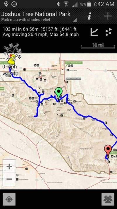
I have a Tissot Ttouch watch that has a compass, altimeter, barometer, thermometer, stopwatch etc.but I usually use my android and maprika which you can download maps before you go to an area that has no service. Here's an example of a recent trip to Joshua Tree

Sent from my SCH-I535 using Wander The West mobile app
 

Attachments

  • 1464619432043.jpg
    1464619432043.jpg
    85.2 KB · Views: 89
Nice to talk about compass's and maps again! Hey, in the old days before GPS (really-almost in the dark ages), I spent most of my time working, inventorying, mapping and getting sometimes lost (for a moment or two :cautious: ) in the back country. I always had my trusty Silva/brunton hand held compass and a topog map, but those were different times because we were trained to use them-had nothing else, ---and the topography. our common sense and the sun to get to work, do our job, get home an have that end of day beer. Even in today's fast paced world, people still need to remember that while all these neat new gadgets make life out in the outback simpler (not that I don't have and gladly use them), what happens when the battery goes out or you forget to down load the right app? You had better know how to do it t old way-------but again, it sure is nice when they work, saves time, worry and gives you more beer drinking time! Just an' old camper/WTWer flashing back :D !

Smoke
 
Back
Top Bottom