Keep an eye out missing couple 395 Dyer area

CALIcamperdad

Senior Member
Joined
Sep 10, 2014
Messages
237
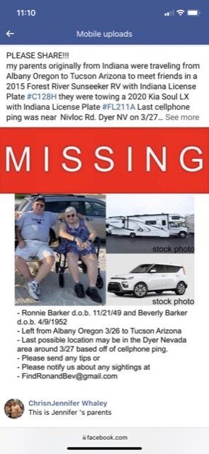
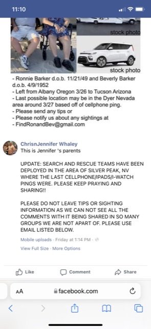
Sun seeker Motor home 30ish feet towing a white kia Soul

License plate on the RV Indiana C128H
White Kia plate FL211A

Missing since March 27th last cell phone contacts was in Dyer NV region. Family member (not me just relaying info from another group) says they are RV park and campground types less so on boon docking. Air search and rescue is reportedly involved at this point.

I don’t see a way to post a picture of the post but will post one if I can sort that out.
 
Ah full version!
 

Attachments

  • C76FED26-2AF4-4CB8-B0DD-AABB474F6D9B.jpg
    C76FED26-2AF4-4CB8-B0DD-AABB474F6D9B.jpg
    70.9 KB · Views: 150
  • 0D377881-795F-434A-A422-2A5DFFDFF434.jpg
    0D377881-795F-434A-A422-2A5DFFDFF434.jpg
    63.2 KB · Views: 133
We were in the Dyer, Nevada area a couple of days prior to the date they were reported missing. Only one RV park in Fish Lake Valley. Other place they may have stopped is Fish Lake Valley Hot Springs, easy to get to with large parking area suitable for large rigs like theirs. I expect both of these were quickly checked off the list. Esmeralda County, Nevada is one of the least populated in the state with few paved county roads.

Please post any additional information that comes up and we hope for a happy outcome. A rig like theirs should be easy to spot.
 
ski3pin said:
We were in the Dyer, Nevada area a couple of days prior to the date they were reported missing. Only one RV park in Fish Lake Valley. Other place they may have stopped is Fish Lake Valley Hot Springs, easy to get to with large parking area suitable for large rigs like theirs. I expect both of these were quickly checked off the list. Esmeralda County, Nevada is one of the least populated in the state with few paved county roads.

Please post any additional information that comes up and we hope for a happy outcome. A rig like theirs should be easy to spot.
I haven’t seen any other news yet. The original post was by a family member on East Bay camping family’s FB group. It sounded like her parents had called one of the parks that day but never checked in. Phones last ping was Dyer area.
 
A little searching -

Missing Indiana Couple Was Headed to Tucson

Search Continues For Indianapolis Couple Missing In Nevada

Authorities Search For Indianapolis Couple Missing In The Nevada Desert

From the information in the above articles, I don't believe they drove over into Dyer/Fish Lake Valley area. One story says a cell phone ping at Coaldale - junction 6 and 95. The same tower, I expect serves both areas. They must be just off of highway 95, the obvious route south. After filling up with gas along 50 at Stagecoach, their next gas stop would have been Tonopah at 200 miles.

There's been a large motorhome stuck up to the axles in gumbo just east of Fallon for over a week now. We thought of that when we heard of this incident. It is not them as the couple was seen much further south in Luning.

This one is a puzzle.
 
"Family members tell 13News Ronnie and Beverly Barker were found Tuesday evening on a mountain west of Silver Peak, about 3 1/2 hours northwest of Las Vegas."

Sounds like they were in the Fish Lake Valley Hot Springs area. That is in the area west of Silver Peak. Two roads lead over the Silver Peak Range back to the east, if they were trying that exit with their SUV. Emigrant Road goes to Coalville (junction 6 and 95) and Coyote Pass Road goes directly east to the town of Silver Peak and the Lithium Mine. Both of these are dirt but fine for a SUV. Paved state highway runs south down Fish Lake Valley to the general store, RV Park, gas station at Dyer. More details?

It is a puzzle.
 
I see there are several GPS coordinates in the comments under the first photo in the section of the article called 'The Search' (click on the 'See more' link under that photo to see them)

One is the location where the RV was found....

"UPDATE 11:56pm EDT 4/5/22
I want to share the precise location of where the RV was located. We still do not know exactly where Ron and Bev were found, or where the car was. Even after all this, I'm still waiting on another final call that could give us some details. So many of you all tried so desperate to find that RV in the Nevada desert... so here is where it was hiding from us. 37.757753, -117.809568 If you copy and paste that into Google Maps you'll see the precise location."

There's another set of coordinates in the next update (at 01:57 am on the 6th). These coordinates appear to be part of a text message from the couple showing their GPS position and the word 'Help'. Unfortunately, that message didn't reach the recipients until after the couple had been found.

"One piece of info... late tonight a single text message was received to Ronnie and Bev's daughters. That text message was trying to send out and I can only assume that as Bev was airlifted to the hospital, or perhaps their belongings were brought down the mountain that message finally came through..... but now we know it arrived too late. No Sheriff Elgan, you did not look everywhere.
37.75325, -117.82469 Help"

There's also an update to the article this evening and I see the car was found about two miles from the RV.
 
Thanks Old Crow for sleuthing out this information. Why on earth did they start traveling down dirt roads with the large RV towing a SUV. Why on earth did they turn off wide graded dirt roads onto smaller and then smaller dirt roads? And then unhook the SUV and not retrace their route in? It appears they were panicked and not making good decisions. There's more to this story. One thing to learn is what navigation program/system were they using, if any?

I suspect they visited Fish Valley Hot Springs and for some reason decided to take the Coyote Pass Road over to the town of Silver Peak and on to highway 95 south of Tonopah. Mileage wise, that would look like the shortest route. A GPS navigation program may suggest it. I suspect, as the grade steepened, they decided to try and find a place to turn that large rig around.

This is all speculation on my part being familiar with the area.

Again, thanks Old Crow.
 
There's an update in the article this morning. Scroll down to "Beverly's Story" (or click the link to it at the top of the page).

"Our hearts are full" article from WTHR13 Indianapolis

Also, Travis made additional entries in his blog-style account of the event (under the first photo in 'The Search') and those include additional details.

A short excerpt from Travis's very long 8:02PM entry last night (4/6/22)

"Beverly stated that the GPS was to blame for getting them into the pickle they found themselves in. The "highway" switch was not turned on in the GPS settings so I suppose it found the shortest route to their destination and that's the way they went. I'm unclear of where they were heading on that Sunday evening, that's a detail I missed when talking with her. In any event they started down the road, following directions. There never was a fear that they were doing anything wrong. Bev recalls they they saw other cars, I believe she even mentioned another motorhome was seen. The directions had them making turns and they knew they were going up a mountain but I don't think they ever had a fear that they were doing anything wrong. Bev said that the RV was doing just fine on the road other than the fact that they had to slow down because the trailer dolly that was bouncing around if they went too fast. Eventually the motorhome became stuck in the gravel and sand that was their roadbed. In my mind I pictured them stuck in the mud, but I think it was more of the sand.
They were going nowhere that Sunday night so they figured that they would just sleep in the RV and just hop in the Kia Soul in the morning and just continue up and over the mountain and get help to free their RV. Without thinking about it, they just got in the car the next morning (Monday) and drove away from the RV. Thought wasn't given to getting some water or blankets... They were ok, they just needed to go get some help to get the RV. Bev said they continued and came across numerous intersections and they took a wrong turn and eventually found themselves stuck again."

See the entry for much more info than provided in the main article.
.


.
 
Their actions are unfortunately understandable. Sad to see someone rely on gps like that but it keeps happening. Too bad a gps can't question the user. Are you sure wish to take a secondary route?
 
Very sad end to an easy to understand error. What is really tragic is that a satellite communicator like an InReach, Zoleo, etc would have prevented a great deal of this - not getting lost or stuck but it would have enabled family to get an accurate location for the couple and allowed the couple to request emergency help or at least, have a family member contact someone locally to assist them.

Yes, it not a cheap solution and seems redundant given the reach of cell phones, but unless you never spend time anywhere but on major highways and in cities, it’s still far too easy to find areas with poor or no coverage.

I would not leave home without ours!


PS - I’m not criticizing or judging this particular couple! There’s is NO way I could. I don’t know them or any really about their circumstances. This is not meant as Monday morning quarterbacking this tragic loss but we should also not miss out the opportunity for this to be a teachable moment for the rest of us …
 
I'll second the InReach. I've carried one for several years now- originally when I was riding a dual sport all over the NC mountains- which have many areas with zero cell coverage. It dawned on me at some point that I could go down an embankment, and be invisible to passersby.
Then later when my grandson and I went on several summer camping trips in the west- we provided the map link to relatives who basically knew where we were every 5 seconds over trips of up to 10K miles.

re bad cell coverage- I really wish the huge amount of money spent on 5G would have been spent on improving coverage. Super high speed matters not to me when I have nothing, sometimes for many miles.
 
In a few places they've located cell towers on mountain tops. Get amazing range.

In hindsight if they'd stayed with the motor home they'd have probably been fine. However, with another vehicle there is a pretty good chance I'd have done the same thing.
 
We just returned from that area. On Sunday we passed just south of there, after coming out of the Monarch Mine area in Death Valley heading to the ancient trees area near Big Pine. Very sad story. Tragic ending. I hope we never forget to triple verify our routes with GPS, Digital Avenza maps and paper maps. We -- so far -- have never lost track of where we are. But events can conspire -- so it is best not to get cocky. Bad things happen to good people. Very regrettable.
 
Extremely sad to learn of this. Looks like the intersection of "Death by GPS" and the "Laws of unintended consequences" once again. Sincere condolences to the survivor and her family.

Reminds me we need to acquire a satellite device before heading out later this year. The couple involved aren't too much older than we are. We have no notions of getting too remote, but there's always that day when we think "Wonder where THAT road goes?". Paper maps usually tell us, but no map is 100% accurate. My wife will tell you "he's driven down decreasing traffic roads before", and I have done exactly that.

Foy
 
Quote from an article above -

"According to KVVU, both are diabetic and Beverly is in a wheelchair."

Diabetes and dealing with anxiety, stress, and unexpected physical exertion can lead to a downward spiral and impaired judgement.

This is a tragic story all the way around. Esmeralda and Mineral counties in Nevada are two of the least populated and have the smallest Sheriff's departments. All the authorities and volunteers did their best with this sad incident.
 
Definitely a sad ending to an otherwise avoidable situation. I do not intend to judge this couple as I am sure this is a failing on my part, but I do not understand their actions at all. I never understood my parents who were super cautious with their motor home and tow vehicle, refusing to go anywhere but developed campgrounds, mostly driving interstates, and reluctant to use even paved state and county roads for fear of a flat tire or other breakdown with no room to safely pull over. This situation was the complete opposite, yet equally mystifying to me. I know it happens regularly, but I can't get my mind wrapped around the idea of trusting GPS based Navigation Programs for directions and following them blindly down unfamiliar, unimproved roads, especially in a large motor home plus a towed vehicle.
 
In trying to understand where the Barkers were, I plotted the GPS positions on Google Maps, GaiaGPS, Garmin Explore, Maps.me, and Mapquest. I tried so many because I couldn't find my way around for lack of road names/numbers and place names in any of them. It's a remote area!

Google Maps was pretty much just a blank until I went to satellite view. And then there were TOO many roads. Following them by zooming out and in and trying to track them to a hard road got tedious quickly.

Caltopo seems to do a little better. The blue dot is the position where the RV was found. The red dot is the position of the text message. Presumably that one was sent from the car after they got stuck the second time.

The intersection of multiple black lines on the far right is the town of Silver Peak.

(Click to enlarge)

CalTopoMapWbarkerGPSpositions485KB.jpg
 

Latest posts

Back
Top Bottom