The peach trees are blossoming. Bees are about. Ants are back. Deer are moving back up. The tractor and snowblower have been powerwashed. Summer tires are back on Julie's Subaru. The awning is installed over the deck. The robins are loud. It is spring.
You are using an out of date browser. It may not display this or other websites correctly.
You should upgrade or use an alternative browser.
You should upgrade or use an alternative browser.
Spring thing
- Thread starter MarkBC
- Start date
OP
OP
Yup, here in Bend, too...with maybe a couple of summer-like days thrown in -- just as a tease.ski3pin said:...It is spring.

Nice Spring day in Barcelona.A few high clouds and sun about 70ish.
Good day for being a lounge lizard.
Frank
Good day for being a lounge lizard.
Frank
rubberlegs
back country campers
Hey ski3pins, does Julie use a tool like this? I saw a similar tool pop up while surfing the web today.
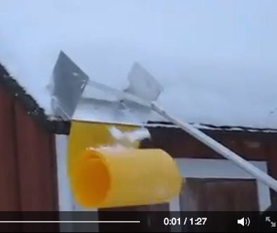
Yes!rubberlegs said:Hey ski3pins, does Julie use a tool like this? I saw a similar tool pop up while surfing the web today.
craig333
Riley's Human
Kind of takes away the thrill of sliding off the roof though
rubberlegs said:Hey ski3pins, does Julie use a tool like this? I saw a similar tool pop up while surfing the web today.
It sure does, Craig! The roof avalanche tool is too heavy for Julie to use for long periods. We got her a light weight aluminum roof rake that is easy for her to handle. She takes the roof snow off a foot or so above the gutters.craig333 said:Kind of takes away the thrill of sliding off the roof though
OP
OP
I opened windows and doors of my house today to let spring air flow through, the first time this year that I felt it was warm enough do do that.
I think today is the warmest day we've had: about 75.
I think today is the warmest day we've had: about 75.
craig333
Riley's Human
Couple more 90 degree days coming before it cools off. I'm wondering if we'll get some grass fires before it does. I've already contacted the city trying to get them to water the dog park.They don't mind watering the medians, soccer fields and the skate park but for some reason the dog park doesn't get the same consideration.
pvstoy
Senior Member
Driving south today out of Phoenix AZ toward Tucson the dash was showing 102 degrees. I feel like a ice cube melted into a puddle then evaporated. Too hot too soon for me!
craig333
Riley's Human
I know, I felt like I was melting today working on the truck. Come august it'll seem like a cool evenging.
OP
OP
I'm wearing shorts today -- the first time in Bend this year.

Yesterday it was also warm enough for shorts... but I guess I wasn't psychologically ready yet.
Update: In another mark of the seasons today, I reversed the direction that my living room ceiling fan rotates, so that now it directs air down instead of pulling it up.
Yesterday it was also warm enough for shorts... but I guess I wasn't psychologically ready yet.
Update: In another mark of the seasons today, I reversed the direction that my living room ceiling fan rotates, so that now it directs air down instead of pulling it up.
Mr. BC, we've been wearing shorts for around three days. That changed this morning. Looks like interesting weather ahead the next couple of weeks -
Special Weather Statement
Special Weather Statement
Code:
Special Weather Statement
National Weather Service RENO NV
213 PM PDT Sun Apr 30 2023

CAZ070>073-NVZ001>005-012200-
Surprise Valley California-Lassen-Eastern Plumas-
Eastern Sierra Counties-Greater Lake Tahoe Area-Mono County-
Mineral and Southern Lyon Counties-Greater Reno-Carson City-
Minden Area-Western Nevada Basin and Range including Pyramid Lake-
Northern Washoe County-
Including the cities of Cedarville, Eagleville, Fort Bidwell,
Portola, Susanville, Westwood, Sierraville, Loyalton,
South Lake Tahoe, Tahoe City, Truckee, Markleeville, Bridgeport,
Coleville, Lee Vining, Mammoth Lakes, Hawthorne, Yerington,
Smith Valley, Mina, Schurz, Stateline, Glenbrook,
Incline Village, Sparks, Verdi, Gardnerville, Virginia City,
Fernley, Fallon, Lovelock, Silver Springs, Nixon, Imlay, Empire,
and Gerlach
213 PM PDT Sun Apr 30 2023


...Cooler, Unsettled Weather this Week...

* A slow moving low pressure system will provide daily chances for
  a mix of rain, snow, and pellet showers this week with rain-snow
  lines lowering to 5500-7000 feet by Tuesday morning. A few
  thunderstorms will also be possible each day (20-30% chance).

* Be prepared for snow showers in the Sierra. While warm road
  temperatures and the early May sun angle may limit accumulations
  on paved surfaces, bursts of heavy snow and/or snow occurring
  during the overnight hours could bring travel impacts to
  mountain passes.

* Expect gusty southerly winds to develop through mid-week with
  the strongest winds targeting portions of Churchill, Mineral,
  Lyon, and Mono Counites with potential crosswind travel impacts
  to US-395 and US-95.

* Temperatures will cool to season averages on Monday before
  dipping 5 to 10 degrees below early May normals through much of
  the upcoming week.

* Additional low pressure systems may track across the region by
  next weekend which could yield continued cool and breezy
  conditions. This may yield more rain and snow showers with snow
  levels remaining around 6000 to 8000 feet.
OP
OP
A similar change up here, Mr. 3pin. A variable couple of weeks ahead, but mostly at or below seasonal temperatures -- with some "weather" at times.ski3pin said:Mr. BC, we've been wearing shorts for around three days. That changed this morning. Looks like interesting weather ahead the next couple of weeks -...

I have my windows closed, furnace running and limbs covered this morning.
(but I don't plan to reset the ceiling fan to winter direction)
rubberlegs
back country campers
Up here in the Pacific NorthWet, we had 75F temps two days ago! But now it's below normal again. Well, summer usually arrives some time after July 5th, and a more glorious summer can't be had.
Yup, the spring thing continues............... we've had snow flakes and hail. The few days of warm temps and clear skies was only a tease.
Special Weather Statement
Special Weather Statement
Code:
Special Weather Statement
National Weather Service RENO NV
237 AM PDT Thu May 4 2023

CAZ070>073-NVZ001>005-050000-
Surprise Valley California-Lassen-Eastern Plumas-
Eastern Sierra Counties-Greater Lake Tahoe Area-Mono County-
Mineral and Southern Lyon Counties-Greater Reno-Carson City-
Minden Area-Western Nevada Basin and Range including Pyramid Lake-
Northern Washoe County-
Including the cities of Cedarville, Eagleville, Fort Bidwell,
Portola, Susanville, Westwood, Sierraville, Loyalton,
South Lake Tahoe, Tahoe City, Truckee, Markleeville, Bridgeport,
Coleville, Lee Vining, Mammoth Lakes, Hawthorne, Yerington,
Smith Valley, Mina, Schurz, Stateline, Glenbrook,
Incline Village, Sparks, Verdi, Gardnerville, Virginia City,
Fernley, Fallon, Lovelock, Silver Springs, Nixon, Imlay, Empire,
and Gerlach
237 AM PDT Thu May 4 2023

...Additional Showers and Thunderstorms Today into the Weekend...

* Scattered rain/snow/pellet showers will once again develop
  today, with a 15-30% chance for a thunderstorm at any given
  location. Rain-snow lines will hover near 6000-7000 feet today,
  falling overnight, where heavier showers could bring snow as low
  as 4500-5500 feet at times.

* Tonight and into Friday, there is a strong signal for the
  heavier showers to focus across north central Nevada, especially
  for Pershing County north of Lovelock. Elsewhere, shower
  activity will be more isolated in nature.

* Yet another round of rain and snow showers arrives Saturday with
  the main focus in the Sierra and northeast California.

* Roadway snow accumulation tends to be difficult this late into
  the season, but is still possible in heavier bands of snow and
  during the overnight hours. If you have travel plans through
  the Sierra, check with CalTrans and/or NDOT for the latest on
  road conditions.

* Breezy southwest to west afternoon winds are expected each day
  today through the weekend. The greater concern is stronger winds
  from any thunderstorms that may develop, particularly across the
  west-central Nevada Basin and Range today.

* High temperatures will remain 5-15 degrees below normal through
  the weekend, but at this point low temperatures in lower
  elevation valleys should remain above freezing. The one time
  frame to potentially watch is Saturday night into Sunday morning
  when typically colder valleys could fall near the freezing mark,
  with a 10% chance of dipping below freezing. Hard freezes are
anticipated for all mountain valleys.craig333
Riley's Human
.05 so far. I don't think I'll get out the rain boots quite yet.
This storm supersized us here on the coast.
We had over 1".Then yucky weather yesterday.
Frank
We had over 1".Then yucky weather yesterday.
Frank
Woke up to a nice brisk 35° this morning. Yesterday brought nearly an inch of needed rain.
Similar threads - WTW
- kmehr
- Trucks, Truck Accessories & Mods
- Replies: 1
- Views: 578
New posts - WTW
-
-

-
-

-
 Trip 2001 - Exploring Northern Nevada, Southwestern Idaho
- Latest: Sagebrush Reconnoiterer
-

-

-
-