Two Weeks in the Great Basin

OTG Ben

Member
Joined
Oct 9, 2024
Messages
13
Location
Northern California
A week ago today, we started our adventure on the Great Basin Heritage Trail that would take us across much of northern and central Nevada and even into Utah. This is a day by day update of that trip.

Day 1: Virginia City to Stillwater Wildlife Refugre
Mileage: 142


Starting on October 11, I met up with a small group of folks in Virginia City to head out on the 2,000+ mile Great Basin Heritage Trail over the course of 14 days. Rolling into Virginia City at 8:30am, the rumble of loud trucks could be heard around town. Driving through the main strip, a large inflatable archway denoted the official start of the race. Taking a quick tour of town, I met up with our small group of folks.

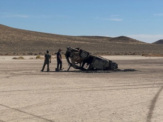
In order to make up a bit of town, we opted to skip the normal route and instead took the rather trail over the pass that goes by the old Como mining camp. This section of trail was incredbily rocky and rather slow going. Finally making it past the slow going sections, we hit a series of BLM and county dirt roads, regularly cruising along at 40-50mph. Along the way, we stopped at the Mad Max playa (we deemed this an appropriate name given the burnt out, abandoned vehicles), and another stop at an old Pony Express station with the corral still in place, and remnants of the old water tank and possibly living quarters.

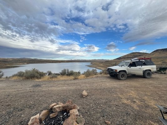
Finally making good time, we set our sites for the Stillwater Wildlife Refuge outside of Fallon. Late in the afternoon we finally made it to the Wildlife Refuge. Running short on daylight, we found a beautiful spot upslope of the regure, with inredible views of the many lakes an playas that dotted the valley. The sunset camp was the best I've seen in a long time!

index.php (16).jpg

Gold Rush truck race would kick off the following day.

index.php (17).jpg


index.php (18).jpg


index.php (19).jpg


index.php (21).jpg


index.php (22).jpg


index.php (23).jpg


index.php (24).jpg


index.php (25).jpg
 

Attachments

  • index.php (19).jpg
    index.php (19).jpg
    191.4 KB · Views: 15
Day 2: Stillwater Wildlife Refuge to Willow Creek Reservoir

As the sun rose over the massive basin, we could see what we thought was a massive lake, was actually a playa stretching several miles across. We hit the road at 9a sharp headed northward towards the Jarbidge Mountains, which we'd hopefully reach by day 3. Our first big stop of the day would be at the old Midas ghost town, which isn't much of a ghost town afterall. While there are many old buildings, Midas still has 11 residents. Pulling into the old mining camp, we were surprised to see a dozen or so people gathered outside the Bighorn saloon. We parked and made our way over. Turns out there were so many people in "town" for a celebration of life. We had a libation, and chatted with one of the locals Paige who filled us in on the goings on in town. The population would soon be to 9, as two of the residents head down to Arizona for the winter.

We said our good byes and continued northward once again. The planned itinerary would put us somewhere in the vicinity of Willow Creek reservoir. The roads were in good condition and we were blazing along. By the time we made it to Willow Creek, the sun was just above the horizon. We found a nice spot overlooking the dam and lake and settled into camp. We were once again treated to another sunset for the ages!

index.php (26).jpg

Rolando treating the group to tamales for breakfast.

index.php (27).jpg

We made good time on the way to Midas!

index.php (28).jpg


index.php (29).jpg

Having a quick libation at the Bighorn saloon. Be sure to ask for Paige if you drop in.

index.php (30).jpg


index.php (31).jpg

On the way to Willow Creek Reservoir.

index.php (34).jpg

Camp overlooking reservoir.

index.php (33).jpg


index.php (35).jpg

Another epic sunset.
 

Attachments

  • index.php (32).jpg
    index.php (32).jpg
    189.4 KB · Views: 15
I have friends who lived in Midas, right across from the Saloon for several years. They moved to Central Alaska when the mining company mothballed the mine and he went to work for one of the company's mines up there. He was good friends with Paige.
 
I have friends who lived in Midas, right across from the Saloon for several years. They moved to Central Alaska when the mining company mothballed the mine and he went to work for one of the company's mines up there. He was good friends with Paige.


Wow! Small world. Paige is definitely a good dude, and was pretty amazed at the expedtion we had embarded on. The Saloon is damn proper given the size of Midas (11 residents), and a must see/drop in for anyone passing through.
 
Day 3: Willow Creek Reservoir to the Bruneau River (Jarbidge Mountains)
I'd been waiting for this day for quite some time. Why? Well, Jarbidge and the Jarbidge Mountains have been on my to do list for quite some time. I also knew that the Jarbidge Mountains would provide quite a change in scenery from the sea of sagebrush that we'd been travelling through for the last several hundred miles. The reason we chose to run the route in reverse starting with segment 3 was due to favorable weather forecast that showed mild temperatures and no precipitation in northern Nevada. So off to Jarbidge we headed!

Our first big stop of the day was at Tuscarora ghost town. Tuscarora was founded after a local Shoshone had shown a settler a gold nugget in the late 1860s, and by 1870 Tuscarora was an official town. Like Midas, Tuscarora isn't much of a ghost town as several residents still live there, but there's nothing like the Bighorn Saloon like you'll find in Midas. Rolling through on a Sunday in the off season, no one was out and about. We kicked off the tour of Tuscarosa by making a stop at the old graveyard. We found headstones from the19th century, and even one from 2024!

We wandered throught town and up the mountain to an old brick tower. Apparently, this was the chimney of the Indepedence Mill towers that overlooks the main part of town. After spending about an hour in the cemetery and town, we decied to head north towards the Jarbidge Mountains.

index.php (36).jpg

Like the Australian outback, the American outback is filled with lots and lots of dust!

index.php (37).jpg


index.php (38).jpg

I wonder, was Adele born in Tuscarora? 42 years young, RIP Adele!

index.php (39).jpg

This impressive chimney overlooks the town of Tuscarora.

index.php (40).jpg

Blazing a trail through the sea of sagebrush. Are we in Jarbidge yet?

index.php (41).jpg

Making our way through the foothills of the Jarbidge Mountains.

index.php (42).jpg

Camp along the Bruneau river. It would get damn cold in this canyon!

index.php (43).jpg

Pete playing around on his HAM radio setup.

index.php (44).jpg
 
Our first big stop of the day would be at the old Midas ghost town, which isn't much of a ghost town afterall. While there are many old buildings, Midas still has 11 residents.
Midas used to have its original schoolhouse, located a block off the main street. It was restored by town residents with financial aid from the mining company. My first visit to Midas was in 2001 and a couple of friends and I were allowed to camp in the school yard in our separate rigs. In the spring of 2008 my wife and I visited town and found the school had burned down, doing so in 2007. Townsfolk are mum about the cause.
 

Attachments

  • t2001_005.jpg
    t2001_005.jpg
    55.6 KB · Views: 12
  • 2008-05-21a.jpg
    2008-05-21a.jpg
    200.1 KB · Views: 12
Day 3: Willow Creek Reservoir to the Bruneau River (Jarbidge Mountains)
I'd been waiting for this day for quite some time. Why? Well, Jarbidge and the Jarbidge Mountains have been on my to do list for quite some time. I also knew that the Jarbidge Mountains would provide quite a change in scenery from the sea of sagebrush that we'd been travelling through for the last several hundred miles. The reason we chose to run the route in reverse starting with segment 3 was due to favorable weather forecast that showed mild temperatures and no precipitation in northern Nevada. So off to Jarbidge we headed!

Our first big stop of the day was at Tuscarora ghost town. Tuscarora was founded after a local Shoshone had shown a settler a gold nugget in the late 1860s, and by 1870 Tuscarora was an official town. Like Midas, Tuscarora isn't much of a ghost town as several residents still live there, but there's nothing like the Bighorn Saloon like you'll find in Midas. Rolling through on a Sunday in the off season, no one was out and about. We kicked off the tour of Tuscarosa by making a stop at the old graveyard. We found headstones from the19th century, and even one from 2024!

We wandered throught town and up the mountain to an old brick tower. Apparently, this was the chimney of the Indepedence Mill towers that overlooks the main part of town. After spending about an hour in the cemetery and town, we decied to head north towards the Jarbidge Mountains.

View attachment 114648
Like the Australian outback, the American outback is filled with lots and lots of dust!

View attachment 114647

View attachment 114646
I wonder, was Adele born in Tuscarora? 42 years young, RIP Adele!

View attachment 114645
This impressive chimney overlooks the town of Tuscarora.

View attachment 114644
Blazing a trail through the sea of sagebrush. Are we in Jarbidge yet?

View attachment 114643
Making our way through the foothills of the Jarbidge Mountains.

View attachment 114642
Camp along the Bruneau river. It would get damn cold in this canyon!

View attachment 114641
Pete playing around on his HAM radio setup.

View attachment 114640
Looks like Pete has a Cha TDL antenna up about 20 feet or more. Wonder if he had much luck making contacts.
Paul
 
Day 4: Bruneau River through the Jarbidge Mountains and to Slide Creek
We awoke to a thick frost and temps in the high 20s. Shasta's dog bowl had a thick layer of ice. Being nice and comfy in my camper, I had no idea that a good chunk of the night had been in the mid to high 20s. Needless to say, we were a bit slow to get rolling as we waited for the sun to peak over the mountains and shed its warmth into the canyon.

Day 4 would find us climbing higher into the Jarbidge Mountains. But before we could make it to the outpost of Jarbidge, we'd need to traverse the narrow and overgrown shelf rode through the Bruneau River Canyon. I'm sure if I was in my old land cruiser this track would've have been so bad. But for 10+ miles, the road is barely wide enough for my full size, many sections have steep drop offs, and to make matters more frustrating, a good portion of the track is overgrown with all kinds of trees and shrubs. I managed to pick up hundreds of new pinstrips, including a big one across the top of my hood! Now I see why the boys in the southeast use limbrisers!

We finally made it through the canyon and onto the main thoroughfare that passes over Bear Creek Summit. The road up and over the summit is wide and graded, easy enough for a Prius! We zoomed up the mountain taking in the changing colors of the aspen. I had no idea the Jarbidge mountains were filled with so many fall colors. While we managed to catch a fair bit of yellow and oranges, many of the aspens had already lost their leaves. It seems like early October would be the best time to witness fall colors in this corner of northern Nevada. Upon making it to the pass, we took a side road to a nice knoll overlooking some of the higher peaks in the Jarbidge Mountains, and to the north of us stood the barren Snake River plain.

Dropping down from the pass was rather easy, and about 30 minutes later we were pulling into Jarbidge. With only one fuel pump in town, we lined up taking our turns to refuel at just under $7 per gallon-- right about what we expected! The guys went down to the only open establishment in town for ice cream, and others for burgers. The folks in Jarbidge were all rather friendly, and I've gotta say, the mountains are spectacular! Leaving town we drove through an impressive canyon with many hoodoos dotting the landscape. Unfortunately, I didn't capture any photos but I definitely have some video that'll make it's way onto the video route guide ;)

After making our way out of the Canyon, we began climbing higher and higher up a massive hill. We decided to check out Slide Creek Campground and determined it would make a suitable camp for the night. Having the entire campground to ourselves, the coyotes sung their feral lullabies in the distance. We gathered around the fire, wondering if another early winter night would pay us a visit-- we were camping at 8500' after all!

index.php (45).jpg

Most of the trail along the Bruneau River was narrow, overgrown two-track.

index.php (46).jpg

Fall colors in the Jarbidge mountains.

index.php (47).jpg

Somewhere above Bear Creek Pass approaching 9,000 feet.

index.php (48).jpg

Looking out at the Snake River plain. The Jarbidge mountains are effectively the northern boundary of the Basin and Range province around these parts.

index.php (49).jpg

hey say Jarbidge has the most remote post office in the lower 48!

index.php (50).jpg

The famous Red Dog saloon doesn't reopen til November, when the winter crowds begin visiting Jarbidge.

index.php (51).jpg

The folks in Jarbidge aren't big fans of the Federal Government. Google "jarbidge shovel" and you'll get the full story!

index.php (52).jpg

A view of the Jarbidge crest above camp.

index.php (53).jpg

Camp at Slide Creek.
 
There is a Alert Nevada camera on a high point on the road coming off of Bear Creek Summit that runs down into the west side of Jarbidge. Cameras are live and take a photo every half minute or so.


You can look at an image where the camera is currently pointed at, or open full size a panorama and look a 360 degree view as if you were standing there and turning around. On the fixed image you can do a time lapse of various lengths up to 24 hours. The camera location got snow last night and it's bright and sunny there now.

The Alert camera system has cameras on mountaintops all over California, Oregon, Nevada, Washington and Idaho.

 
Interesting TR, thanks for sharing.

Here’s a link to the referred to Jarbidge Shovel, and that’s quite the story. I simply picked the first on the Google search, there’s probable more opinions.

Like many things in life, the politics of extreme rural communities (and many communities for that matter) are often filled with irony. The desire to have the Federal Government move aside, while receiving disproportionate amounts of federal tax dollars per capita. No need to go down this rabbit hole ;)
 
Day 5: Jarbidge Mountains to Bonneville Salt Flats
At 8500', we had expected the same bitter cold that we'd experienced along the Bruneau River-- except it never arrived. Upon waking up to the soft golden light of the rising sun, there was no frost to be found. And best of all, since we weren't tucked into a deep mountain gorge, the sun rose over the high sagebrush hills not long after the expected sunrise according to my Garmen watch. Before making our way towards the Utah border, we drove up the hill to snap some photos of the Jarbidge Crest, the highest peaks of which are well over 10,000 feet.

After leaving the Bruneau River gorge behind, the roads were wide and well manicured, and I expected them to stay that way as we departed camp. Except they didn't. Travel was slow going as we bounced along on a rocky and pock marked filled road. Pete radioed back that he needed to stop to investigate some squeaking. Turns out his Yakima rack was failing. With some quick roadside engineering, we were able to secure the rack with some tiedown straps. The plan was to monitor how the rack was holding up and then figure out what to do if it wasn't. Following behind Pete, I could see the rack hoding, but it was swaying side to side in a way that was certainly putting stress across all four of the support bars. After a dozen or so miles of bouncing along, Pete decided there was no way he'd be able to finish another 8+ days on the trail with the rack in its current condition. Pete planned to hit the hardware store in Wells and engineer a much sturdier fix.

We wished Pete well as he set off down the highway. We followed the same stretch of pavement for a few miles before jumping off onto the dirt once again, and onto the lands of the massively large Winecup Gamble Ranch. The rolling hills sagebrush covered hills were once again in front of us, but this time odd mesas and other geometric shapes topped many of the hills. The three of us kicked up dust while averaging 50+ mph as we ripped across the desert. Soon enough we were on a bumpy county road and closing in on the Utah state line. But before we could cross into Utah, we'd need to drive a short stint on the Interstate that would bring us to the twin cities fo West Wendover/Wendover. After filling up on some much needed fuel, we made a beeline for the salt flats where I launched the drone and took photos of the alien landscape that we were driving on. And then I got the call from Pete, who rolled out onto the Salt Flats a few minutes later!

After our fun on the salt flats, we set off looking for camp. We ended up at a great spot on BLM land overlooking the salt flats, with some impressively craggy cliffs behind us.

index.php (45).jpg

The morning alpenglow at Slide Creek.

AP1GczOwPKgaA9xLbR9ra8XUTVTbUmRh.jpg

600+ miles of mostly dirt covered before heading out on the trail!

index.php (47).jpg

The Jarbidge Crest. Can you spot the Matterhorn?

index.php (48).jpg


index.php (49).jpg

Lots of bumps led to...

index.php (50).jpg

A broken Yakima Rack (do not recommend for overlanding/off roading!). Trailside engineering at its best.

index.php (51).jpg

Will we make it to Utah today?

index.php (52).jpg

Pilot Peak in the background, Utah only a few short miles away!

index.php (53).jpg

Yep, we made it to Utah alright (Bonneville Salt Flats).

index.php (54).jpg

Camp overlooking the salt flats on a warm fall's night.
 
Back
Top Bottom