Winter road trip wandering out west...

Thanks for all the great ideas and advice. I have to get my maps out and check these various routes out. Ideally we'd be on back roads the whole way but I don't know if that is feasible in the schedule. We have a deadline to be in SF and will likely have only 4 days to make the trip out. Once we get past that our schedule opens up for the coast trip. Of course, bad weather anywhere could throw the schedule out the window.
 
We travelled Hwy 299 from the California/Nevada border through Redding, CA to just north of Arcata where it Ts into 101 a few weeks ago. A hairy ride but very scenic. Many tight curves, elevation changes, roadwork, semis, logging trucks, people in fast cars in a hurry and a big boulder in our lane we just missed. I don't think we will drive it again but it was an experience. One of the highlights of our month long trip was camping at a BLM campground along the Pit River with a couple of shallow waterfalls and gorgeous fall color and we had it all to ourselves ($4). It was the only one open as we stopped by a BLM center in Alturas for info.

I agree that driving the Oregon Coast/Redwoods leg will be one of the highlights of your trip. We stayed at Harris Beach State Park campground north of Brookings. It seemed most of the coastal campgrounds were open as we passed through last week. In Newport, there is a highway that will take you into Corvallis over the Coast Range. I am not sure about winter driving on that one as we only drove it several times in September.

Seattle-Tacoma traffic can be a madhouse rush: people trying to drink their Starbux while on a cellphone (illegal but it's a "right" for some folks). The worst part is trying to figure out which lane to stay in. Try going through between 10 am and 11 am and it shouldn't be as bad. Have a great trip and enjoy the family time.

Thanks for the tips. We are getting serious about driving the "loneliest road in America" (US50) across Nevada. Also quite looking forward to the coast road trip. The Nevada leg will be weather dependent on whether we try it or not. Here's hoping for good weather.
 
<snip> We are getting serious about driving the "loneliest road in America" (US50) across Nevada. <snip> The Nevada leg will be weather dependent on whether we try it or not. Here's hoping for good weather.


The Lady will not let us drive Interstate 80. :)
 
The Lady will not let us drive Interstate 80. :)

I'm pretty sure we would both like to meet the Lady. She sounds pretty great. :) And of course, you too for that matter. You both seem to have a great outlook on life. I-80 is definitely not our cup of tea. Unless the weather is forecast to be really bad, we will no doubt take the route less traveled. I did read somewhere that I-80 has the highest priority to be kept open in bad weather of any of the western highways. Any suggestions where to camp along US 50? Not sure of our schedule yet.
 
I'm pretty sure we would both like to meet the Lady. She sounds pretty great. :) And of course, you too for that matter. You both seem to have a great outlook on life. I-80 is definitely not our cup of tea. Unless the weather is forecast to be really bad, we will no doubt take the route less traveled. I did read somewhere that I-80 has the highest priority to be kept open in bad weather of any of the western highways. Any suggestions where to camp along US 50? Not sure of our schedule yet.

:LOL:
There are several year-round CG along the HW, more depends on snow levels and weather more than anything else where you can go, but check with MarkBC on the BLM,NPS or FS winter CG's east of Austin (have a thread going on that right now) , the GBNP for places that are open too! A real good site tool to find camping areas in the eastern Sierras ,GB and Nevada is actually called the "camping Guide to the Eastern Sierras and Nevada" and the USFS "campgrounds on the HTNF" on the FS site-BLM also has a site on it's State Office page that lists CG's!

FYI-spent some times years ago working on that hidden Pit River BLM CG, it was even more primitive before; next time try out the one SE of Fall River Mills out in the middle of the sage, manz, digger pine and deer brush-neat rock formations and underground caverns too. We had an adventure there one time, had some rancher telling chasing hunters off of it (we even had signs saying it was BLM) and saying it was private ground then taking both the deer they killed and their guns.. It just points out again, the need to know where you are at at all times and how important it is to talk to the local land managers before you wonder around in unknown areas and have lot's of maps! One other rule to remember was hammered into us gov't employees was if someone told you to get off "his " land" and you knew it was public land, get off! Go to the nearest gov't office and let them take care of it-I mean we got the above hunters and both their deer and guns back to them, that day but the day that this happened they flagged down a passing fs employee and they called us and we were there as fast as the LE Ranger and me could do it. Maps, Maps, and remember they call it public land for a reason and despite the puns-it's your land and we are there to help you enjoy it--if we can!!:LOL:(at any rate supposed to help you).

Smoke
 
(have a thread going on that right now)

Smoke


Smoke, thanks for the tips. I am watching that other thread for ideas too. -Al
 
I'm pretty sure we would both like to meet the Lady. She sounds pretty great. :) And of course, you too for that matter. You both seem to have a great outlook on life. I-80 is definitely not our cup of tea. Unless the weather is forecast to be really bad, we will no doubt take the route less traveled. I did read somewhere that I-80 has the highest priority to be kept open in bad weather of any of the western highways. Any suggestions where to camp along US 50? Not sure of our schedule yet.


The possibilities are limitless, but as others have said do make sure you are on public land. Roads go off all over. Many do lead to ranches or small enclaves. A couple of easy places to find for overnight from east to west are - Lower Lehman Campground in Great Basin National Park (MarkBC will be the only one there :)). You can spend the night at the rest area on Sacramento Pass. Closer to Ely is the nice campground at Ward Charcoal Ovens (a few miles off the road and you might call to see if it is open). Between Ely and Eureka is Illipah Reservoir Campground (not the most scenic but it'll do). Between Eureka and Austin is the Hickison Petroglyph Site with it's free campground. We like this spot. Just before the Toiyabe Range is the Big Smokey Valley Road. Take that south a very short distance and turn east on the very easy gravel road. Out a few miles is Spencers Hot Springs. These are not our favorite soaking spot but there are lots of places to drive away to camp. To the north you will see a small rise and a road leading that direction. Near the top of Austin Summit is the USFS Bob Scott Campground (I'd call Austin Ranger District to see if it's open). If you are close to Fallon, you can drive out the Grimes Point Archeology Site Road. I believe you can camp at the Hidden Cave Parking area where there's an outhouse (nothing says you can't spend the night). There are other spots further out the road but I'd be sure and do that in the daylight. These are just some starters off the top of my head.
 
Grimes Point Archeology Site Road. I believe you can camp at the Hidden Cave Parking area where there's an outhouse (nothing says you can't spend the night). There are other spots further out the road but I'd be sure and do that in the daylight. These are just some starters off the top of my head.


Here's some more archaeology for those interested in the USA cave arts: http://www.facebook.com/media/set/?set=a.10151252341587439.485568.810507438&type=1
 
ski- thanks for all that information. It helps planning a lot to be able to have some targets when looking at the map. We are trying to estimate driving times under different scenarios to see which are likely stopping points. We will need multiple targets depending on weather conditions. Unfortunately this trip we will have a deadline to be in San Francisco so we won't have a lot of time to explore but it is great to have some recommendations from folks who know the area. No doubt this trip we will whet our appetites for return visits. :)

Gene, not being a facebook person, I wasn't able to look at that link. :(
 
Thanks for the tip. Those do look pretty nice. I suppose if I got some good ones, I might use them around here in the backwoods too.


HaHa- yeah, winter can be brutal here, but with the general warming trend, that is getting less true. I have been ice fishing at -55 below zero (actual, not windchill) but we haven't seen anything remotely close to that for probably 10 years.


Good tip. I checked out the site- looks like a must stop. Got to love the bacon.


Yeah, I've driven that I-80 route 4 times in the past year. You are right- the Wyoming stretch can be tough. That's the only place I saw snow last January, but thankfully it was not much and not a problem. The wind and icy patches were more an issue. The I-90 route is too far north for the way out. We will take that coming home.

Thanks for the tip about the approach to SLC. It is culture shock to all of a sudden hit that downtown stretch after 2 days of open country freeway. Have you got any tips for camping spots around there?


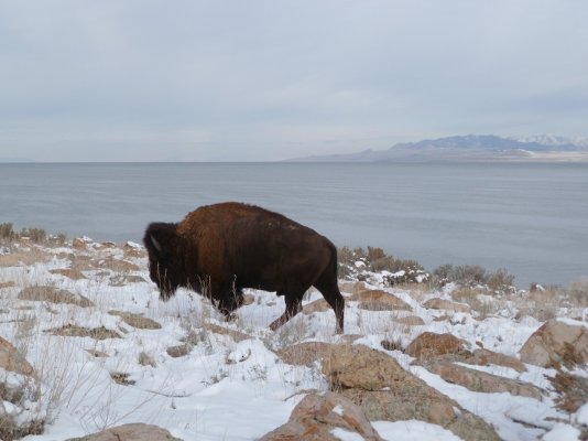
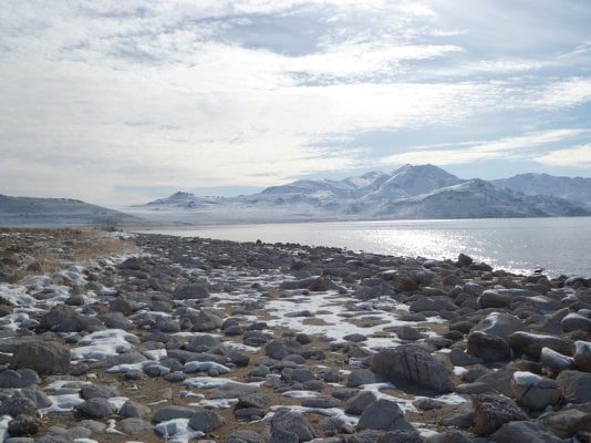
Antelope Island State Park may work for you as it is 30 minutes from the junction of I84 and I15. Open all year but the entrance closes at 5:30 in the winter.

Spent a night and day there last weekend and had the CG to myself. Nice hike around the point and back from the CG about 4 miles round trip. Saw bison, coyote, and deer. Here are a few photos..
 

Attachments

  • buff 1.jpg
    buff 1.jpg
    169.3 KB · Views: 85
  • rocky shore 1.jpg
    rocky shore 1.jpg
    218.2 KB · Views: 101
Antelope Island State Park may work for you as it is 30 minutes from the junction of I84 and I15. Open all year but the entrance closes at 5:30 in the winter.

Spent a night and day there last weekend and had the CG to myself. Nice hike around the point and back from the CG about 4 miles round trip. Saw bison, coyote, and deer. Here are a few photos..


Beautiful pictures!
 
Beautiful pictures!


Thanks-it's a pretty nice place. Especially considering its proximity to 1 million+ people. Looking to the east from high points you can see most of the wasatch front, where all the people are. Turn to the west, nothing but water and range, mostly. If you make the attempt, you can see the Magcorp and Kenecott stacks, though I usually don't try.
 
Antelope Island State Park may work for you as it is 30 minutes from the junction of I84 and I15. Open all year but the entrance closes at 5:30 in the winter.

Spent a night and day there last weekend and had the CG to myself. Nice hike around the point and back from the CG about 4 miles round trip. Saw bison, coyote, and deer. Here are a few photos..


Great info and photos. This would be a good site if we end up taking the I-80 route. Thanks!
 
Well, I got some chains- RUD 4x4. They are not the cheapest but they didn't cost that much more than the cheap cable style and they seem much better. Bought them from this site- http://tirechaindealer.com/ It was the best price/shipping that I found. The service was fast with good communication. I would recommend them. According to the site, the business is owned by a disabled vet. I'm going to try putting them on today to see how it goes. Less than two weeks until we leave. Watching the big storm about to hit the coast- wondering what it might do to the coast road...

Edit- got the chains on but not without some newby difficulties. The instructions and the video on the website make it look easy. Out of the package, the chains were connected together and had to be disconnected. The instructions were not clear on all the steps necessary to get them ready to install. An experienced person would have known but it took me awhile to figure it out. Once I figured that out, things went a little more smoothly. The instructions show the chains sliding around on a smooth tire for positioning. In reality, the chains catch on the deep tread on the backside of the all-terrain tire which makes moving them around and adjusting them difficult. I'm sure with some practice it will be fine. Once I finally got them on, the instructions made complete sense. haha.
 
Well we are off tomorrow early am. Should be on the "loneliest road in America" by Friday. Since we got 15 inches of snow here over the weekend and temps in the single digits, I think whatever we run into weather-wise will be an improvement. Stay tuned for a trip report sometime in January when we get home. :)
 
Hey all, a quick check in from the road. We made it to San Francisco- had a fine time getting here. Camped in Golden Gate Canyon in Colorado (totally by ourselves), Great Basin National Park (only people in the park besides the staff), and Bob Scott USFS campground in Nevada (totally by ourselves- see a common thread here?). We camped at altitudes ranging from 7000 feet to nearly 10,000 feet and had snow in every campground. Temps in the teens at night but stayed warm. Still managed to do our cooking outdoors. Drove the entire length of US 50 through Nevada. Awesome. What a great suggestion that was! Wish we had had a lot more time along the way to explore- I know we missed a lot. Now we are off to see the coasts of California and Oregon. I will post a full blog report in January when we get home. Here are a couple of teaser photos from Great Basin National Park:

gallery_2966_33_196137.jpg


gallery_2966_33_763565.jpg
 

New posts - WTW

Back
Top Bottom