Laguna San Ignacio

My understanding is that Tourist Cards are no longer available at Mexican Consulates in the U.S.


You are correct Jay. It's an easy 10 minute transaction for a FMM at the border (~$23US). Use the declaration lanes to the far right and park as soon as you cross the border.
 
Jay, putting this out there for others on the trip to comment on: I am still trying to figure out a reason why people would rather cross at Tijuana than Mexicali? Mexicali to Laguna Chapala/Mex.#1 via the Sea of Cortez route takes no longer, in fact it takes less time on several trips that I have made the comparison.

Crossing at Tj, you get the insane traffic of TJ to Ensenada with the toll roads, the exceedingly unpassable, slow, smog belching truck traffic that persists all the way to San Quintin which takes hours and hours. You get the all crime ridden/trashed out towns of northern Mex 1.

I just think that those going might consider driving the Sea of Cortez's small towns, San Felipe/Gonzaga route. It takes the same amount of time, some of the very best scenery in Baja (David K, top baja poster on bajanomad.com agrees, the Expedition Portal trip is also going this way: http://www.expeditionportal.com/forum/threads/65137-Baja-The-Gray-Whales-2012 ). That being Mexicali to San Felipe, to Gonzaga Bay (one of Baja's top jewels), Coco's Corner, and then finally reaching Mexico #1 and avoiding the trashed out, crime ridden areas. The route I recommend is legendary as one of Baja's most scenic "must do" road.

Hmm...the Sea of Cortez route, a Baja Jewel vs. northern Mex 1, the armpit of Baja....kinda' no brainer. Another thought, we could all meet at Laguna Chapala and people can make their own choices.

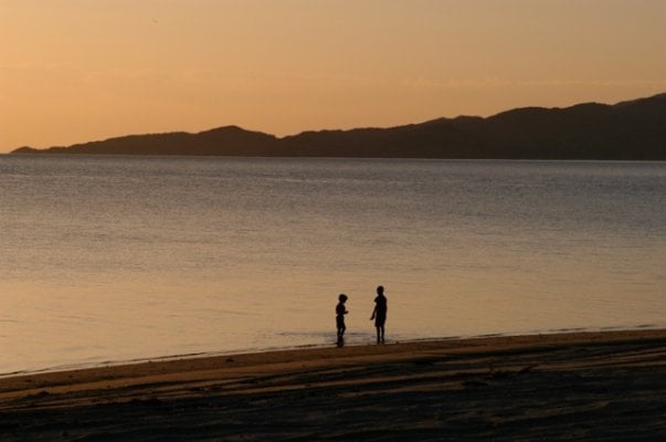
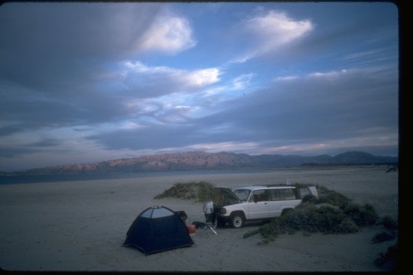
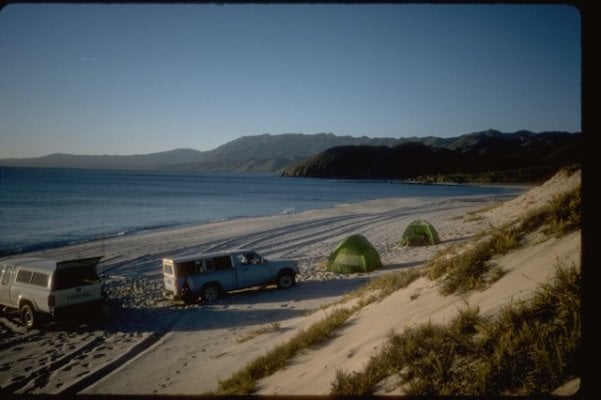
Pics from Sea of Cortez route:
 

Attachments

  • Img0138.jpg
    Img0138.jpg
    56.7 KB · Views: 83
  • Photo 11 of 112.jpg
    Photo 11 of 112.jpg
    50.7 KB · Views: 81
  • Photo 33 of 112.jpg
    Photo 33 of 112.jpg
    72.1 KB · Views: 77
ok, I see why. From Sacramento Mexicali is 60 miles farther. From Ventura its 80 miles father. But...are we in a hurry? I suppose the more adventurous of us can take Sea of Cortez on the way back. Alfonsina's and Gonzaga Bay are a must for me.
 
I agree with Gene that the route through Mexicali down to Gonzaga and then out to Hwy1 is the more scenic way to go by a long shot. Based on the reports I've seen it appears to be a bit safer as well. Although traveling with a group would bring the danger factor way down regardless which route we take. In fact it would also be the shorter route (by a day) for me, Mark from Houston and other non California residents. So here are the distances from Sacramento based on Google Maps .

Sacto to Mexicali = 610 miles
Mexicali to Guerrero = 375 miles
total 985

Sacto to TJ = 520 miles
TJ to Guerrero = 445 miles
total 965

As you can see the difference is only 20 miles. When I lived in California I went both ways dozens of time and preferred the Sea of Cortez route by far over the Pacific Ocean route.

So, we can go one way or the other and meet down the peninsula. Maybe at the Pemex station in Villa Jesus Maria or Guerrero Negro. Please know It is not my intention to be The Leader. I stopped supervising adults (or kids for that matter) when I retired. I'm just acting as a organizer and clearing house for the ideas of those who wish to make this trip. So please give your input on this.
 
Smart move Phil. You always take the path of greater adventure!

Michael Rubin is definitely coming with us so that makes at least three of us jammers. Maybe we can get Jay to bone up on his guitar. Oh yes, maybe Nina can come! I'm bugging here right now, she's in my kitchen.


Mikey Rubin:
 
Well that makes three. Pam and I will be going in through Mexicali as well. Others may wish to go the TJ route but as I said before we can all meet up in Villa Jesus Maria or Guerrero Negro. But those of you wanting an extraordinary coastal road trip, it's hard to beat the 48 miles from Puertecitos to Gonzaga.
 
Counting the cost:

Gas...... $1300
Insurance. 200
Passports. 250

OK, we have to come up with ~$2000 in order to be able to do this...
 
Here are some insurance quotes for my truck. This is liability only but a search of the site has full coverage as well. The several of the companies represented here have very good ratings as does the agent.
http://mexicaninsurancestore.com/quote3.asp


There isn't much I can do for you on gas and diesel. Although there is this.
http://gasbuddy.com/

As far as a passport you really need to apply (6 weeks before trip) now. It isn't a bad thing to have even if you don't head down there with us.
 
As far as a passport you really need to apply (6 weeks before trip) now. It isn't a bad thing to have even if you don't head down there with us.

Yewbetcha. Fixin' to this week.
 
Mark,
In these times I know how tough it is to come up with the dough but I'd love it if you guys could go. My reason is selfish of course I'd like to meet y'all in person.
 
Counting the cost:

Gas...... $1300
Insurance. 200
Passports. 250

OK, we have to come up with ~$2000 in order to be able to do this...


How about Big Bend :D $350 in gas, no passports or insurance! I'll be there Monday.
 
Here is a decent video about San Ignacio Lagoon Gray Whales and Pachico who lives in the first camp you arrive at.

http://www.pachicosecotours.com/PachicoNewsVideo.html

You tube is, of course, full of other videos. I've done the Gray Whales many times. Changes you forever.
 
20 years ago we met Pachico. He was the El Presidente del Ejido at that time. He looks the same in the video as he did then. I don't!
 
last week of March / first week of April?

OM it is looking good for these dates on my end, I Will update all on this end to start to get confirmations and amount of travlers

Phin
 
Back
Top Bottom