craig333
Riley's Human
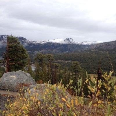
Rain here also, enough to make everything wet, not enough to fill the gutters. Forecast for my trip is looking a little more "interesting".
")
400 AM PST FRI NOV 13 2015

...NEXT FALL WEATHER SYSTEM WILL MOVE THROUGH NORTHERN CALIFORNIA
SATURDAY NIGHT AND SUNDAY...

.IMPACTS...

  *SLICK ROADS DUE TO RAIN AND HIGH ELEVATION SNOW WITH TRAVEL
   DELAYS AND CHAIN CONTROLS IN THE SIERRA POSSIBLE.

  *DEBRIS FLOW POTENTIAL OVER RECENTLY BURNED AREAS.

.FORECAST CONFIDENCE...

  *HIGH FOR RAIN AND SNOW DROPPING TO BELOW PASS LEVELS.

  *LOW FOR POTENTIAL DEBRIS FLOWS UNDER HEAVIER SHOWERS.

.TIMING AND STRENGTH...

  *PRECIPITATION WILL MOVE IN TO THE NORTH STATE DURING THE
   EVENING HOURS SATURDAY THEN SPREAD SOUTHEASTWARD TO THE
   NORTHERN SIERRA BY SUNDAY MORNING. SHOWERS WILL CONTINUE
   THROUGH SUNDAY...ENDING MOST AREAS BY MONDAY MORNING.

  *RAIN AMOUNTS RANGING FROM 0.10-0.50 INCHES IN THE VALLEY AND
   COASTAL MOUNTAINS AND UP TO ABOUT 1 INCH OVER THE SIERRA.

  *SNOW LEVELS DROPPING FROM 6500 TO 7500 FEET SATURDAY NIGHT
   DOWN TO 4500 TO 5500 FEET ON SUNDAY. SNOW LEVEL 3500 TO 4500
   FEET SUNDAY NIGHT AS THE PRECIPITATION TAPERS OFF.

  *SNOW AMOUNTS FROM SATURDAY NIGHT THROUGH SUNDAY NIGHT ABOVE
   5500 FEET ARE FORECAST TO RANGE FROM 4 TO 8 INCHES WITH AS MUCH
   AS A FOOT AT HIGHEST ELEVATIONS.

.WEATHER SUMMARY...
ANOTHER COOL PACIFIC STORM SYSTEM WILL MOVE THROUGH THE AREA
SATURDAY NIGHT INTO SUNDAY. RAINFALL WILL BE POSSIBLE AS EARLY AS
LATE SATURDAY EVENING OVER THE FAR NORTHERN SACRAMENTO VALLEY WITH
RAIN AND SNOW CHANCES REACHING THE NORTHERN SIERRA BY EARLY SUNDAY
MORNING. ALTHOUGH THIS IS NOT EXPECTED TO BE A HEAVY PRECIPITATION
PRODUCING STORM...HEAVIER EMBEDDED RAINFALL COULD PRODUCE DEBRIS
FLOW IF CELLS DEVELOP OVER RECENTLY BURNED AREAS. SNOW LEVELS WILL
DROP QUICKLY WITH THIS SYSTEM AND ARE EXPECTED TO REACH SIERRA
PASS LEVELS BY EARLY SUNDAY MORNING. SNOWFALL OVER THE PASSES
SUNDAY WILL IMPACT MOUNTAIN TRAVELERS. IF TRAVELING THROUGH THE
SIERRA SATURDAY NIGHT THROUGH SUNDAY NIGHT... CARRY TIRE CHAINS
AND BE PREPARED FOR POSSIBLE DELAYS.


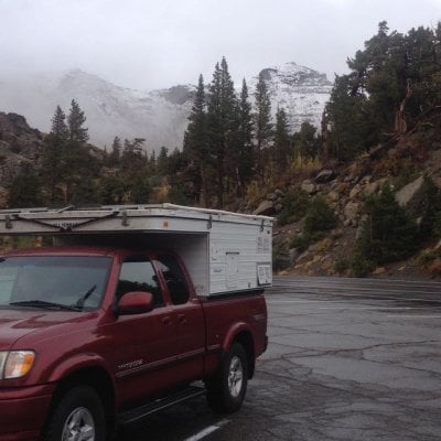
I just got power last night. The mountains are really beautiful but I really could have done with out the 50 mph winds. I am always amazed how beautiful and clear the sky is after the big storms come through.MarkBC said:NOAA: Biggest Storm Since 2014/15 to Hit Oregon This Weekend | 25′ Waves, 60mph Winds 20″ of Snow
Hope so!
Snow = good. And sounds like a fun time to be at the coast.

I should be OK. I'm not driving until Wednesday afternoon, so highways should be plowed and sanded by then. (assuming that the forecast is accurate and the snow stops by Wednesday morning)Wandering Sagebrush said:Mark, carefull. Rain, then freezing weather on this side of the hill.