Meteorological Winter

Winter Storm Watch
Code:
URGENT - WINTER WEATHER MESSAGE
NATIONAL WEATHER SERVICE SACRAMENTO CA
319 PM PST TUE DEC 13 2016

...WINTER WEATHER RETURNS TODAY...

.WINTER WEATHER IS FORECAST TO RETURN TO THE NORTHERN SIERRA
NEVADA AND CASCADE RANGE TODAY INTO WEDNESDAY. ONLY LIGHT AMOUNTS
OF SNOWFALL ACCUMULATION ARE EXPECTED BELOW 7000 FEET, WHILE
HEAVIER SNOWFALL AMOUNTS WILL BE LIMITED TO THE HIGHER ELEVATIONS
OF MT LASSEN.

A SECOND, AND LIKELY STRONGER WINTER STORM HAS THE POTENTIAL TO
BRING MORE SIGNIFICANT TRAVEL IMPACTS TO THE NORTHERN SIERRA AND
CASCADE RANGE THURSDAY AND FRIDAY. A FOOT OR MORE OF SNOWFALL
ACCUMULATION WILL BE POSSIBLE THROUGH THE HIGHER ELEVATION PASSES
ALONG WITH STRONG GUSTY SOUTHWEST WINDS RESULTING IN WHITE-OUT
CONDITIONS AT TIMES.

CAZ068-069-141400-
/O.CON.KSTO.WS.A.0012.161215T2000Z-161217T0200Z/
WESTERN PLUMAS COUNTY/LASSEN PARK-
WEST SLOPE NORTHERN SIERRA NEVADA-
INCLUDING THE CITIES OF CHESTER, QUINCY, AND BLUE CANYON
319 PM PST TUE DEC 13 2016

...WINTER STORM WATCH REMAINS IN EFFECT FROM THURSDAY AFTERNOON
THROUGH FRIDAY AFTERNOON...

* MAIN IMPACTS: SLIPPERY ROADS, LOW VISIBILITY, CHAIN RESTRICTIONS
  AND TRAVEL DELAYS POSSIBLE.

* TIMING...LIGHT SNOW IS EXPECTED INTO TONIGHT. HEAVIER SNOW IS
  POSSIBLE THURSDAY INTO FRIDAY.

* LOCATIONS...INTERSTATE 80 OVER DONNER PASS, HIGHWAY 50 OVER ECHO
  SUMMIT, HIGHWAY 88 OVER CARSON PASS, AND LASSEN VOLCANIC
  NATIONAL PARK.

* SNOW ACCUMULATIONS...1 TO 2 FEET OF SNOW ACCUMULATION POSSIBLE
  OVER THE HIGH SIERRA MOUNTAIN PASSES.

* OTHER...ANYONE PLANNING MOUNTAIN TRAVEL LATER THIS WEEK IS
  ADVISED TO STAY IN TOUCH WITH THE LATEST FORECASTS.

PRECAUTIONARY/PREPAREDNESS ACTIONS...

A WINTER STORM WATCH MEANS THERE IS A POTENTIAL FOR SIGNIFICANT
SNOW ACCUMULATIONS THAT MAY IMPACT TRAVEL. CONTINUE TO MONITOR
THE LATEST FORECASTS.

 
Wandering Sagebrush said:
I just saw the weather forecast... :( I think we are going to get clobbered tomorrow afternoon. Maybe snow into double digits... It's fun in the mountains, notso fun here in the flatlands where all the crazy people live.
Now they're saying around an inch... I'm renaming our weatherman to Lying Leon. Who knows what we will actually get...
 
There's a WINTER STORM WARNING for the eastern 2/3 of Oregon -- from the Cascade Range east to the Idaho border. The Central Oregon part of the Warning:

... WINTER STORM WARNING IN EFFECT FROM 4 AM TO 11 PM PST WEDNESDAY... THE NATIONAL WEATHER SERVICE IN PENDLETON HAS ISSUED A WINTER STORM WARNING FOR HEAVY SNOW... WHICH IS IN EFFECT FROM 4 AM TO 11 PM PST WEDNESDAY. THE WINTER STORM WATCH IS NO LONGER IN EFFECT. *
LOCATIONS... BEND... MADRAS... PRINEVILLE... REDMOND. *
SNOW ACCUMULATIONS... 10 TO 15 INCHES. *
TIMING... SNOW WILL START BY SUNRISE WEDNESDAY AND INCREASE DURING THE DAY. SNOW WILL TAPER OFF WEDNESDAY NIGHT. *
IMPACTS... AREA ROADWAYS WILL BE SNOW COVERED AND SLICK. LESS TRAVELED SIDE ROADS COULD BECOME IMPASSABLE. THE VISIBILITY WILL BE POOR AT TIMES WITH SNOWFALL RATES OF 1 INCH PER HOUR EXPECTED. *
HAZARD ELEVATION... ALL ELEVATIONS. *
WINDS... NORTH 5 TO 10 MPH. *
WEB PAGE: FOR A DETAILED VIEW OF THE HAZARD AREA VISIT HTTP://WWW.WRH.NOAA.GOV/MAP/?WFO=PDT.
PRECAUTIONARY/PREPAREDNESS ACTIONS... A WINTER STORM WARNING FOR HEAVY SNOW MEANS SEVERE WINTER WEATHER CONDITIONS ARE EXPECTED OR OCCURRING. SIGNIFICANT AMOUNTS OF SNOW ARE FORECAST THAT WILL MAKE TRAVEL DANGEROUS. IF YOU MUST TRAVEL... KEEP AN EXTRA FLASHLIGHT... FOOD... AND WATER IN YOUR VEHICLE IN CASE OF AN EMERGENCY. &&

More Information
... SIGNIFICANT SNOW WEDNESDAY THROUGH WEDNESDAY NIGHT... .A STRONG AND VERY WET PACIFIC STORM SYSTEM WILL MOVE INTO THE REGION WEDNESDAY. THE AIR MASS ACROSS THE REGION WILL BE COLD AND SIGNIFICANT SNOW ACCUMULATIONS ARE EXPECTED WEDNESDAY AND WEDNESDAY NIGHT.


3:28pm PST, Tue Dec 13

I think I'll be driving my truck for the next few days, so with that in mind I went out and started it for the first time in 6 weeks -- fired up like a champ! I have a doctor appointment mid-morning tomorrow or I'd just stay home until the snow-induced road-chaos subsides (i.e., when the roads get plowed).
(My little Hyundai does fine in the snow, traction-wise, but it's low to the ground so can't deal with deep snow.)
 
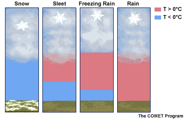
If this GIF file works.... a nice explanation of precipitation.
 

Attachments

  • Precipitation.gif
    Precipitation.gif
    66.2 KB · Views: 69
buckland said:
If this GIF file works.... a nice explanation of precipitation.
Cool!
This points out the not-generally-known fact that even rain usually starts as snow way up there, in the cloud.
(a different "cloud" than where Google & Facebook store info)
 
For just a few inches of snow, the Willamette Valley sure is a mess this morning. It's just below freezing, the streets are snow packed or icy, and I'm thankful this doesn't happen frequently. My guess is things are going to stay this way for three or four days.
 
and here north of you in the land of Starbucks hipsters, its clear and dry and a few degrees warmer ( a little more marine influence on the temps I guess)
 
Wandering Sagebrush said:
Now they're saying around an inch... I'm renaming our weatherman to Lying Leon. Who knows what we will actually get...
Lying Leon, that's funny. I wouldn't want to turn this into a weatherman bashing thread as it deserves one on it own. But as the old saying goes a weatherman has the only job in television you can get wrong everyday and not lose. Much like NOAA should budget for a window that opens in there buildings so they can hold out a hand for accuracy. With all they have, I give them credit for getting it close most of the time. I'm in the midst of SanFrancisco Bay Area , and today's reports from Leon are for a catostrophic afternoon commute. All blamed on wind and rain. Truth is the catostrophic failure will be the 85 % of commuters(my guess) who are texting or talking while traveling at 70 mph, at least snow slows it down. If I would have ordered my ATC 4 months ago, I now would be driving towards snow. Or sun ....
 
forecast for us is a flood watch with 5 to 6 inches of rain turning to snow tomorrow morning. "Just another day in the mountains, just a little more fun than usual," quote from an old school mountaineer friend.
 
The good news for Central Oregon is that, after a foot+ of snow yesterday (in Bend), there's little/none in the forecast for a few days...so there's time to dig out. And it is/was in the teens the whole snowfall so light and fluffy.

Looks like there's something buried in my driveway:
201612_Snow-1.JPG :unsure:
Maybe a small Korean bear... :oops:

My front steps:
201612_Snow-2.JPG
Out of frame to the right is a snow shovel and a push broom, poised and ready to do their job on the steps. I'll check outside in a bit to see what progress they're making.
 
MarkBC said:
... I'll check outside in a bit to see what progress they're making.
Good one! :LOL:

That storm is headed our way. Hopefully we don't get a foot of the stuff. I'll have to get our shovel and broom similarly prepared, haha. Saturday night's low after the snow is forecast to be -23°F (below zero- not wind chill). Winds are forecast at 20 mph. That is Minnesota cold! Needless to say we will be hunkering down in the house, hopefully watching the lady Gophers win the NCAA division 1 volleyball championship.
 
Mark, I got such a case of cabin fever that I went out and supervised my snow shovel and push broom. As we say here in Oregon, they dun goooood.

Al, 23º below??????? BRRRRRRRRRR :oops:
 
takesiteasy said:
Good one! :LOL:

That storm is headed our way. Hopefully we don't get a foot of the stuff. I'll have to get our shovel and broom similarly prepared, haha. Saturday night's low after the snow is forecast to be -23°F (below zero- not wind chill). Winds are forecast at 20 mph. That is Minnesota cold! Needless to say we will be hunkering down in the house, hopefully watching the lady Gophers win the NCAA division 1 volleyball championship.
Hey, it worked -- steps are clear! ;)

201612_Snow-3.JPG 201612_Snow-4.JPG

But DANG, dude! 23 below zero F is dang cold! :unsure:
 
Well they forecast local street flooding and they weren't wrong. Made me happy I drove the truck this morning. The extra visibility (and ability to drive through puddles) really came in handy on the drive home from work. As bad as our drivers are, no wrecks on the way home.
 
takesiteasy said:
............................................. Saturday night's low after the snow is forecast to be -23°F (below zero- not wind chill). Winds are forecast at 20 mph. That is Minnesota cold! Needless to say we will be hunkering down in the house, hopefully watching the lady Gophers win the NCAA division 1 volleyball championship.
Oh how I remember Wisconsin winter days like that. burrrrr.........................

Go Gophers!!!!! :)
 
ski3pin said:
Good to hear Mark. I was getting ready to send help your way. :)
Thanks for the thought, Mr. 3pin! :) My 100-foot-long driveway is still deep, white, and fluffy....
Last year you sent me links to used snowblowers on Bend's craigslist, and I checked on those...but turns out none of them included an operator -- just the machine!
:p
Well, rain is due on Tuesday, but dry and cold until then...so as long as I get the powder cleared up before it turns to heavy slop, I'll be OK.
 
Well, the Gophers lost to Stanford in the final four. Darn! Good close games but now we have nothing to do Saturday night. Still gonna stay inside though.

Thanks for the warm thoughts everyone. Sounds like a warm-up is coming later next week.
 
Back
Top Bottom